In December 2025, Nashville's Metropolitan Historic Zoning Commission recommended a conservation overlay for Green Hills East, a 1927 subdivision it describes as a well-preserved exemplar of the Better Homes in America movement. The commission's case rests on a house it misidentified, a neighborhood narrative that omits its racial covenants, and a movement presented as an ideal of middle-class domesticity without the Black domestic labor beneath it.
Evidentiary Briefs
How primary sources support the findings in the article.
Identifying the Model Home: 1612 North Observatory
Abstract
The Metropolitan Historic Zoning Commission (MHZC) built the Green Hills East historic district around the 1927 Tennessean Model Home, the demonstration house that gives the neighborhood its claim to national significance. The commission’s Short History places the Model Home at 1637 S Observatory; the documentary record places it at 1612 N Observatory. Four independent lines of evidence support the identification of 1612 N Observatory: the architecture the Tennessean photographed and described, the 1938 Sanborn fire-insurance map, the recorded chain of title, and the federal census. The commission’s own narrative concedes the Tennessean Model Home’s plan is evident at 1612 N Observatory, and a lone commissioner questioned the identification from the dais; his colleagues recommended the overlay over his dissent. Presented with this evidence, the Metro Planning Department affirmed 1612 N Observatory is the Tennessean Model Home.
Methodology
The identification rests on triangulation across four record types produced independently of one another.
- The period architectural record: the Tennessean’s own renderings, construction-progress photographs, and finished-house and interior photographs of the Tennessean Model Home, published December 1926 through May 1927, read against the building standing at 1612 N Observatory today. Diagnostic exterior and interior features are stated once and tested for presence at 1612 and absence at 1637. Every quotation reproduced here is taken from the archival newspaper page image, and architectural claims rest on the photographs, not the prose around them.
- The 1938 Sanborn fire-insurance map, which records construction material, footprint, outbuildings, and other building features parcel by parcel for insurance underwriting.
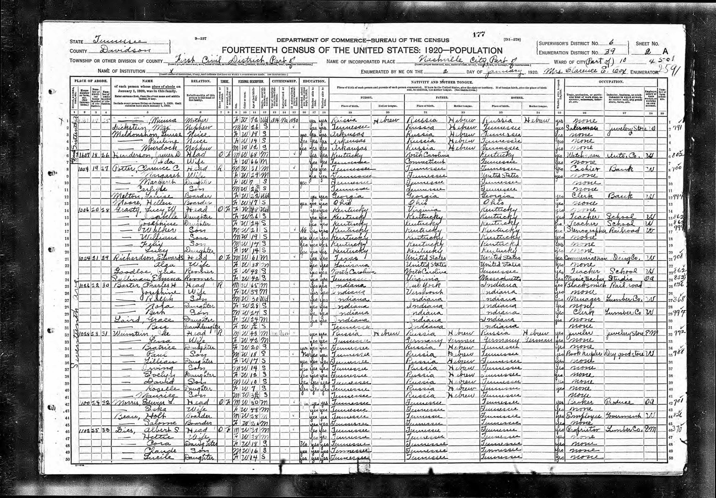
- The chain of title and the federal census. The Davidson County deeds were read from the recorded instruments; the originating 1927 conveyances for the surrounding lots were pulled to establish who held what, and when. The census sheets (1930, 1940, 1950) were read from the National Archives page images to fix the Beans’ household on the ground and to confirm the lot-by-lot walk of the enumerator along the street.
- The commission’s own documentary output — the published Short History and the verbatim transcript of the December 17, 2025 MHZC hearing — read for what the commission conceded against its own conclusion. The Metro Planning Department, which oversees the MHZC, affirms the identification presented here.
Sources
Primary documents — period reporting (public domain; published before 1929)
- The Nashville Tennessean, December 12, 1926, p. 31 — Model Home groundbreaking; architect’s rendering of the “Dream Home”; architects Tisdale, Stone and Pinson; owner John Calhoun.
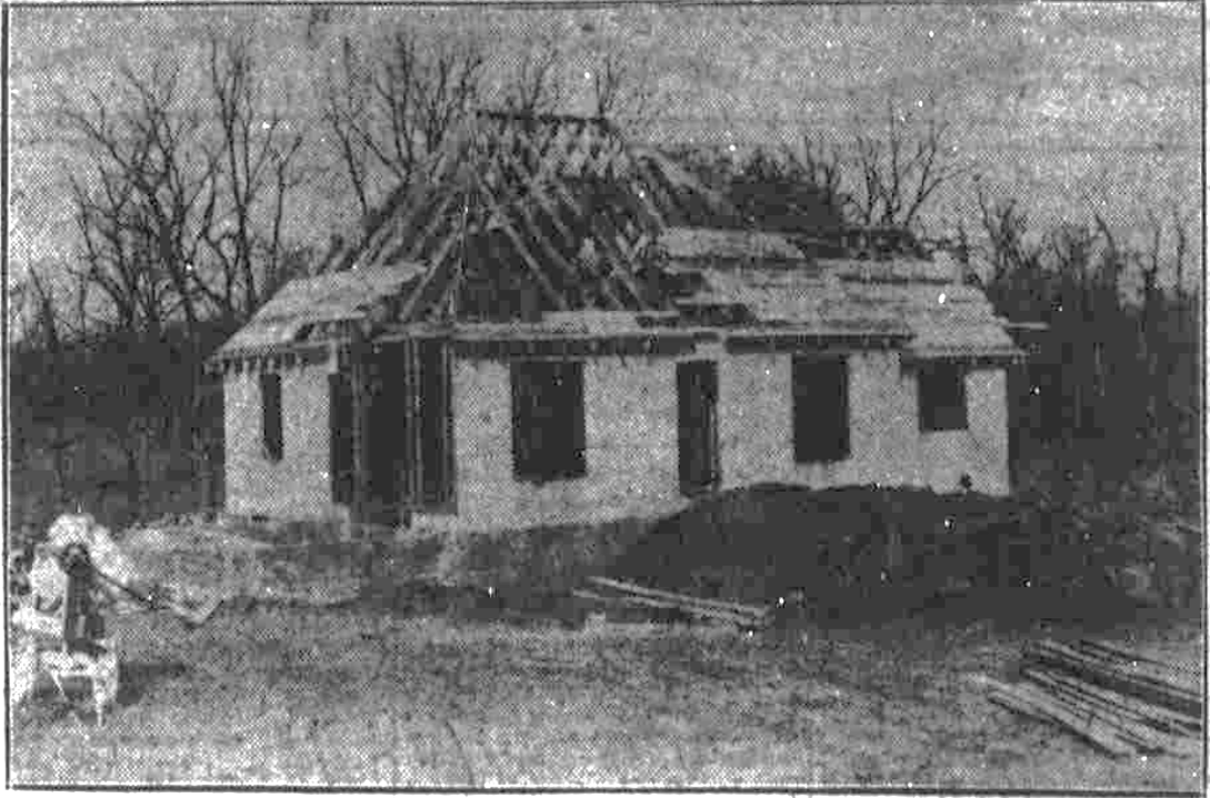
- The Nashville Tennessean, January 30, 1927, p. 34 (subhead: “Contractor T. J. Haile, Jr., Rushing Structure to Open to Public in Late March”) — construction-progress photograph by staff photographer C. J. Burnell, showing wood stud walls.
- The Nashville Tennessean, February 6, 1927, p. 32 — construction-progress photograph by staff photographer C. J. Burnell, showing sheathed walls and erected roof framing, before any masonry.
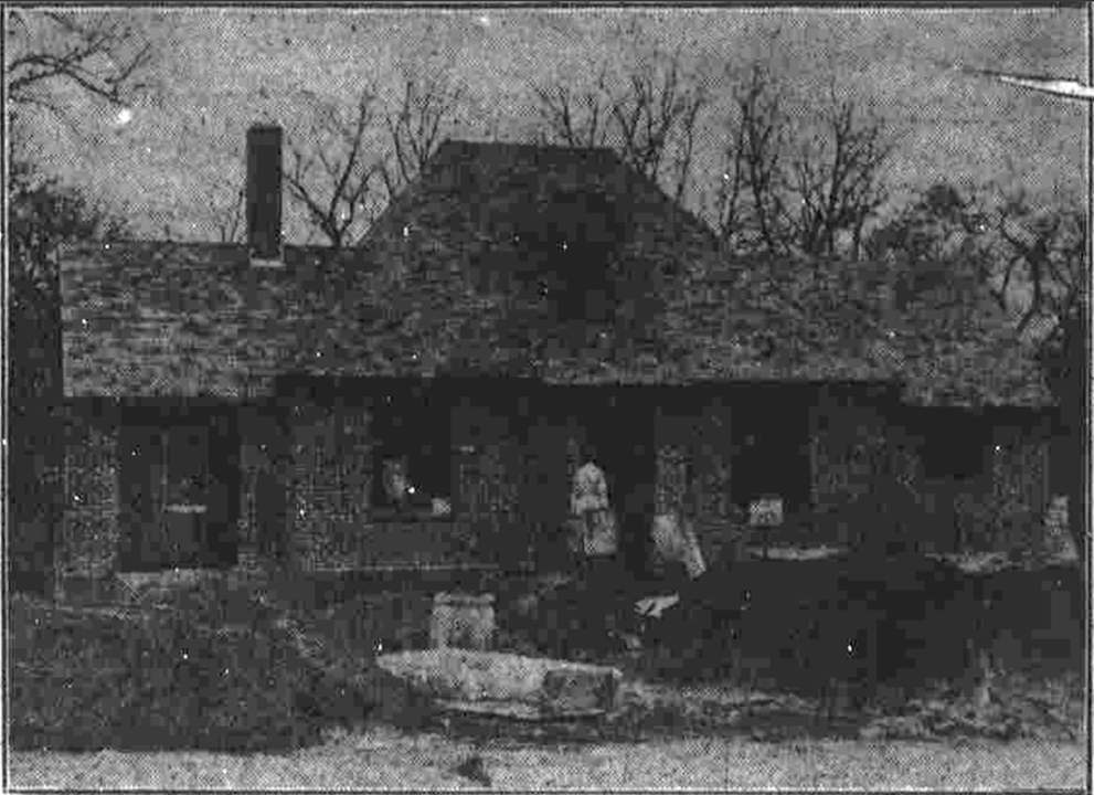
- The Nashville Tennessean, February 27, 1927, p. 24 — “Exterior of Model Home Nearing Completion — Brick Veneer Practically Completed.”
- The Nashville Tennessean, March 20, 1927, p. 20 — “Tennessean Model Home Will Be Completed In Short Time.” The boxed roster “Contractors and Firms Aiding In Tennessean Model Home Work” names the builder, “Thos. J. Haile, Jr.,” with the owner (John C. Calhoun), Nashville Trust Co. (Frank Welsh), and the architects (Tisdale, Stone & Pinson), among the contributing firms’ advertisements on the page.
- The Nashville Tennessean, April 17, 1927 — the basement detail: “[r]oom for [four] automobiles is left in the basement,” reached by “[t]he concrete drive, leading from Observatory drive into the basement.”
- The Nashville Tennessean, May 1, 1927, p. 20, and May 2, 1927, p. 1 — opening-day coverage; interior description including “beamed ceilings”; the brick “painted to give it an antique” finish; basement garage, servants’ quarters, and laundry.
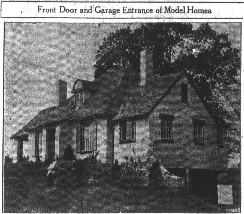
- The Nashville Tennessean, May 6, 1927, p. 20 — paired photograph of the front door and the basement-level garage entrance (“As attractive from one angle as the other”).
- The Nashville Tennessean, May 16, 1927, p. 1 — “Home Purchased; Many Visit House,” reporting Holt Bean’s purchase, the “8-room cream-painted brick structure with servants quarter and two inbuilt garages in the basement,” and the “sits, regally, yet snugly, on its picturesque setting” line.
Primary documents — maps and property records (Davidson County Register of Deeds; Library of Congress)
- Sanborn Fire Insurance Map from Nashville, Davidson County, Tennessee, Aug. 1929–Apr. 1938, Geography and Map Division, Library of Congress — sheet covering 1612 North Observatory Drive.
- Davidson County Plat Book 547, p. 128 — “Plat of Section 1, Green Hills Subdivision,” W. B. Southgate, surveyor, “As Subdivided for John Calhoun.” Davidson County Register of Deeds, Plat Book 547, p. 128
- Davidson County Deed Book 919, p. 110 — T. J. Haile Jr. and wife to Holt and Salome Bean, deed dated May 23, 1927, recorded November 13, 1933 (Lot 6). Davidson County Register of Deeds, Deed Book 919, p. 110
- Davidson County Deed Book 1427, p. 275 — Noel-estate trustees to Holt and Salome Bean, 1946, naming “Lot No. 6 … owned by Holt Bean.” Davidson County Register of Deeds, Deed Book 1427, p. 275
- Davidson County Deed Book 716, p. 312 — American Trust Company, Trustee, to Mizella Burton Grant, deed dated December 15, 1926, recorded January 12, 1927 (Lots 12 and 13). Davidson County Register of Deeds, Deed Book 716, p. 312
- Davidson County Deed Book 700, p. 500 — American Trust Company, Trustee, to John S. and Mildred Moore Milam, recorded January 18, 1927 (Lot 4). Davidson County Register of Deeds, Deed Book 700, p. 500
Primary documents — census
- 1930 U.S. Census, Davidson County, ED 19-220, Sheet 7A (enumerated April 7, 1930) — Bean household, dwelling 129, on Observatory Drive.
- 1940 U.S. Census, Davidson County, ED 19-264, Sheets 3A–3B — Milam (Lot 4), Bean (Lot 6), Gore (Lot 7), Hunt (Lots 12–13), Creighton (Lot 14) in lot sequence.
- 1950 U.S. Census, Davidson County, ED 19-72 — Bean at “1612 N Obser[v]atory Drive”; Milam at 1608; Hunt at 1637.
Primary documents — the commission’s own
- A Short History of Historic Green Hills East, Metropolitan Historic Zoning Commission, posted to nashville.gov, January 10, 2025.
- MHZC public hearing, December 17, 2025, verbatim transcript (Green Hills East section).
Findings
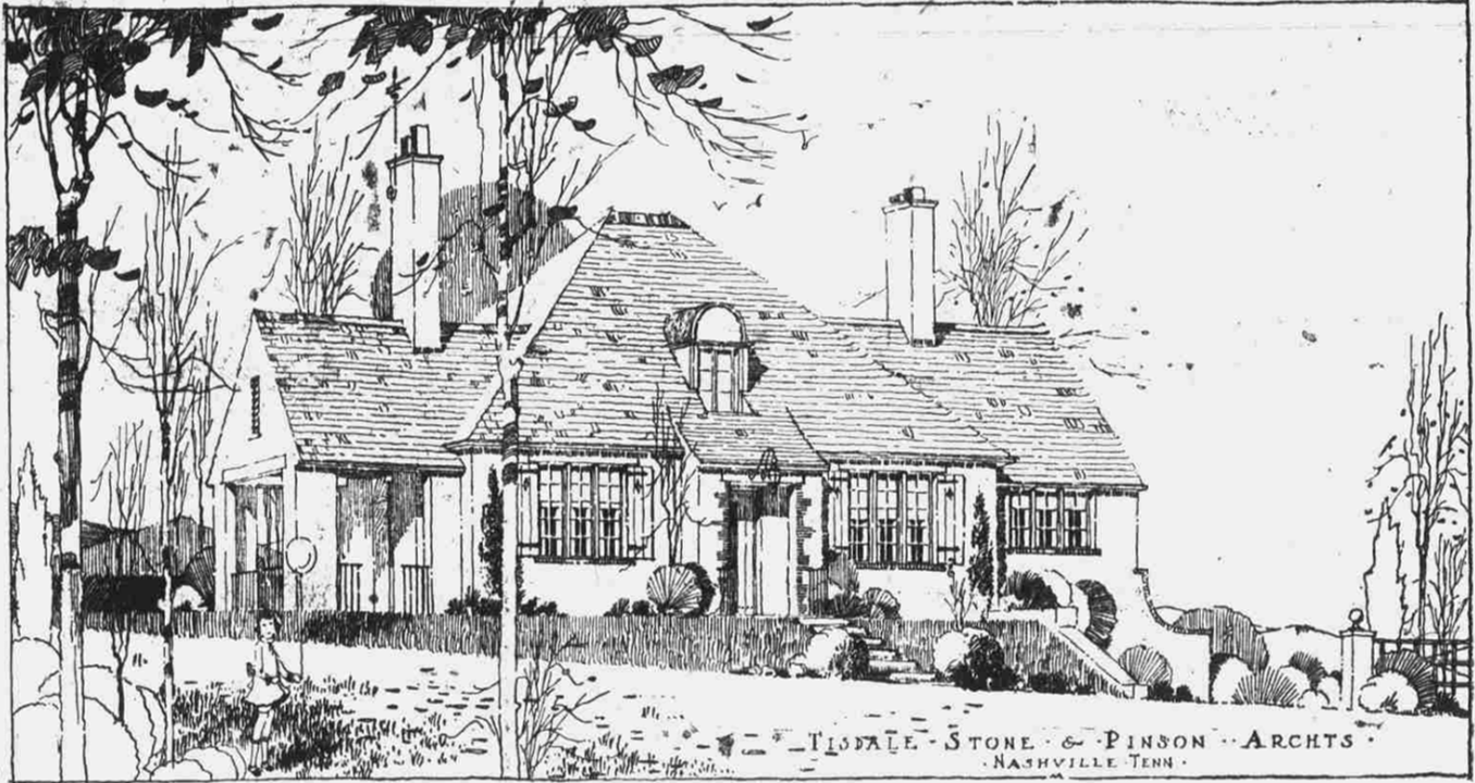 “Architect’s drawing of the ‘Dream Home,’” The Nashville Tennessean, December 12, 1926, p. 31 — the published rendering of the Tennessean Model Home. (Public domain.)
The architecture: 1612 N Observatory is the house the Tennessean drew and photographed
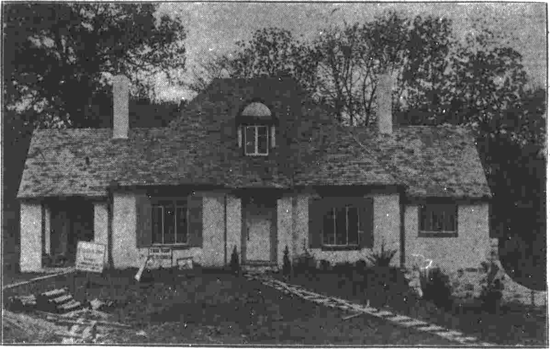
The Tennessean Model Home the newspaper rendered on December 12, 1926 and documented through its May 1, 1927 opening day is a compact, picturesque English Cottage-style house with a steep hipped roof broken by a half-round dormer, two gabled wings carrying ridge chimneys, and a curved wing wall, set on a lot that falls away to the side so the basement opens at grade. Burnell’s construction photographs of January 30 and February 6, 1927 show the structure going up as wood stud walls and wood roof framing, with no masonry; on February 27 the paper reported the “Brick Veneer Practically Completed.” The brick was then painted, in the period phrasing, to give the house an “antique atmosphere” — the May 16, 1927 sale article calls it an “8-room cream-painted brick structure.” These features are present at 1612 N Observatory and absent at 1637 S Observatory, the structure Commissioner Smith described from the dais as “a huge home that’s over two lots with a swimming pool with white painted brick.”
 The Model Home going up in wood frame, before any masonry, The Nashville Tennessean, early 1927 (photographs by C. J. Burnell, January 30 and February 6, 1927). (Public domain.)
 The same house with its brick veneer in place but not yet painted — the paper reported the “Brick Veneer Practically Completed,” The Nashville Tennessean, February 27, 1927. (Public domain.)
 The finished house — the “8-room cream-painted brick structure,” its veneer painted to an “antique” finish, The Nashville Tennessean, May 1927. (Public domain.)
 An oblique view of the completed Model Home on its side-sloping lot, the basement garage opening at grade, The Nashville Tennessean, 1927. (Public domain.)
The basement is the most physically distinctive of the diagnostic features, and the Tennessean described it in detail. On April 17, 1927 the paper reported that “[r]oom for [four] automobiles is left in the basement, although actual provision has been made for only two,” reached by “[t]he concrete drive, leading from Observatory drive into the basement” — a drive-in garage cut into the slope, visible from the street and photographed by Burnell on May 6, 1927 as the “Garage Entrance of Model Home.” The same below-grade level held the laundry, the furnace, and a servant’s room with its own shower, furnished for the opening by Sterchi Bros. That service level is the built form of Plat 1’s fourth covenant, which barred occupancy by any “person of African blood or descent … except in the capacity of servants.” The 1930 census records the Beans’ maid, Sally Carpenter, twenty-eight, living in the house in the one capacity the deed permitted. The basement room materialized the household arrangement the covenant clause codified.
An oblique view of the completed Model Home on its side-sloping lot, the basement garage opening at grade, The Nashville Tennessean, 1927. (Public domain.)
The basement is the most physically distinctive of the diagnostic features, and the Tennessean described it in detail. On April 17, 1927 the paper reported that “[r]oom for [four] automobiles is left in the basement, although actual provision has been made for only two,” reached by “[t]he concrete drive, leading from Observatory drive into the basement” — a drive-in garage cut into the slope, visible from the street and photographed by Burnell on May 6, 1927 as the “Garage Entrance of Model Home.” The same below-grade level held the laundry, the furnace, and a servant’s room with its own shower, furnished for the opening by Sterchi Bros. That service level is the built form of Plat 1’s fourth covenant, which barred occupancy by any “person of African blood or descent … except in the capacity of servants.” The 1930 census records the Beans’ maid, Sally Carpenter, twenty-eight, living in the house in the one capacity the deed permitted. The basement room materialized the household arrangement the covenant clause codified.
The match runs deeper than the exterior. The May 1927 photographs show a beamed ceiling and an inset shelving niche, both still visible in the 2014 listing video of 1612 (Pilkerton Realtors; Showcase Photographers). The house retains the customizations of its 1927 interior, documented photograph by photograph in The Model Home’s Interior: A Century of Photographic Evidence.
The 1938 Sanborn map records 1612 N Observatory as frame with brick veneer over a basement garage
Sanborn fire-insurance maps were drawn for underwriters, who priced risk on the facts in dispute here: whether a wall was masonry or frame, whether a garage was attached and below grade, the footprint of the dwelling, and its position on the lot. The 1938 Nashville sheet for 1612 N Observatory marks the dwelling — with yellow fill and a pink border, the standard Sanborn notation for a wood-framed house with a masonry skin — over a basement garage, on a footprint similar to the floor plan printed in The Nashville Tennessean. That is the construction sequence Burnell photographed in 1927 (frame, then veneer) and the basement-garage-on-a-slope the paper photographed on May 6, 1927. The 1938 sheet confirms it independently: the standing house at 1612 is wood-frame, brick-veneered, with a drive-in basement garage, exactly as the Tennessean Model Home was built.
Deeds and census records fix Holt Bean to 1612 N Observatory Drive
Deed Book 919, page 110 records the conveyance of Lot 6 from T. J. Haile Jr. and his wife to Holt and Salome Bean, the deed dated May 23, 1927 — one week after the paper reported the sale to Bean. Haile was the Model Home’s own builder, and the Tennessean documented it from the December 1926 groundbreaking through opening day: the January 30, 1927 construction report ran under the subhead “Contractor T. J. Haile, Jr., Rushing Structure to Open to Public in Late March,” and the March 20, 1927 feature carried a boxed roster, “Contractors and Firms Aiding In Tennessean Model Home Work,” that named “Thos. J. Haile, Jr.” as the builder among the firms furnishing the house, set on the page among those firms’ own advertisements. The builder the newspaper named is the grantor who, weeks after the house opened for public viewing, deeded Lot 6 to the Beans. The chain runs from the David Lipscomb College trust through American Trust Company to Haile, who held the lot through construction and then conveyed it to the Beans, and onward through Salome Bean’s 1962 sale to Edith Lynch, the Lynches, and the Chapmans to the present owners. A later instrument affirms ownership: in 1946 the Noel-estate trustees, conveying adjoining Glen-Echo land to the Beans, described their starting point as “the southwest corner of Lot No. 6 … and being the [land] owned by Holt Bean” (Book 1427, p. 275).
The census corroborates. In 1930 the enumerator — Leo L. Boles, a Lipscomb College science professor and son of the college’s then-president — recorded the Bean household at dwelling 129 on Observatory Drive, between the Milams at 128 and the Suttons at 130, the house owned and valued at $16,000. By 1950 the address is written out as “1612 N Obser[v]atory Drive,” with the same Milam family next door at 1608 — the lot sequence the 1940 enumerator walked as Milam (Lot 4), Bean (Lot 6), Gore (Lot 7). The plat fixes Lot 6 at the bend of the horseshoe, which is precisely where the Short History itself says the Model Home stood: “the center plot or ‘bend in the largest horseshoe.’” Lots 12 and 13 sit on the far toe of the horseshoe, not at the bend.
The deeds also rule out 1637 S Observatory. Lots 12 and 13 were conveyed to Mizella Burton Grant by a deed dated December 15, 1926 and recorded January 12, 1927 (Book 716, p. 312) — four months before Bean’s purchase, and before the Tennessean Model Home was even finished. From Grant the title runs to the Hunts, the Schwartzes, the Hamiltons, and the Beverstein trust, the current owner. Holt Bean appears nowhere in it. The 1940 census marks the separation: the enumerator walked the Bean household at Lot 6 and the Hunt household at Lots 12–13 on the same route the same day, two distinct families on two distinct lots at distinct points along the street. (Grant’s own story — a daughter of Life and Casualty Insurance founder A. M. Burton — is told in The Misidentified Lot: 1637 South Observatory and the Burton Cluster.)
The MHZC saw the model home plan at 1612 N Observatory, saw a different house at 1637 S Observatory, and never reconciled the two
The strongest witness against the commission’s address is the commission. Its Short History states that “[s]ignificant additions [to 1637 S Observatory] have been constructed over the years but the house plan is also evident in the house constructed at 1612 N Observatory.” MHZC staff offered no evidence or confirmation that the house at 1637 S Observatory had been expanded, while conceding that the original Model Home plan is legible at 1612 N Observatory. At the December 17, 2025 hearing the contradiction surfaced in real time. Commissioner Matthew Smith opened deliberation by asking the staff:
“What’s the status of 1637 South Observatory? Is it contributing still?”
The staff lead, Robin Zeigler, would not answer:
“I don’t have the list with me right now, so I can’t answer specific questions like that.”
Smith pressed, then voiced the doubt directly:
“Okay. Um, interesting. … I don’t see how one model home that does not appear to be contributing today… It looks like a huge home that’s over two lots with a swimming pool with white painted brick. Maybe I’ve got the addresses wrong.”
He had not. Smith cast the lone dissenting vote, and the rest of the commission voted to recommend the overlay over his objection without resolving the issue he had raised. The likely mechanism of the misidentification is the paper’s own promotional sketch map: an April 1927 Tennessean drawing with stylized streets and no lot numbers, read onto the wrong arm of the horseshoe, with no confirmation from the recorded plat and deeds. The two households now at the toe of the horseshoe — the Beverstein trust at 1637 (Lots 12–13) and Dylan Reeves at 1635 (Lot 14) — both opposed the overlay, and both own lots whose chains of title, running back to Mizella Burton Grant in 1927 and the Creighton family in 1935, touch no Bean conveyance and no model home transaction. The architecture, the Sanborn map, the deeds, and the census all point to Lot 6, to 1612 N Observatory.
Presented with this evidence, and after reviewing the staff research behind the Short History, Planning Department chief of staff Richel Albright — with approval from Executive Director Lucy Kempf — affirmed by email on June 3, 2026 that 1612 N Observatory is the Tennessean Model Home.
Bibliography
Metropolitan Historic Zoning Commission. A Short History of Historic Green Hills East. Nashville: Metropolitan Government of Nashville and Davidson County, January 10, 2025.
Metropolitan Historic Zoning Commission. Public hearing transcript, Green Hills East historic overlay, December 17, 2025.
The Nashville Tennessean. “Architect’s Drawing of the ‘Dream Home.’” December 12, 1926.
The Nashville Tennessean. “Frame Work of Model Home in New Green Hills Subdivision Completed.” January 30, 1927.
The Nashville Tennessean. “Tennessean Model Home Is Taking Shape.” February 6, 1927.
The Nashville Tennessean. “Exterior of Model Home Nearing Completion — Brick Veneer Practically Completed.” February 27, 1927.
The Nashville Tennessean. “Tennessean Model Home Will Be Completed In Short Time.” March 20, 1927.
The Nashville Tennessean. “Model Home Will Open Today.” May 1, 1927.
The Nashville Tennessean. “Tennessean’s Model Home Thrown Open To Throng of 15,000.” May 2, 1927.
The Nashville Tennessean. “Front Door and Garage Entrance of Model Home.” May 6, 1927.
The Nashville Tennessean. “Tennessean Model Home Purchased; Many Visit House.” May 16, 1927.
Sanborn Map Company. Insurance Maps of Nashville, Tennessee. New York: Sanborn Map Company, Aug. 1929–Apr. 1938. Geography and Map Division, Library of Congress.
U.S. Census Bureau. Fifteenth Census of the United States, 1930. Davidson County, Tennessee, Enumeration District 19-220.
U.S. Census Bureau. Sixteenth Census of the United States, 1940. Davidson County, Tennessee, Enumeration District 19-264.
U.S. Census Bureau. Seventeenth Census of the United States, 1950. Davidson County, Tennessee, Enumeration District 19-72.
Davidson County Register of Deeds. Plat Book 547, p. 128; Deed Book 700, p. 500; Deed Book 716, p. 312; Deed Book 919, p. 110; Deed Book 1427, p. 275. Nashville, Tennessee.
Suggested Citation
Pemberton, Alex. “Identifying the Model Home: 1612 North Observatory.” Research Brief E1, Veneers of History in Green Hills East. alexaustinpemberton.com/journalism/veneers-of-history/#model-home-identification. Accessed [date].
Plat 1, Covenant 4: The Racial Covenant in the Green Hills Deeds
Abstract
The MHZC’s “Short History of Historic Green Hills,” produced to support the proposed conservation overlay, cites the minimum construction cost covenant in the Plan of Green Hills originating deeds and omits the racial covenant on the same page. The two restrictions are consecutive in one instrument. The racial covenant barred ownership or occupancy by persons of African blood or descent until 1960, with one exception: such persons could be present in the capacity of servants. That exception — the only form of Black presence the deed admitted — defines the social order the instrument assumed, separating who may own the subdivision from who may work in it. A Nashville college, conveying its land through a trustee, wrote the covenant into the title chain, where it ran with every Plat 1 lot for thirty-three years. For the legal history and the cases that ended enforcement, see Racial Covenants and Shelley v. Kraemer.
Methodology
The covenant text is read from the deed, not from a database. The clause was confirmed by direct image inspection of the recorded page at Book 770, pages 41–42 (Plat 1) and page 568 (Plat 2), Davidson County Register of Deeds. The deed images were enlarged at 400 and 600 dpi for legibility at the line, and every quoted word was matched against those enlargements of the recorded page.
The Holt Bean deed (Book 919, p. 110), which carries the Plat 1 covenants by reference, was pulled from the Davidson County Register of Deeds portal; the instrument is dated May 23, 1927. The MHZC’s handling of the deed restrictions — the minimum-cost clause cited, the racial clause on the same page not — is documented through the “Short History of Historic Green Hills” as presented at the Dec. 17, 2025 MHZC public hearing (agenda item 13, PermitID 20250100809).
Sources
Primary documents
- Davidson County Register of Deeds, Book 770, pp. 41–42. Plat 1 covenants, Plan of Green Hills. Grantor: American Trust Company, Trustee under power from David Lipscomb College. Executed 1927. Contains the racial covenant (Covenant 4) verbatim.
- Davidson County Register of Deeds, Book 770, p. 568. Plat 2 covenants, Plan of Green Hills. Identical racial covenant clause.
- Davidson County Register of Deeds, Book 919, p. 110. Deed from T. J. Haile Jr. and wife to Holt and Salome Bean. Executed May 23, 1927; recorded November 13, 1933. Covenants incorporated by reference from Plat 1. Portal: Davidson County Register of Deeds, Deed Book 919, p. 110
- A Short History of Historic Green Hills East, MHZC. Submitted in support of proposed Green Hills East Neighborhood Conservation Zoning Overlay, BL2025-1175 and BL2025-1176. Presented Dec. 17, 2025 MHZC public hearing.
- MHZC Dec. 17, 2025 Final Agenda, Item 13 (PermitID 20250100809)

Findings
The covenant is at Book 770, pages 41–42
Covenant 4 of the Plat 1 restrictions reads: “Neither said property nor any part thereof shall be aliened or conveyed to persons of African blood or descent and no person of African blood or descent shall be permitted to own or occupy the premises except in the capacity of servants.” Those are the words on the recorded page.
The same clause runs at Book 770, page 568, for Plat 2
The restriction governed both recorded plats of the Plan of Green Hills as the subdivision was laid out in 1927, reaching the full lot count across the subdivision.
The grantor was a college
David Lipscomb College held the land and disposed of it through American Trust Company as Trustee, the trust’s authority established by the underlying deed of trust at Book 700, page 428; American Trust executed the individual lot deeds. The institution that wrote the racial restriction into the title chain was a Nashville school.
The covenant ran with the land until January 1, 1960
The termination date is stated in the deed itself. For thirty-three years it passed with every conveyance and bound each successive owner; it did not lapse with the original parties. A buyer in 1955 took the lot subject to it as surely as a buyer in 1927.
The minimum-cost clause and the racial clause sit on the same page
The MHZC’s Short History reports the first and passes over the second. The two are consecutive restrictions in one instrument, governing one tract under one deed — and the history sourced its cost figure to the Tennessean, never citing the deed where the racial clause sits beside it (see The Sources of the Short History). Reading the instrument behind the figure would have put the racial covenant directly in front of the author.
The “servants” exception defines who could be present, and how
The clause permits one form of Black presence, occupancy as a servant, and forbids every other. The deed separates who may own the subdivision from who may work in it, and draws that line deliberately. Black residents were admitted as labor and barred as owners.
The encumbrance reached the ordinary buyer
Holt Bean took his lot on May 23, 1927, weeks after the subdivision’s opening sales campaign, on a deed from the Model Home’s builder (Book 919, p. 110) that pulls in the Plat 1 restrictions by reference. His deed was typical. The author’s chain-of-title dataset for the subdivision, built from the 1927 originating deeds recorded with the Davidson County Register of Deeds, shows the covenant carried inline or by cross-reference across the lots. The restriction was the rule of the place.
Whether anyone tried to enforce Covenant 4 against a named buyer during its 1927–1959 run, and how a Davidson County Chancery court would have ruled after Shelley (1948), is a question of legal history (see Racial Covenants and Shelley v. Kraemer).
Bibliography
Davidson County Register of Deeds. Book 770, pp. 41–42. Plan of Green Hills, Plat 1 Covenants. Davidson County, Tennessee, 1927.
Davidson County Register of Deeds. Book 770, p. 568. Plan of Green Hills, Plat 2 Covenants. Davidson County, Tennessee, 1927.
Davidson County Register of Deeds. Book 919, p. 110. T. J. Haile Jr. and wife to Holt and Salome Bean. Davidson County, Tennessee. Executed May 23, 1927; recorded November 13, 1933.
Metropolitan Historic Zoning Commission. A Short History of Historic Green Hills East. Nashville, TN: Metro Nashville Planning Department, 2025. Submitted in support of BL2025-1175.
Metropolitan Historic Zoning Commission. Final Agenda, December 17, 2025. Nashville, TN: Metro Nashville, 2025.
Suggested Citation
Pemberton, Alex. “Plat 1, Covenant 4: The Racial Covenant in the Green Hills Deeds.” Research Brief E2, Veneers of History in Green Hills East. alexaustinpemberton.com/journalism/veneers-of-history/#plat-1-racial-covenant. Accessed [date].
The Misidentified Lot: 1637 South Observatory and the Burton Cluster
Abstract
The lot the Metropolitan Historic Zoning Commission misidentified as the 1927 Tennessean Model Home was not owned by Holt Bean — it was owned by Mizella Burton Grant. Grant was the daughter of Andrew M. Burton, founder of the insurance company at which Bean rose to executive rank and for which a street in the subdivision is named. Bean never owned the misidentified lot, as Identifying the Model Home: 1612 North Observatory, Not 1637 South shows; what the lot actually is follows from its own deed record. Grant purchased it in January 1927, in the same originating-deed round that placed Bean six lots away, and held it for nine years. The chain of title and census records together confirm that the commission’s wrong house and the right house belong to the same employer-patriarch network. The fuller account of Bean’s career and the Burton connection is in Holt Bean: A Life.
Sources
Primary documents
- American Trust Company, Trustee, to Mizella Burton Grant, Davidson County Deed Book 716, page 312 (dated Dec. 15, 1926; recorded Jan. 12, 1927). Originating deed for Lots 12 and 13; $2,400 cash; inline racial covenant present.
- Mizella Burton Grant and Otis P. Grant to William B. Hunt and Geneva Taylor Hunt, Deed Book 1011, page 296 (dated Aug. 28, 1936; recorded Sept. 5, 1936). $9,500: $3,500 cash plus assumption of a $6,000 Grant mortgage at Book 751, page 692. Derivation back to Book 716, page 312.
- Sixteenth Census of the United States (1940), Tennessee, Davidson County, Civil District No. 7, Enumeration District 19-264, Sheet 3A. Records the Bean household at household 53 (Holt J. Bean, “Investment Manager, Insurance Co”); the same ED records the Andrew M. Burton household on Hillsboro Road, including daughter Mizella Grant (b. 1906) and son-in-law Otis P. Grant (“Personnel Director”).
- Green Hills Subdivision Plat 1, Davidson County Plat Book 547, page 128; master covenant, Book 770.
- Davidson County ParcelViewer record for parcel 186563 (APN 11715008400), “LOT 12&13 GREEN HILLS SUB,” current owner Observatory Dr Revocable Trust.
Findings
The misidentified house is 1637 South Observatory — Lots 12 and 13, not the model home’s Lot 6
The MHZC nomination treats 1637 South Observatory as the site of the 1927 Tennessean Model Home. The model home stood at 1612 North Observatory Drive (Lot 6), on the opposite arm of the Observatory Drive horseshoe; the 1940 enumerator walked past both the Bean home and the Hunt-owned Lots 12 and 13 on the same day, on the same sheet. Two distinct households, two distinct lots, opposite sides of the loop. The proof that 1637 South is not the model home is set out in Identifying the Model Home: 1612 North Observatory, Not 1637 South; the misidentification is taken as given here, and the question is what 1637 actually is.
Lots 12 and 13 were bought in January 1927 by Mizella Burton Grant
The originating deed (Book 716, page 312) conveyed the two lots together from American Trust Company, as trustee, to Grant for $2,400 cash, recorded January 12, 1927 — in sequence with the other early-1927 Green Hills originating deeds, the same round that conveyed Lot 6 to T. J. Haile Jr., the builder from whom Holt Bean would buy the Model Home that May. The all-cash $2,400 was the largest cash figure recorded across the studied lots — a sign of means, not of a mortgage-dependent first home.
Grant held the lots nine years and sold to the Hunts in 1936
On August 28, 1936, Mizella Burton Grant and her husband Otis P. Grant conveyed Lots 12 and 13 to William B. and Geneva Taylor Hunt for $9,500 — $3,500 cash plus assumption of a $6,000 mortgage Grant had taken at Book 751, page 692 (Book 1011, page 296). From the Hunts the title ran to the Schwartzes (1973), the Hamiltons (1978), and finally the Beverstein family’s Observatory Drive Revocable Trust, the present owners who objected on the record to the use of their house as the overlay’s central artifact. Holt Bean appears nowhere in this chain.
Mizella Burton Grant was A. M. Burton’s daughter, and Burton’s company became Holt Bean’s
The 1940 census household on Hillsboro Road records Andrew M. Burton (head, 60), founder of the Life and Casualty Insurance Company, with his daughter Mary J. and a married daughter, Mizella Grant (34, b. 1906), and her husband Otis P. Grant. Life and Casualty is the company Bean joined in 1934 — seven years after both families bought into the subdivision — and where he rose to vice president. Burton’s daughter took title to the lot the commission would, decades later, mistake for Bean’s; Bean made his career at her father’s firm. The census and city-directory record establishes the Life and Casualty link between the two men; the claim sometimes attached to the pair, that Burton personally recruited Bean, rests on no record (see Holt Bean: A Life).
The wrong house and the right house sit in one network
The favored quarter of Green Hills was assembled by a small, interlocking set of insurance executives and their families in a single development season. Grant, Burton’s daughter, on Lots 12 and 13; Bean, Burton’s future vice president, on Lot 6. The wrong house and the right house sit inside one corporate and family network. Whether other January 1927 Green Hills buyers were also Life and Casualty figures, which would widen the cluster from a coincidence into a pattern, is not yet established: a buyer-by-buyer occupational audit of the 1927 cohort is not in the record, though The Better Homes in America Movement frames the marketing apparatus that drew such buyers.
The cluster finding rests on the Burton–Bean shared employer, which the census and directories establish; personal recruitment rests on no record (see Holt Bean: A Life). The lot is recorded as 1637 South Observatory throughout the deed and parcel record, though it has at times been called “North.” The $2,400 all-cash figure is the highest among the lots studied, not a figure for every 1927 Green Hills deed.
Bibliography
American Trust Company, Trustee, to Mizella Burton Grant. Deed Book 716, page 312. Davidson County, Tennessee. Dated December 15, 1926; recorded January 12, 1927.
Grant, Mizella Burton, and Otis P. Grant, to William B. Hunt and Geneva Taylor Hunt. Deed Book 1011, page 296. Davidson County, Tennessee. Dated August 28, 1936; recorded September 5, 1936.
Green Hills Subdivision, Plat 1. Plat Book 547, page 128. Davidson County, Tennessee.
U.S. Bureau of the Census. Sixteenth Census of the United States, 1940. Tennessee, Davidson County, Civil District No. 7, Enumeration District 19-264, Sheet 3A. Washington, DC: National Archives and Records Administration.
Suggested Citation
Pemberton, Alex. “The Misidentified Lot: 1637 South Observatory and the Burton Cluster.” Research Brief E3, Veneers of History in Green Hills East. alexaustinpemberton.com/journalism/veneers-of-history/#misidentified-lot-1637. Accessed [date].
Holt Bean: A Life
Abstract
Four federal censuses and his own 1960 obituary trace Holt Bean from a downtown Nashville boarder with a government job to the owner of the city’s most-publicized new house, then across three decades to a vice presidency at the insurance company whose founder owned land in the suburb around him. The arc — clerk to model-home owner to corporate officer — is the precise trajectory the Better Homes in America movement existed to advertise: professional, suburban, ascending. Bean was real, and he bought the house. The census record also catches what the movement’s advertising omitted. Within three years of purchase, a Black domestic worker named Sally Carpenter was enumerated in his household, and every Plat 1 deed barred occupancy by persons of African blood or descent except in the capacity of servants. Bean spoke at a neighborhood civic league eight days after the Supreme Court agreed to hear the case that would make those covenants unenforceable. He died on April 29, 1960, the year his covenant expired.
Sources
Primary documents
- Fourteenth Census of the United States, 1920 — Population. Tennessee, Davidson County, Nashville City (Part), Ward 10, First Civil District (Part), Enumeration District 39, Sheet 2A (bound volume sheet 177). Enumerated January 2, 1920 by Mrs. Clarence E. Cox. Lines 44–45: Holt and Salome Bean, boarders in the Edwin L. Morris household. NARA, Record Group 29; microfilm publication T625.
- Fifteenth Census of the United States, 1930 — Population. Tennessee, Davidson County, Civil District No. 7 (Part), Enumeration District 19-220, Sheet 7A. Enumerated April 7, 1930 by Leo L. Boles. Lines 15–18, dwelling 129, family 135: the Bean household with servant Sally Carpenter; home value entered as $16,000 owned. NARA, Record Group 29; microfilm publication T626.
- Sixteenth Census of the United States, 1940 — Population. Tennessee, Davidson County, Civil District No. 7, Enumeration District 19-264, Sheet 3A. Enumerated April 22, 1940 by Mrs. Lucile L. Smith. Household 53: “Bean, Holt J.,” head, age 49, “Investment Manager,” “Insurance Co,” wage income $5,000; home value $10,000 owned. NARA, Record Group 29; microfilm publication T627.
- Seventeenth Census of the United States, 1950 — Population and Housing. Tennessee, Davidson County, Civil District No. 7, Enumeration District 19-72, Sheet 4. Sheet begun April 3, 1950; enumerator Mrs. Clara W. Sadler. Household 38, address 1612: “Bean, Holt,” head, age 59, “Investment Decisions,” “Insurance Co.” NARA, Record Group 29; 1950 census population schedules.
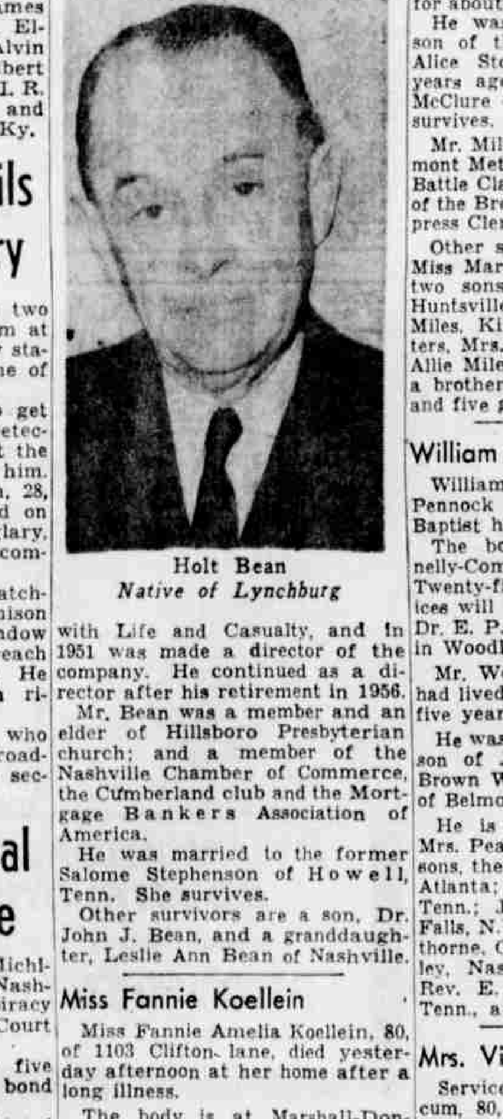
- Nashville Tennessean, April 30, 1960, p. 16: the news obituary “Services Today For Holt Bean” and the photo notice “Holt Bean — Native of Lynchburg.” The firsthand record of the life — birth at Lynchburg, Tennessee, to J. J. and Emma Holt Bean; the Morgan School at Fayetteville; federal government employment from 1913 to 1917, first in Washington and then in Nashville; the mortgage business in Lewisburg and then Nashville with his brother, the late Homer Bean; the move to Life & Casualty in 1934, a directorship in 1951, retirement as a vice president in 1956; membership and an eldership at Hillsboro Presbyterian and a seat in the Mortgage Bankers Association of America; and the death on April 29, 1960. ProQuest Historical Newspapers.
- Nashville Tennessean, April 29, 1960, p. 50, “Holt Bean Dies At Hospital Here.” The day-of-death notice, which records his father, J. J. Bean, as a former state treasurer, and Bean as an elder of Hillsboro Presbyterian. ProQuest Historical Newspapers.
- Nashville Tennessean, May 16, 1927, p. 1, “Tennessean Model Home Purchased; Many Visit House.” Reports that “the Tennessean model home in the Green Hills subdivision has been bought” by “Holt Bean, finance correspondent of the Union Central Life Insurance company,” for $12,000, the deal closed with R. E. Haynes of the Nashville Trust company. ProQuest Historical Newspapers.
- Nashville Tennessean, February 8, 1940, p. 3. Reports Bean’s appointment as manager of Life and Casualty’s residential loan department and fixes the chronology the census abbreviates: associated with the loan investment department from 1934, assistant manager of the investment department from 1937, and, before Life and Casualty, a financial correspondent. ProQuest Historical Newspapers.
- Nashville Tennessean, April 2, 1935, p. 14, substitute-trustee sale notice. The Life and Casualty Insurance Company of Tennessee, holder of a note secured by a November 29, 1930 deed of trust from Luke Lea, names Holt Bean “Successor Trustee” to A. M. Burton — “unable to act, and/or refusing to act as such Trustee” — to sell the pledged Belle Meade lot at the courthouse door on April 17, 1935. ProQuest Historical Newspapers.
- Nashville Tennessean, February 19, 1958, p. 12. Life and Casualty’s published board of directors lists “Holt Bean, Vice President (Retired)” beside Paul Mountcastle (chairman of the board), Guilford Dudley, Jr. (president), A. M. Burton (president emeritus), and Clark H. Hutton. ProQuest Historical Newspapers.
- Nashville Tennessean, March 6, 1975, p. 78, “Mrs. Holt Bean.” The graveside notice for Salome Stephenson Bean, 83, of 1602 Observatory Court — daughter of John Crawford and Amanda Sawyers Stephenson, educated at Fayetteville, married to Holt Bean — naming her surviving granddaughter, Mrs. Leslie Bean Weed. ProQuest Historical Newspapers.
- Tennessee Department of Public Health, certificate of death no. 60-09674 (Holt Bean). Fixes the death on April 29, 1960 at Baptist Hospital, the birth on February 25, 1891, the Observatory Drive residence, and the occupation “retired vice president, Life & Casualty Insurance Co.”
- Nashville city directories (R. L. Polk & Co.), 1913–1960. The annual record of Bean’s residence and occupation.
- Metropolitan Historic Zoning Commission. A Short History of Green Hills East NCZO (Part II) (working draft, 2025), pp. 5–6 — the document under examination, not a source relied on here. Where its career sketch diverges from the obituary, the deed, and the census, those records govern. The recorded purchase price ($12,250) is the deed’s (Davidson County Register of Deeds, Book 919, p. 110); the Short History repeated the Tennessean’s rounded $12,000.
- Nashville Banner, July 2, 1947, p. 6, “Property Owners Form League To ‘Protect’ Area.” Newspapers.com image 603047929. Names Bean among five speakers at the founding of the Granny White–Belmont–Green Hills property-owners’ league. Transcribed in The 1947 Property Owners’ Protective League.
In January 1920 the Beans owned nothing and boarded downtown
The 1920 census places Holt (28) and Salome (26) Bean as boarders, lines 44 and 45, in the Ward 10 household of Edwin L. Morris, a married produce broker of fifty, and his wife Eska. Holt’s occupation reads “Employee,” his industry “Government”; Salome’s columns are blank. There are no children on the line and no servant in the household. The ages fix Holt’s birth at about 1891–92 and Salome’s at about 1893–94, consistent with every later enumeration. This is the floor of the arc: a young married federal clerk, Tennessee-born, with no home and no heirs yet. Whether Morris was a relation or a stranger landlord is not established; the household was downtown, urban, and rented.
The career was federal before it was financial
Bean’s own obituary fixes the chronology the 1920 census corroborates at its hinge. He was born in Lynchburg, Tennessee, to J. J. Bean, a former state treasurer, and Emma Holt Bean, and educated at the Morgan School in Fayetteville. From 1913 to 1917 he was a federal government employee, first in Washington and then in Nashville — the “Employee / Government” the 1920 census still records. Out of the government he went into the mortgage business, in Lewisburg and afterward in Nashville, with his brother Homer Bean.
In the mortgage business, and a life-insurance correspondent by 1927
Bean’s business was the placement of insurance-company capital into real property — farm loans, then mortgage correspondence — the same lending that was, in those years, building the restricted suburb. By 1927 he had moved to the lending arm of a life insurer: announcing the model home’s sale, the Tennessean of May 16, 1927 called the buyer “Holt Bean, finance correspondent of the Union Central Life Insurance company.” The broker of the suburb’s mortgages bought one of its houses.
In May 1927 the Beans bought the Tennessean Model Home for $12,250
Nashville’s demonstration house, at 1612 North Observatory Drive, designed by Tisdale, Stone and Pinson and completed in April 1927, drew fifteen thousand visitors on its May 1 opening day. “The Tennessean model home in the Green Hills subdivision has been bought,” the paper announced on May 16; the buyer was Bean, the price reported at a rounded $12,000. The recorded deed (Davidson County Register of Deeds, Book 919, p. 110) recites a consideration of $12,250; the Tennessean’s rounded figure is the one the Short History then repeated. Seven years separated “Boarder / Employee / Government” from ownership of a publicly toured demonstration house in a highly restricted subdivision. The 1930 census separately enters the home’s value as $16,000 — the enumerator’s value estimate, not a recorded sale price. The companion brief Identifying the Model Home: 1612 North Observatory, Not 1637 South establishes that the model home stands at 1612, the Beans’ lot, and that the commission’s draft history misplaced it six lots away at 1637 South Observatory; the censuses from 1930 forward place the household at 1612.
In 1930 the household included a Black domestic worker under the covenant’s servant exception
The 1930 census records the Beans on Observatory Drive: Holt (39), “Agent,” “Insurance”; Salome (39); their son Jack (7), born about 1923; and, on line 18, “Carpenter, Sally,” relation “Servant,” race “Negro,” sex “F,” age 28, single, Tennessee-born, occupation “Maid,” industry “Private Home.” The home value is entered as $16,000 owned. The Tennessean’s 1927 architectural specifications had described a basement “servant’s room and shower”; by April 1930 the room, or the arrangement it was built for, was occupied. Plat 1’s fourth covenant permitted persons “of African blood or descent” in Green Hills only “in the capacity of servants.” Carpenter’s presence in the household is that clause in practice; her story is told in Sally Carpenter’s Documentary Trail. The household that embodied the movement’s promise of white ascent ran, from the start, on the labor the deed admitted by exception and barred from ownership.
By 1940 the federal clerk of 1920 was an insurance executive
The 1940 census lists “Bean, Holt J.” — the middle initial appears here and only here among the four sheets — head of household 53, age 49, occupation “Investment Manager,” industry “Insurance Co,” with a reported wage income of $5,000 against fifty-hour weeks. Salome (48) keeps house; Jack (17) is at home; no servant is enumerated. The home’s value is entered as $10,000, below the 1930 figure, consistent with Depression-era reassessment. Five weeks before that enumeration, the Tennessean of February 8, 1940 had reported Bean “named manager of the residential loan department” at Life and Casualty, with the rungs beneath it: associated with the loan investment department from 1934, assistant manager of the investment department from 1937. “Investment Manager, Insurance Co” is the census shorthand for that post.
The company was A. M. Burton’s, and Bean stood inside its lending machinery
Life & Casualty Insurance Company was founded by Andrew Mizell Burton (1879–1966), for whom Burton Avenue in the subdivision is named and whom the Short History identifies as an owner of property in Green Hills and a benefactor of Lipscomb. The same 1940 enumeration district contains Burton’s own household on Hillsboro Road; Burton’s daughter, Mizella Burton Grant, had taken title to Lots 12 and 13 of the Green Hills plan in January 1927 (the parcel the MHZC’s draft history misidentified as the model home — see The Misidentified Lot: 1637 South Observatory and the Burton Cluster). The record sets Bean inside Burton’s lending operation by the mid-1930s. When Burton, the named trustee on a 1930 deed of trust the publisher Luke Lea had given to secure a note Life and Casualty held, became “unable to act, and/or refusing to act” as that trustee, the company named Holt Bean his successor; on April 17, 1935, Bean sold the pledged Belle Meade lot at the courthouse door to the highest bidder for cash. Twenty-three years later the insurer’s published board still seated the two men together — A. M. Burton, president emeritus, and Holt Bean, vice president, retired. That Burton personally recruited Bean, as distinct from the trusteeship, the 1951 directorship, and the vice presidency the record fixes, rests on no source.
In 1950 he was still on Observatory Drive, still in insurance, still climbing
The 1950 census records “Bean, Holt,” household 38 at address 1612, head, age 59, occupation “Investment Decisions,” industry “Insurance Co,” with Salome (58) keeping house and Jack — twenty-seven and presumably gone — no longer on the line. The household next door at 1608 is the widowed Mildred Milam and her sons, the consecutive house numbers confirming the Beans’ place on the north frontage at the bend of the horseshoe. Thirty years after boarding in the Morris house, Bean owned his home outright and made investment decisions for an insurance company.
He spoke for the neighborhood’s white property owners in 1947
On July 1, 1947, four hundred residents of the Granny White, Belmont, and Green Hills sections met in the auditorium of David Lipscomb College to form a civic league “for the purpose of ‘protecting interests of property owners in the area,’” and named a standing committee “to keep abreast with zoning regulations.” The Nashville Banner listed Bean among the five speakers. The meeting fell eight days after the Supreme Court agreed to hear Shelley v. Kraemer, ten months before the decision made the covenant on his own deed unenforceable, while that covenant still had twelve years to run; the venue was the college that had held the Plat 1 trust in 1927; the company Bean worked for was Burton’s. Bean was on the program at the founding of the instrument meant to outlast the covenant (see The 1947 Property Owners’ Protective League).
He died in 1960, the year the covenant expired
Holt Bean died on April 29, 1960, at Baptist Hospital, after a two-month illness — a retired vice president of Life & Casualty, made a director of the company in 1951 and retired from its management in 1956 while keeping his seat on the board. He was an elder of Hillsboro Presbyterian and a member of the Nashville Chamber of Commerce, the Cumberland Club, and the Mortgage Bankers Association of America; the burial was at Woodlawn. The Plat 1 racial covenant ran until January 1, 1960. The two endings sit in the same year. Salome outlived him, joining the 1962 replat of Observatory Court with their son, Dr. John J. (Jack) Bean, and moving to 1602-A Observatory Court before her own death on March 5, 1975, survived by a granddaughter, Leslie Ann Bean — Mrs. Leslie Bean Weed. The family’s hold on Observatory Court, begun at the 1927 model home, ran on through a third generation. The covenant Bean lived his entire Green Hills tenure under lapsed by its own terms in the year he died; the family kept platting and building the ground around it for two more years. The instrument that had reserved the street racially expired quietly, on schedule, never once tested in court by the family it protected.
The purchase price — $12,250 — is the consideration recited in the recorded deed (Davidson County Register of Deeds, Book 919, p. 110); the Tennessean’s rounded $12,000, repeated by the MHZC Short History, is the imprecise period-press figure. The 1930 census’s $16,000 and the 1940 census’s $10,000 are enumerators’ home-value estimates, not sale prices. That A. M. Burton personally recruited Bean into Life & Casualty, as opposed to Bean’s documented trusteeship, employment, and 1951 directorship there, rests on no record. The name settles as “Holt Bean” across the 1927 Tennessean, the obituary, and the death certificate, the middle initial surfacing once, as “Holt J. Bean,” in the 1940 census; his father was J. J. Bean, the former state treasurer. The arc the account follows is established firsthand, by the census, the obituary, and the death certificate.
Bibliography
Fourteenth Census of the United States, 1920 — Population. Tennessee, Davidson County, Nashville City (Part), Ward 10, Enumeration District 39, Sheet 2A. National Archives and Records Administration, Record Group 29.
Fifteenth Census of the United States, 1930 — Population. Tennessee, Davidson County, Civil District No. 7, Enumeration District 19-220, Sheet 7A. National Archives and Records Administration, Record Group 29.
Sixteenth Census of the United States, 1940 — Population. Tennessee, Davidson County, Civil District No. 7, Enumeration District 19-264, Sheet 3A. National Archives and Records Administration, Record Group 29.
Seventeenth Census of the United States, 1950 — Population and Housing. Tennessee, Davidson County, Civil District No. 7, Enumeration District 19-72, Sheet 4. National Archives and Records Administration, Record Group 29.
Metropolitan Historic Zoning Commission. A Short History of Green Hills East NCZO, Part II. Nashville: MHZC, 2025. Working draft.
Nashville Banner. “Property Owners Form League To ‘Protect’ Area.” July 2, 1947, p. 6. Newspapers.com image 603047929.
Nashville City Directory. Nashville: R. L. Polk & Co. Consulted years 1913–1960.
The Nashville Tennessean. “Tennessean Model Home Purchased; Many Visit House.” May 16, 1927, p. 1. ProQuest Historical Newspapers.
The Nashville Tennessean. [Life and Casualty residential loan department appointment.] February 8, 1940, p. 3. ProQuest Historical Newspapers.
The Nashville Tennessean. [Substitute-trustee sale notice, Life and Casualty Insurance Company.] April 2, 1935, p. 14. ProQuest Historical Newspapers.
The Nashville Tennessean. [Life and Casualty Insurance Company board of directors.] February 19, 1958, p. 12. ProQuest Historical Newspapers.
The Nashville Tennessean. “Holt Bean Dies At Hospital Here.” April 29, 1960, p. 50. ProQuest Historical Newspapers.
The Nashville Tennessean. “Services Today For Holt Bean”; “Holt Bean — Native of Lynchburg.” April 30, 1960, p. 16. ProQuest Historical Newspapers.
The Nashville Tennessean. “Mrs. Holt Bean.” March 6, 1975, p. 78. ProQuest Historical Newspapers.
Tennessee Department of Public Health, Division of Vital Statistics. Certificate of Death No. 60-09674 (Holt Bean). Nashville, 1960.
Suggested Citation
Pemberton, Alex. “Holt Bean: A Life.” Research Brief E4, Veneers of History in Green Hills East. alexaustinpemberton.com/journalism/veneers-of-history/#holt-bean-profile. Accessed [date].
The 1947 Property Owners' Protective League
Abstract
Eight days after the Supreme Court agreed to hear Shelley v. Kraemer — the case that would strip racial covenants of judicial enforcement — four hundred residents of the Granny White, Belmont, and Green Hills sections organized a civic league in the auditorium of the college whose trust had written the Green Hills racial covenant twenty years earlier. Called to discuss a utility district, the meeting produced instead a standing committee to monitor zoning, constituted while the Green Hills covenant still had twelve years to run. The league’s stated language — protecting property owners, the absence of beer joints on Granny White Pike — carried the commercial-invasion rhetoric that served, in period Nashville zoning fights, as the accepted way to name the racial threat; the Banner set “Protect” in scare quotes. Holt Bean, whose deed the covenant still bound, was among the five speakers. The meeting is the institutional hinge between the covenant era and the 2025 overlay.
Methodology
The evidentiary core is two newspaper reports of the same July 1, 1947 meeting: the Nashville Tennessean’s morning-of advance (“New Utility District Talks Slated Tonight,” July 1, 1947, p. 15, ProQuest Historical Newspapers) and the Nashville Banner’s next-afternoon account (“Property Owners Form League To ‘Protect’ Area,” July 2, 1947, p. 6, Newspapers.com image 603047929). The Banner transcription is verbatim from the high-resolution Newspapers.com viewer; the Tennessean passages are transcribed verbatim from the ProQuest image.
The analytical frame draws on two period-contemporary sources for the substitution thesis — Long and Johnson’s People vs. Property (Fisk University Press, 1947) and Scanlan’s 1949 Notre Dame Law Review article — and on a prior published analysis of the Murphy Addition for the reading of commercial-invasion rhetoric as a racial proxy in Nashville zoning (see “The Last Single-Family House in the Murphy Addition,” Nashville Scene, July 31, 2024). The covenant background — Buchanan, Corrigan, Shelley, and the post-Shelley migration — is treated in the companion brief on Racial Covenants and Shelley v. Kraemer and not re-derived here.
Sources
Primary documents
- Nashville Tennessean, July 1, 1947, p. 15, “New Utility District Talks Slated Tonight.” ProQuest Historical Newspapers. The morning-of advance for the same evening meeting; identifies I. H. Gibson, a realtor at 4101 Belmont Boulevard, as the meeting’s sponsor and reports his proposal for a utility district that “would result in the creation of a separate corporation … comparable to Belle Meade.” Transcription verbatim from the ProQuest image.
- Nashville Banner, July 2, 1947, p. 6, “Property Owners Form League To ‘Protect’ Area.” Newspapers.com image 603047929. The fullest contemporaneous record of the meeting and the only one to report what was organized; all transcriptions are verbatim from the high-resolution Newspapers.com viewer.
- Davidson County Deed Book 770, pp. 41–42 (Green Hills Plat 1 racial covenant, 1927). Encumbers the properties in the league’s organizing geography; granted through American Trust as trustee for David Lipscomb College; expired by its terms January 1, 1960.
- Davidson County Deed Book 1512, p. 564 (O. B. Hayes Subdivision racial covenant, August 5, 1947). A mutual covenant signed by Nashville landowners in the Belcourt area twenty days after Houston’s Fisk address — documenting that the covenant apparatus was being actively extended the same summer the league constituted its zoning committee.
- Nashville Banner, July 17, 1947, p. 6, “Segregation Hit, at Fisk Race Institute.” Newspapers.com image 603048165. Reports Charles Hamilton Houston’s address on “Restrictive Covenants” to the Fisk Institute of Race Relations; Houston named “those who favor restrictive covenants as protectors of residential segregation” directly.
Scholarship
- Long, Herman H., and Charles S. Johnson. People vs. Property: Race Restrictive Covenants in Housing. Nashville: Fisk University Press, 1947. Published the same year as the league meeting, from a Nashville institution. Its substitution thesis — that neighborhood-improvement associations had replaced civic betterment with racial exclusion as their “controlling motive” — anchors the reading of the league’s stated concerns.
- Scanlan, Alfred L. “Racial Restrictions in Real Estate — Property Values Versus Human Values.” Notre Dame Law Review 24, no. 2 (1949): 157–96. Written eight months after Shelley v. Kraemer; catalogs the post-Shelley evasion strategies and identifies cost-minimum and dwelling-quality covenants — the direct lineage of preservation-overlay design guidelines — as “perfectly legal” survivors.
- Pemberton, Alex. “The Last Single-Family House in the Murphy Addition.” Nashville Scene, July 31, 2024. Extended version. The analysis of commercial encroachment as racial-exclusion proxy in Nashville zoning, applied to the league’s stated concerns.
- Pemberton, Alex. “Affluence and Effluence in the Favored Quarter.” Nashville Scene, February 25, 2025. Extended version. Documents the post-1947 incorporation of Davidson County’s “favored quarter” — Berry Hill, Oak Hill, Forest Hills — as a zoning-control strategy with an explicit racial subtext; the context for reading Gibson’s utility-district proposal.
Findings
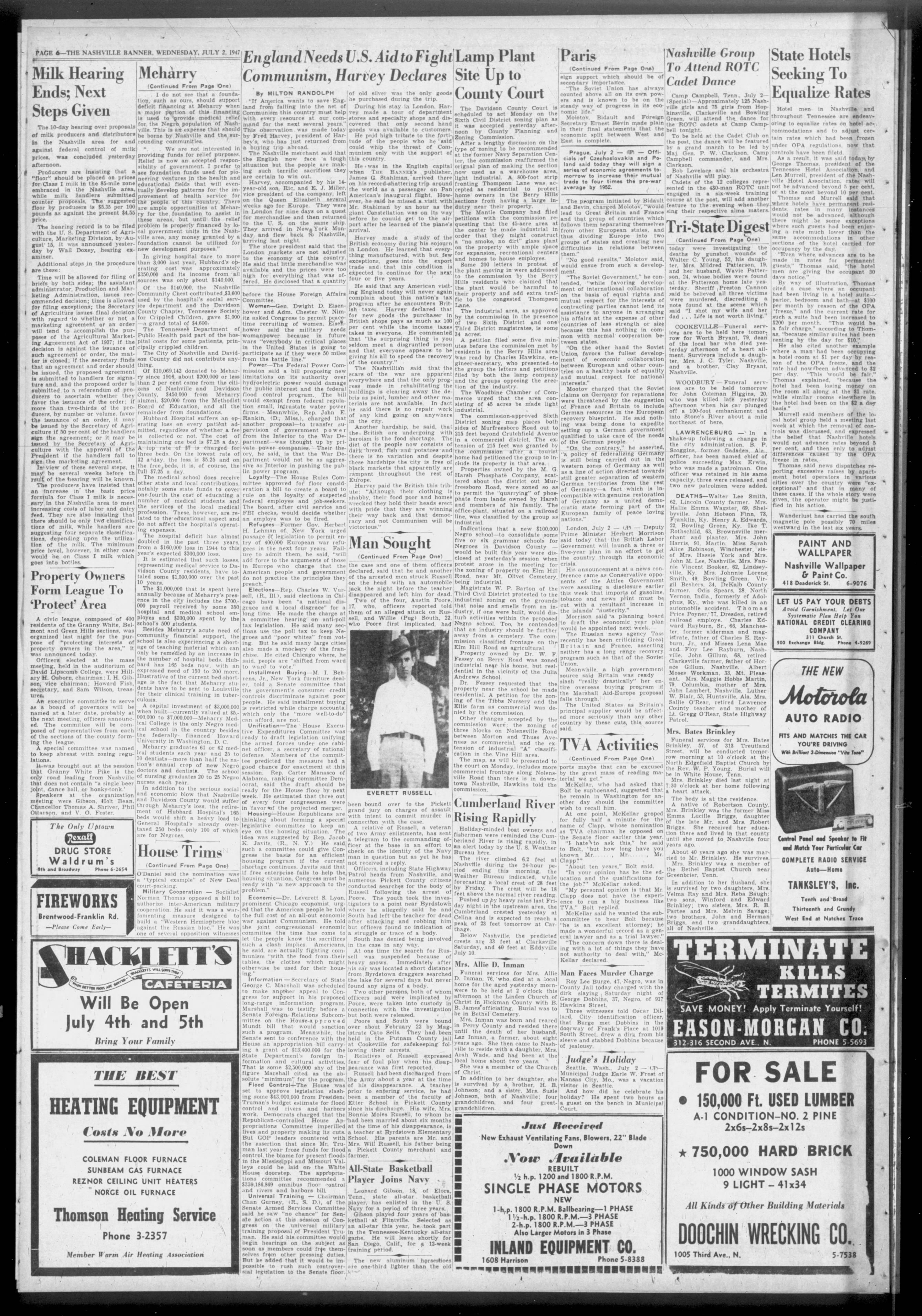
Four hundred residents organized in the Lipscomb auditorium on July 1, 1947
The Banner reported it the next afternoon:
“A civic league, composed of 400 residents of the Granny White, Belmont and Green Hills sections, was organized last night for the purpose of ‘protecting interests of property owners in the area,’ it was announced today.”
Officers elected at the mass meeting were Hillary H. Osborn, chairman; I. H. Gibson, vice chairman; Howard Fish, secretary; and Sam Wilson, treasurer. An executive committee to serve as a board of governors, drawn from each section in the league, was to be named at a later meeting.
The organizing geography — “Granny White, Belmont and Green Hills sections” — covers the area of today’s proposed Green Hills East Neighborhood Conservation Zoning Overlay. A civic league of property owners is the unit Long and Johnson were anatomizing nationally that same year: the neighborhood-improvement association whose original civic functions had, by the 1940s, been subordinated to racial exclusion as the controlling motive.
The meeting was called to weigh a utility district — “a separate corporation … comparable to Belle Meade”
The league was the meeting’s outcome, not its announced business. On the morning of July 1, the Tennessean previewed the evening’s gathering under the headline “New Utility District Talks Slated Tonight,” and the purpose it described was municipal:
“The possibility of creating a utility district for the Granny White, Belmont and Green Hills sections will be discussed tonight at a mass meeting in the auditorium at David Lipscomb College. … Gibson said if the utility district was established it would result in the creation of a separate corporation for the sections involved which would be comparable to Belle Meade. … Taxpayers at the meeting also would discuss zoning, Gibson said.”
The sponsor was I. H. Gibson, identified by the Tennessean as a realtor at 4101 Belmont Boulevard — the same Gibson the Banner would list the next afternoon as the league’s vice chairman and one of its five speakers. He set the meeting for eight o’clock and expected five hundred property owners; the Banner put the league that formed at four hundred. What Gibson proposed was a government. A utility district, he said, “would result in the creation of a separate corporation … comparable to Belle Meade” — the wealthy enclave west of the city that had incorporated as its own municipality in 1938 and written its own zoning. The comparison was Gibson’s own. Belle Meade was the standing Nashville example of a white residential district that had walled itself off behind a municipal charter and a land-use code of its own making, beyond the reach of the city’s zoning politics.
The Banner’s report records no utility district and no separate corporation — only the league and its zoning committee. Gibson had hedged from the start: he told the Tennessean that “the matter had not been decided definitely” and that the night’s talk “would be limited to preliminary discussion of what might be done”; he “did not know of any violations of zoning ordinances at present,” but had called the meeting “for a general discussion of the situation as it is now and as it may be in the future.” The separate corporation comparable to Belle Meade did not materialize. The standing committee “to keep abreast with zoning regulations” did. The meeting reached for the maximal form of self-governing exclusion and settled, that night, for the workable one.
The Banner set “Protect” in scare quotes
The headline reads “Property Owners Form League To ‘Protect’ Area.” The body attributed “protecting interests of property owners in the area” to the league’s own announcement, in regular quotes. The scare-quoted headline was a deliberate editorial choice by Nashville’s conservative afternoon daily, whose editors were no reflexive critics of residential exclusion. By flagging “Protect” they marked the word as the league’s framing and kept it out of the paper’s own voice.
The same register runs through the Green Hills record from one decade to the next: “RESTRICTIONS — For Your Protection” in the 1927 marketing; “restrictive covenants as protectors of residential segregation,” as Charles Hamilton Houston put it at Fisk, reported on the Banner’s own page 6 fifteen days after the league meeting; “protective covenants” in the MHZC’s 2025 overlay language. The Banner printed the euphemism and disowned it in the same breath, in 1947.
The league stood up a zoning committee eight days after the Court agreed to hear Shelley, while its own covenant had twelve years left
The Banner recorded it in one line: “A special committee was named to keep abreast with zoning regulations.” That language singles out zoning from any broader civic-improvement agenda. The committee was constituted on July 1, 1947 — eight days after the Supreme Court, on June 23, granted certiorari in Shelley v. Kraemer (331 U.S. 803), agreeing to decide whether a state court could enforce a racial covenant consistent with the Fourteenth Amendment. A certiorari grant is the moment a constitutional question stops being academic and becomes one the Court will answer; with it, the central vulnerability of the covenant regime passed from a lawyers’ worry into a case with a docket number. Charles Hamilton Houston was preparing the District of Columbia companion, Hurd v. Hodge; Long and Johnson’s book naming that vulnerability was in circulation in the same city. Property owners whose plat covenants were of record, who read the Banner, and who could turn out four hundred people for a founding meeting did not need the ruling to see that the legal machinery of residential exclusion was now in question. A committee to monitor zoning, stood up in that window, reads as institutional hedging: the next enforcement apparatus going up before the old one came down.
The timeline is exact. The Green Hills Plat 1 covenant ran until January 1, 1960. Shelley was decided May 3, 1948. From July 1947 to May 1948 the covenant remained judicially enforceable; from May 1948 to January 1960 the text stayed on file at the Davidson County Register of Deeds and continued to govern voluntary practice, even where a court could no longer order its enforcement. The league set up its zoning committee inside the narrow window when the old instrument still had legal teeth and the replacement was already being built. The full legal background — Buchanan, Corrigan, Shelley, and the migration of exclusion into design standards and zoning — is set out in the companion brief on Racial Covenants and Shelley v. Kraemer. That brief carries the doctrine; this one carries the Nashville evidence.
The “beer joint, dance hall, or honky-tonk” boast spoke the commercial-invasion code for racial transition
The Banner records: “It was brought out at the session that Granny White Pike is the only road leading from Nashville that does not contain ‘a single beer joint, dance hall, or honky-tonk.’”
The remark was offered as a badge of the area’s desirability — the absence of these establishments was what made the corridor worth protecting. The establishments are not arbitrary. In 1947 Nashville, the beer joint, the dance hall, and the honky-tonk were working-class entertainment venues coded as sites of racial mixing and as the leading edge of the commercial encroachment that white owners treated as the predicate for racial transition; naming the commercial nuisance was the accepted way to name the racial one.
The Murphy Addition homeowners who testified at Nashville’s July 11, 1933 zoning hearing made the same move. They protested filling stations, chain stores, and even “half-eaten ice cream cones, thrown away, [which] draw all the flies and when they have dined they visit our homes” — a complaint that reads as overwrought until set against the period understanding that commercial nuisance depressed adjacent values, invited lower-class and often Black tenants, and so set off the chain of flight and transition. The purpose of zoning, in that fight, was to protect white neighborhoods from commercial invasions and from the racial transition those invasions were thought to bring. Fourteen years later, Granny White Pike’s distinction was the same absence of beer joints and honky-tonks, and the league organized to preserve it. The zoning committee was its instrument.
Long and Johnson, writing the same year from Fisk, had named the move directly. Their survey of forty-five Chicago and Detroit improvement associations found that 86.7 percent would consider it objectionable to have Negroes move into their districts — yet almost none called themselves exclusion organizations; they operated “in the guise of protecting and improving the physical aspects of housing and neighborhoods.” The Green Hills league used the same guise. The Banner’s scare quotes acknowledged it.
The league met in the Lipscomb auditorium — the college whose 1927 trust had written the covenant
The 1927 Green Hills covenants were conveyed through American Trust Company, acting as trustee for David Lipscomb College. The restriction — “Neither said property nor any part thereof shall be aliened or conveyed to persons of African blood or descent and no person of African blood or descent shall be permitted to own or occupy the premises except in the capacity of servants” — ran with the land in every Plat 1 deed until January 1, 1960. Twenty years later, the civic league organized to protect that ground met in Lipscomb’s auditorium.
The same network — the A. M. Burton–Life & Casualty–Lipscomb axis — bound the 1927 trust to the 1947 meeting. The social and institutional geography had held for two decades; what was changing were the legal instruments around which it organized, and the meeting was one of the responses.
Among the five speakers was Holt Bean, owner of the Model Home, whose own deed the covenant still bound
The Banner: “Speakers at the organization meeting were Gibson, Holt Bean, Chancellor Thomas A. Shriver, Phil Ottarson, and V. O. Foster.”
Holt Bean had bought Lot 6 of the Plan of Green Hills in May 1927 — the Tennessean Model Home at 1612 North Observatory Drive — and held it still. The Plat 1 covenant barring “persons of African blood or descent … except in the capacity of servants” ran with his deed and would run until January 1, 1960. By 1947 he sat in the executive ranks of Life & Casualty Insurance Company, A. M. Burton’s firm — the same Burton who had funded the college whose auditorium now held the meeting. The man who owned the house built to sell the subdivision’s lots, his own title still carrying the racial restriction, rose to address the league at its founding — eight days after the Court agreed to decide whether such restrictions could be enforced. The Banner records that he spoke; it does not record what he said. His purchase, the household that kept the house, and the covenant on his title are detailed in the companion brief, Holt Bean: A Life.
I. H. Gibson was the meeting’s sponsor and the league’s elected vice chairman. The Tennessean’s advance placed him as a Nashville realtor at 4101 Belmont Boulevard; it was Gibson who called the meeting, set it for eight o’clock at Lipscomb, and proposed the utility district and the separate corporation “comparable to Belle Meade.” His full name and firm are not established — period Nashville newspaper archives and Tennessee State Library and Archives finding aids return no confirmable expansion of the “I. H.” initials — but his role is now documented on both sides of the meeting: the realtor who convened it and the officer it elected.
Chancellor Thomas A. Shriver sat on the Davidson County Chancery Court — a judicial officer addressing an organizing meeting of white property owners whose covenants were then under constitutional pressure. The Banner gives only his name and title. The same Chancellor Shriver granted a temporary injunction in Kain v. Lewis, a post-Shelley Murphy Addition racial-covenant case, in July 1951; the Chancery roster shows a single Thomas A. Shriver holding Part I continuously from 1940 to 1955, establishing that the 1947 speaker and the 1951 chancellor — who in that capacity moved to enforce a racial covenant — are one man. (Chancery Court of Metropolitan Nashville & Davidson County, “Chancery Court History,” chancellor roster; Tennessee Portrait Project, “Shriver, Judge Thomas A.”)
Phil Ottarson has not been identified beyond the Banner article. The surname is unusual, but a search of reputable digitized sources (newspaper archives, Tennessee General Assembly and Nashville municipal rosters, library-digitized directories) returned no confirmable match; the Banner spelling itself is unverified against a second source.
V. O. Foster has not been identified beyond the Banner article; no confirmable match was found in reputable digitized records.
In the same year, from across the same city, Fisk’s scholars published the definitive indictment of the practice
Herman Long, Associate Director of the Race Relations Department of the American Missionary Association at Fisk, and Charles Johnson, then president of Fisk, published People vs. Property: Race Restrictive Covenants in Housing from the Fisk University Press in 1947. The book set out to show that neighborhood-improvement associations had replaced civic betterment with racial exclusion as their operative purpose:
“In fairness to these groups, it should be pointed out that they do not exist, at least they did not originally, for the primary purpose of racial baiting and exclusion. Many of them arose from altruistic and useful motives, serving the valuable function of neighborhood improvement and beautification, providing a means of neighborhood communication and acquaintanceship, and promoting morale and esprit de corps among the residents of the area. … Nevertheless, it seems apparent that the original function has changed or become subordinate, and in its stead the function of Negro residential exclusion has been substituted as the controlling motive. In the guise of protecting and improving the physical aspects of housing and neighborhoods, the ‘protection of property values’ through maintenance of Caucasian-pure residence areas has come to be a dominant purpose.”
— Long and Johnson, People vs. Property, p. 40
The league meeting is a case study in the substitution Long and Johnson described. The stated purposes — protecting the interests of property owners, monitoring zoning, keeping out beer joints and honky-tonks — are the guise. The Lipscomb venue, the covenants running on the plat books, and the ten-month interval before Shelley are the context that makes the guise legible. The manuscript was reviewed by Z. Alexander Looby, one of Nashville’s first Black city councilmen and the attorney who, in 1951, would argue against post-Shelley racial covenants in the Murphy Addition before the same Chancery Court. The scholarship that named what this league was doing was published across town, the same year.
Fifteen days later, NAACP counsel Charles Hamilton Houston came to Fisk to attack “restrictive covenants”
Houston was lead counsel on Hurd v. Hodge, the District of Columbia companion to Shelley, and was then in active preparation for argument. He came to Fisk in July 1947, to the institute where Long and Johnson were based. His phrasing, per the Banner: “Those who favor restrictive covenants as protectors of residential segregation point to the clause of reciprocity in which those discriminated against can employ the same restriction in their neighborhood, but who cares about being restricted from a ‘ghetto’?”
The two clauses turn the reciprocity defense against itself: the right to exclude in return is worthless to those penned into a “ghetto.” The country’s lead covenant litigator was in Nashville in the weeks between the certiorari grant and the briefing, in the same institutional home as the period’s most important Black scholarly indictment of the covenant regime. Nashville was a node in the national fight, on both sides at once. The Banner covered Houston on page 6 of its July 17 edition — the same page, in the same section of the same paper, that had carried the league’s founding fifteen days earlier. Whatever its editors thought of the question, the paper carried both arguments.
Twenty days after Houston, Belcourt landowners signed a fresh thirty-year racial covenant
Davidson County Deed Book 1512, page 564, dated August 5, 1947, covered the O. B. Hayes Subdivision, Rokeby Addition, on 15th and 14th Avenues South near Belcourt, in the Belmont section to the north of Green Hills; the mutual covenant bound the signers’ properties for thirty years against use, occupation, sale, or conveyance “to any negro or negroes.” The geography is distinct; the date is the argument. The racial-covenant apparatus was being extended in Davidson County in August 1947 — twenty days after the country’s leading covenant litigator told a Nashville audience the practice was indefensible, thirty-three days after the Granny White–Belmont–Green Hills league stood up a zoning committee. The old instrument was being extended at the very moment its replacement was going up. The two projects ran in parallel, in the same county, in the same summer.
The reach for a separate corporation was the favored quarter’s signature move, and its subtext was racial
Gibson’s utility district belongs to a pattern that would define southwest Davidson County for the next decade. In the years after 1947, affluent white sections on Nashville’s southwestern flank — the “favored quarter” anchored by Oak Hill, Forest Hills, Green Hills, and Hillwood — turned to incorporation, chartering their own small municipalities to put local land use beyond the city’s reach. The promoter Ewing Clouse made a career of it, incorporating Berry Hill in 1950, Oak Hill in 1952, and Forest Hills in 1957. Services were rarely the point. The reporting collected in “Affluence and Effluence in the Favored Quarter” documents what these incorporations were for: these communities “rejected the annexation-or-consolidation binary and sought a third way,” one that “valued zoning controls over urban services.” The Oak Hill organizers said plainly that they wanted “to have our own zoning board comprised of citizens in our locality,” and the first act of the Forest Hills commission, “as in the other favored quarter incorporations, was the passage of a zoning code which mandated large lots and prohibited commercial or industrial uses.”
The favored quarter’s program — large lots, no commerce, a zoning board of one’s own — was what the Granny White league had reached for in 1947. Its beer-joint boast spoke the anti-commercial half; Gibson’s “separate corporation … comparable to Belle Meade” named the governing structure, the favored quarter’s signature move five years before Clouse incorporated Oak Hill. Belle Meade, chartered in 1938, was the model all of them followed.
The subtext was racial, and contemporaries said so. An Oak Hill incorporation circular told residents that “the law of preservation should certainly begin with our homes and families.” On the other side of the same politics, the councilman Glenn Ragsdale, pushing to annex the working-class Urbandale section — “uncomfortably close to Hadley Park and other all-Black sections of North Nashville” — argued the city should take it in to capture its votes “to offset the growing Negro vote.” Incorporation walled the favored quarter off from exactly that arithmetic: a separate charter and a large-lot zoning code kept the city’s annexations and its shifting electorate on the far side of the municipal line. Green Hills never got its charter — Clouse’s later pushes to incorporate it failed — and so the section was left with the league’s form of control, organized owners watching zoning, rather than a municipal one. The same form reappears in the 2025 overlay campaign (see From the 1947 League to the 2025 Overlay).
Two contemporaneous newspaper sources cover the meeting — the Tennessean’s morning-of advance and the Banner’s next-afternoon report — and no other Nashville coverage of the July 1, 1947 founding has surfaced; the Tennessean’s own after-the-fact account, if it ran one, and any follow-up in either paper have not been pulled. Three of the four officers, and Ottarson and Foster among the speakers, are unidentified beyond their names; Gibson is now placed by the Tennessean as a realtor at 4101 Belmont Boulevard, though his full name and firm remain unconfirmed. The league’s later history is blank: whether it persisted, filed zoning petitions, or retained Bean, what became of the zoning committee, and whether the utility district Gibson floated was ever pursued — let alone chartered as the separate corporation he likened to Belle Meade — is unrecorded in these sources. The Banner and Tennessean indices for 1947–1955 remain unsearched, and that follow-up coverage is the evidence most likely to convert the institutional-hedging reading from inference into documented sequence. The Shriver–Kain v. Lewis connection is now confirmed by the Chancery Court roster — a single Thomas A. Shriver held Part I from 1940 to 1955, spanning both the 1947 speaker and the 1951 chancellor — though the underlying Kain v. Lewis docket, which would establish the substance of the 1951 injunction beyond the Murphy Addition published record, has not been pulled. The Lipscomb venue is established and confirmed as the institution that held the Plat 1 trust; the tie between the choice of that auditorium and the Burton–Life & Casualty–Lipscomb relationships among the league’s principals rests on the documented structural overlap, and whether the room was chosen with that overlap in mind is not recorded. The month of People vs. Property’s 1947 publication, before or after the July meeting, is unpinned — the HathiTrust record supplies no month, and the Fisk University Press archives have not been searched; the print date bears on whether the organizers could have read the book, and it does not touch the significance of the two events’ co-occurrence in the same city in the same year.
Bibliography
Buchanan v. Warley, 245 U.S. 60 (1917).
Corrigan v. Buckley, 271 U.S. 323 (1926).
Davidson County Register of Deeds, Deed Book 770, pp. 41–42 (Green Hills Plat 1 covenant, 1927).
Davidson County Register of Deeds, Deed Book 1512, p. 564 (O. B. Hayes Subdivision / Rokeby Addition covenant, August 5, 1947).
Long, Herman H., and Charles S. Johnson. People vs. Property: Race Restrictive Covenants in Housing. Nashville: Fisk University Press, 1947.
Nashville Banner. “Property Owners Form League To ‘Protect’ Area.” July 2, 1947, p. 6. Newspapers.com image 603047929.
Nashville Banner. “Segregation Hit, at Fisk Race Institute.” July 17, 1947, p. 6. Newspapers.com image 603048165.
Nashville Tennessean. “New Utility District Talks Slated Tonight.” July 1, 1947, p. 15. ProQuest Historical Newspapers.
Pemberton, Alex. “Affluence and Effluence in the Favored Quarter.” Nashville Scene, February 25, 2025. Extended version.
Pemberton, Alex. “The Last Single-Family House in the Murphy Addition.” Nashville Scene, July 31, 2024. Extended version.
Scanlan, Alfred L. “Racial Restrictions in Real Estate — Property Values Versus Human Values.” Notre Dame Law Review 24, no. 2 (1949): 157–96.
Shelley v. Kraemer, 334 U.S. 1 (1948). Certiorari granted June 23, 1947, 331 U.S. 803.
Suggested Citation
Pemberton, Alex. “The 1947 Property Owners’ Protective League.” Research Brief E5, Veneers of History in Green Hills East. alexaustinpemberton.com/journalism/veneers-of-history/#property-owners-protective-league-1947. Accessed [date].
Sally Carpenter's Documentary Trail
Abstract
Five records preserve Sally Carpenter — one census line and four Nashville city-directory entries — every one generated by the household she served, not by her. They show a Black domestic worker, born around 1902 in Tennessee, enumerated in Holt Bean’s household at 1612 North Observatory in 1930 and traceable in the city directories through 1935, after which she leaves the record entirely. The Green Hills covenant barred persons of African blood or descent from the subdivision, then opened one exception: such persons could be present in the capacity of servants. Carpenter was that exception — admitted under the same clause that barred her from ownership, and recorded only insofar as she served. She is recoverable now only because the Bean household was documented so exhaustively; a household that left fewer traces would have left her none.
Methodology
Census record. The 1930 enumeration of the Bean household (Fifteenth Census, Davidson County, Enumeration District 19-220, Sheet 7A) was verified against the census image. The street-label column was read directly from the image and confirmed as “Observatory Drive.” The Carpenter entry at line 18, dwelling 129, family 135, was transcribed verbatim from the image.
City directory search. Nashville city directories were searched on Ancestry HeritageQuest (U.S., City Directories, 1822–1995, Collection 2469) under the name variants “Sally Carpenter,” “Sallie Carpenter,” “Sallie P Carpenter,” and “Sally P Carpenter,” filtered to Nashville, Davidson County, Tennessee. The search returned four unique entries, for 1930, 1931, 1933, and 1935. Each entry’s indexed metadata — year, address, occupation, Ancestry record ID — was captured. Where the index carried OCR corruption (“507 Hardinc” for “1507 Harding”), the address was corrected against the source scan, not the index.
Negative search and exclusion. One earlier candidate was investigated and ruled out. A “Sallie Pearl Carpenter,” born about January 1897 in Belfast, Marshall County, surfaced in the 1920 census; Belfast is roughly ten miles from Lewisburg, where Holt Bean held property before his 1927 Nashville move. But her trail runs the wrong way: by 1950 she is in Warsaw, Sumter County, Alabama, married, and she dies there in January 1985. Three independent enumerations and the Social Security Death Index put her birth in 1897; the Bean-household census puts Carpenter’s in 1902. The five-year gap holds across every record, and the Belfast woman is a different person.
Coverage gaps. Ancestry HeritageQuest’s digitized Nashville directory collection is not complete for every year between 1930 and 1940. The absence of a Carpenter entry after 1935 may mean she left the directory record or may mean the surviving volumes have a hole; the two cannot be distinguished without a direct check against extant R.L. Polk & Co. Nashville directories for 1936–1940.
Sources
Primary documents
-
1930 U.S. Census (Fifteenth Census of the United States). Tennessee, Davidson County, Civil District No. 7 (Part). Enumeration District 19-220, Sheet 7A. Enumerated April 7, 1930, by Leo L. Boles, Enumerator. Supervisor’s District No. 4. National Archives and Records Administration (NARA), Record Group 29; digitized by FamilySearch.
-
Nashville City Directory, 1930. Ancestry HeritageQuest, U.S., City Directories, 1822–1995, Collection 2469, Record 13264456. Entry: “Sally P Carpenter.” Nashville City Directory, 1930.
-
Nashville City Directory, 1931. Ancestry HeritageQuest, Collection 2469. Entry: “Sallie Carpenter.” Nashville City Directory, 1931.
-
Nashville City Directory, 1933. Ancestry HeritageQuest, Collection 2469, Record 14634460 (image 14634460). Entry: “Sallie P Carpenter, 1507 Harding.” Nashville City Directory, 1933.
-
Nashville City Directory, 1935. Ancestry HeritageQuest, Collection 2469, Record 14124956 (image 14124956). Entry: “Sallie P Carpenter, rear ns Observatory 3 w Belmont blvd.” Nashville City Directory, 1935.
Supporting primary documents
- 1930 U.S. Census, Holt Bean household, verbatim entry. The full 1920–1950 run of Bean-household enumerations is set out in Holt Bean: A Life.
- Plat 1, Covenant 4, Green Hills Subdivision (1927). The deed covenant restricting occupancy by “persons of African blood or descent … except in the capacity of servants.” See Plat 1, Covenant 4: The Racial Covenant in the Green Hills Deeds.
Findings
Sally Carpenter was enumerated in the Bean household in April 1930 as a live-in servant
The 1930 census (ED 19-220, Sheet 7A, dwelling 129, family 135, line 18) records her as: name “Carpenter, Sally”; relation to head “Servant”; race “Negro”; sex “F”; age 28; marital status “Single”; birthplace “Tennessee”; occupation “Maid”; industry “Private Home.” Born, then, around 1902, in the state where she still worked. The household around her on that sheet was Holt Bean (head, white, age 39, Insurance Agent), Salome Bean (wife), Jack Bean (son, age 7), and Carpenter — three names that recur across thirty years of records, and one that does not.
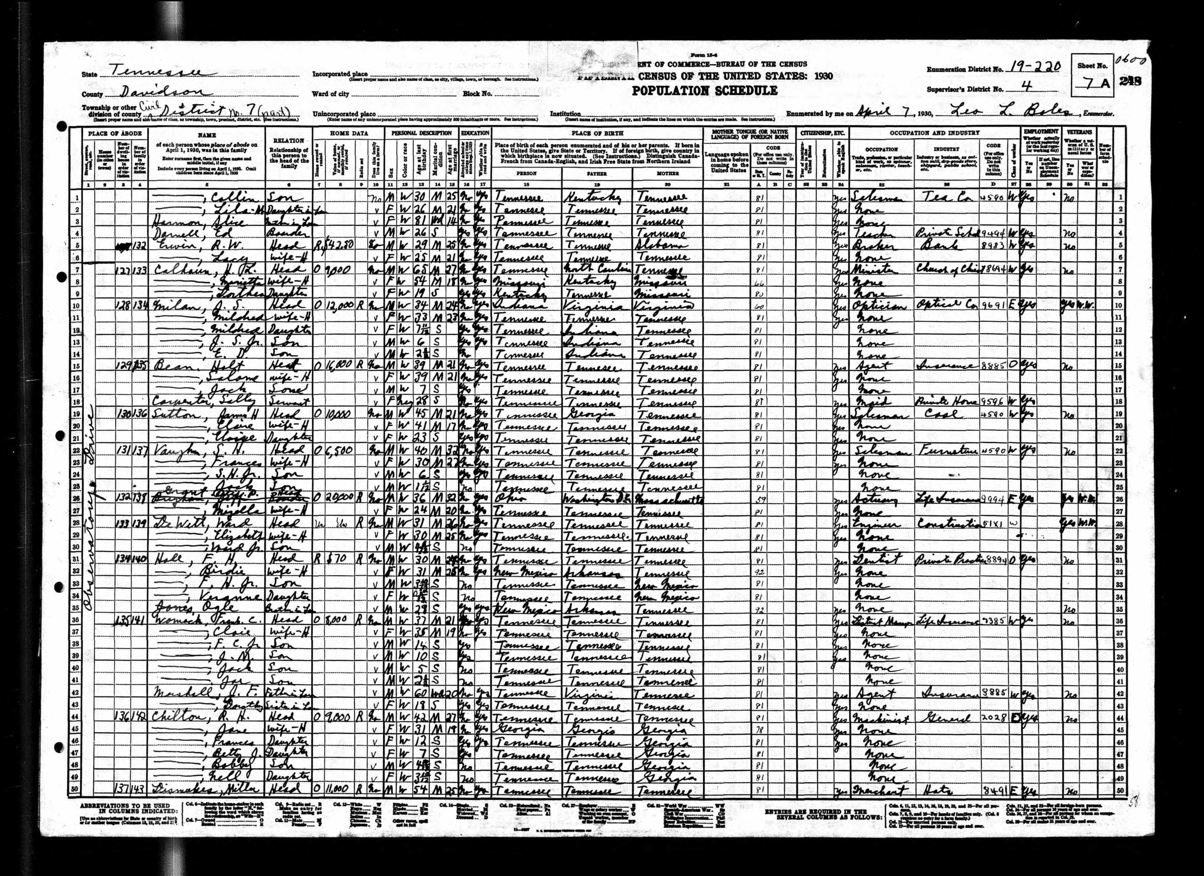
The arrangement was already running well before the 1930 census caught it
The Tennessean’s 1927 architectural coverage of the Model Home specified “a servant’s room and shower” in the basement. The 1930 census places Carpenter in that room — or in the domestic-labor arrangement it was built to house — within three years of the Beans’ purchase. The census fixes no move-in date. By April 1930, though, the deed’s “capacity of servants” clause had become a person, in a basement, with a name.
The middle initial “P” in three of the four directory entries almost certainly stands for Pearl
The 1930 directory indexes her “Sally P Carpenter”; the 1933 and 1935 directories, “Sallie P Carpenter.” Only the 1931 entry drops the initial. The pattern — a middle name used in life, flattened to an initial by a directory typesetter — fits a woman who went by “Sally Pearl” or “Sallie Pearl.” It is the closest the record comes to giving her a name of her own choosing, and even that is an inference.
Four Nashville city-directory entries trace her through at least 1935
The entries, with spellings as indexed:
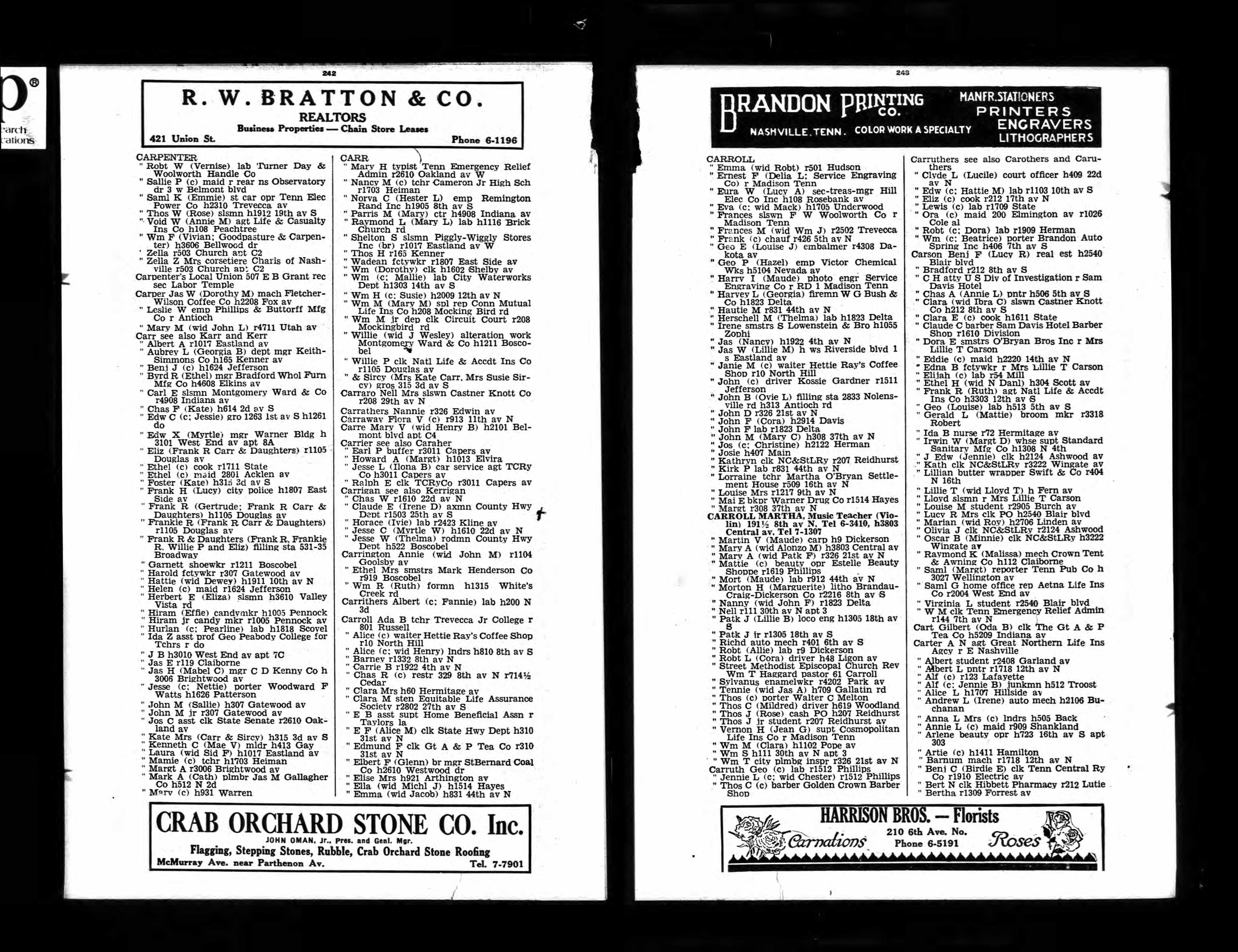
Her address moves across the four records
The 1930 and 1931 entries carry no address of her own; she is indexed under Bean’s. By 1933 she is listed at 1507 Harding, an address that is not his. By 1935 she is back at “rear ns Observatory 3 w Belmont blvd,” the rear of the Bean lot, an outbuilding behind the main house, no longer the basement servant’s quarters inside it. Main house to her own room to a structure out back: the arc is consistent with the informal, shifting residence of live-in domestic labor in segregated Nashville, where the line between living where you worked and living near it was drawn by the employer and redrawn at will.
She does not appear in any record after 1935
The 1940 census of the Bean household (ED 19-264, Sheet 3A) lists only Holt, Salome, and Jack — no servant. No Sally or Sallie Carpenter appears in any Nashville directory consulted after 1935, nor in any other Nashville source examined.
The silence around her is structural
Eight live-in servants are documented across the five target streets of Green Hills East in the 1930 and 1940 censuses: Carpenter, Floyd, Walker, Hamm, Crittenden, Mitchell, McReynolds, Tatum. Not one of the eight appears by name in the Metropolitan Historic Zoning Commission’s 2025 Short History of the neighborhood, a document built from city directories, property records, and accounts that take the homeowner as their subject. The directories indexed the householder; the deeds named the owner; the history followed both. Carpenter is recoverable only because the Bean household was documented so exhaustively. In a household that had left fewer traces, she would have left none.
The post-1935 trail is open. Marriage under another surname would end her appearances under “Carpenter” and would square with her 1930 status — single at twenty-eight, and so thirty-three by 1935 — while death, departure from Nashville, or a move to work outside the indexed neighborhood fit the record equally well; no death record, no marriage record, and no out-of-state enumeration matching her was found, and Davidson County marriage records for 1935–1945 and Tennessee death records of the same span remain unsearched under her name. The 1940 Bean sheet (ED 19-264, Sheet 3A) records no servant, but domestic workers were enumerated inconsistently in this period, and a live-in servant absent on the enumeration date would not appear; the blank line establishes no departure. The Marshall County lead — the Belfast woman ten miles from Bean’s Lewisburg property — was investigated and ruled out: the birth-year gap of 1897 against 1902 holds across four independent records, and her trail runs to Alabama, where she married and died.
Bibliography
Fifteenth Census of the United States, 1930 — Population. Tennessee, Davidson County, Civil District No. 7, Enumeration District 19-220, Sheet 7A. National Archives and Records Administration (NARA), Record Group 29. Digitized by FamilySearch.
Nashville, Tennessee, City Directory, 1930. R.L. Polk & Co. (publisher as indexed). Ancestry HeritageQuest, U.S., City Directories, 1822–1995, Collection 2469.
Nashville, Tennessee, City Directory, 1931. R.L. Polk & Co. (publisher as indexed). Ancestry HeritageQuest, U.S., City Directories, 1822–1995, Collection 2469.
Nashville, Tennessee, City Directory, 1933. R.L. Polk & Co. (publisher as indexed). Ancestry HeritageQuest, U.S., City Directories, 1822–1995, Collection 2469.
Nashville, Tennessee, City Directory, 1935. R.L. Polk & Co. (publisher as indexed). Ancestry HeritageQuest, U.S., City Directories, 1822–1995, Collection 2469.
Metropolitan Historic Zoning Commission. Short History of Green Hills East Neighborhood (Partial draft — Part II, Green Hills East). Nashville: MHZC, 2025. (Internal working document.)
Suggested Citation
Pemberton, Alex. “Sally Carpenter’s Documentary Trail.” Research Brief E6, Veneers of History in Green Hills East. alexaustinpemberton.com/journalism/veneers-of-history/#sally-carpenter-documentary-trail. Accessed [date].
The Servant Households of Green Hills
Abstract
The Plat 1 covenant that governed Green Hills East barred occupancy by anyone of African descent “except in the capacity of servants,” and the federal census shows that exception in constant use. On three streets in 1930 and 1940, enumerators recorded at least eight households that kept a live-in domestic worker, at least four of them Black women. The MHZC’s Short Histories — the neighborhood’s own commemorative document — honors a subset of those same households by the employer’s name and omits every worker. The pattern is structural: the Short Histories were built from city directories and property records, instruments that documented owners and passed over the people who worked in their homes. The commemorative document inherits that silence and reproduces, in the present, the division the covenant drew in 1927.
Methodology
The eight households were reconstructed from the federal manuscript census, not from any index or aggregate. For 1940, every sheet of enumeration district 19-264 (Sheets 3A through 6B) was read directly from high-resolution images of the original schedules. The 1940 form records the street name in a single handwritten column, written once per street grouping and inherited by every line below it until the enumerator writes a new street; each sheet’s street column was isolated and read so that no household was assigned a street by inference from its neighbors. Servant and maid entries were confirmed by reading the name and relationship columns line by line. For 1930, the Bean household on Observatory Drive (ED 19-220) is confirmed verbatim against the sheet; the 1930 Green Hills Drive district (ED 19-226) was not visually re-read and is treated as a floor, not a ceiling. The “at least” in every count is therefore literal.
Sources
Primary documents
- U.S. Census, 1930, Davidson County, Tennessee, ED 19-220, Sheet 7A (Bean household, Observatory Drive). National Archives and Records Administration.
- U.S. Census, 1940, Davidson County, Tennessee, ED 19-264, Sheets 3A–6B (images 00104–00111), covering Observatory Drive, Burton Avenue, Green Hills Avenue/Drive, Eden Avenue, and Bonner Avenue. National Archives and Records Administration.
- Metro Historic Zoning Commission, Short Histories of Green Hills East (draft, “NCZO-TOC-PartII-GHE”), pp. 5–8, profiling Bean, Lackey, and other early residents by name and occupation.
- Green Hills East subdivision, Plat 1, Covenant 4 (“except in the capacity of servants”), treated in the companion brief on the racial covenant.
Scholarship
- Lisa M. Tucker, “The Labor-Saving Kitchen: Sources for Designs of the Architects’ Small Home Service Bureau,” Enquiry: An Open Access Journal for Architectural Research 11, no. 1 (2014): 52–63. A 75-variable analysis of the 99 kitchen designs in the bureau’s first plan book (1921), reading them against Frederick Taylor’s scientific management and the home-economics labor-saving literature, and documenting the bureau’s 1924 partnership with Better Homes in America.
Findings
At least eight households on three streets kept a live-in domestic worker
On Observatory Drive the census records Holt Bean (1930), with Sally Carpenter; John S. Milam (1940), with Mary Floyd; William B. Hunt (1940), with Frances Walker; and Albert Ackerman (1940), with Lillie Hamm. On Green Hills Drive, written “Green Hills Ave.” on several 1940 sheets, Albert Marshall (1940) kept Martha Crittenden, Vaden M. Lackey (1940) kept Minnie Mitchell, and John L. Norton (1940) kept Nettie McReynolds. On Eden Avenue, Otto Jones (1940) kept Lucile Tatum. Each worker is recorded in the household line as “Servant” or “Maid.” Burton Avenue and Bonner Avenue, walked in the same district, show no live-in domestic workers; the pattern concentrates on the three streets named here.
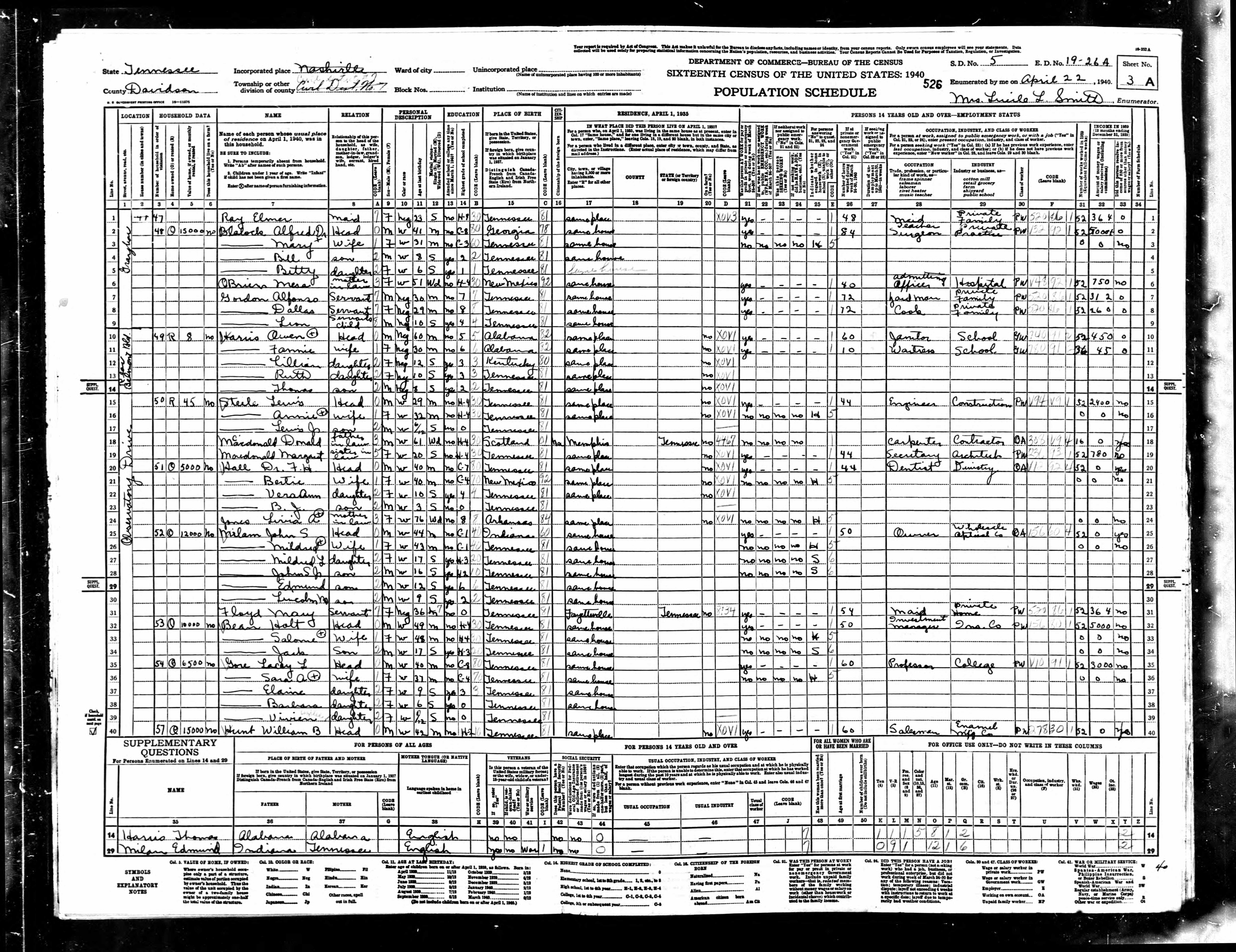
At least four of the workers were Black women
Sally Carpenter (1930, “Negro/F/28/Single/Tennessee”), Martha Crittenden (“Negro/F/32”), Nettie McReynolds (“Negro/F/36”), and Lucile Tatum (“Negro/F/32”) are each recorded “Negro” in legible entries. The count of four is a floor: the race entries for Mary Floyd, Frances Walker, and Minnie Mitchell (ED 19-264, Sheets 3A, 3B, and 5B) are not legible with confidence on the available scans of the schedules, and a sharper scan could push the count higher. Lillie Hamm is recorded white and widowed.
The covenant’s “servants” exception describes a real and recurring arrangement
Plat 1 Covenant 4 barred occupancy by persons of African descent “except in the capacity of servants.” The census shows the exception in use: a Black woman living in the home of a white owner, on a street where the deed forbade her to live in any other capacity. The Bean model home makes the design literal — the Short Histories note that its basement held “a servant’s room and shower,” and the 1930 census places Sally Carpenter in the household that occupied it. The clause named a household structure these blocks actually had; a form deed’s stock language would not have produced so exact a fit.
The model home that opened the subdivision belonged to a movement then redesigning the kitchen itself. The home-demonstration campaign promoted the “labor-saving kitchen,” the room reorganized as a workstation on Frederick Taylor’s scientific-management principles — the routes for preparing and clearing a meal separated, the worker’s steps counted and cut. The Architects’ Small House Service Bureau had built that arrangement into its plans from its first plan book of 1921, and by 1924 it was the credited designer of the houses the campaign celebrated (Tucker, 2014). A kitchen so arranged rationalized the labor of whoever worked it; in the Bean household, that worker was Sally Carpenter.

A subset of these same households appears in the MHZC Short Histories, honored by the employer’s name
The Short Histories profile Holt Bean at length — his model home, his insurance career, his death in 1960 — and list Vaden and Mildred Lackey by their coal company among early Green Hills Drive residents. Both households kept a live-in worker; both appear on the neighborhood’s honor roll. Five of the eight householders — Hunt, Ackerman, Marshall, Norton, Jones — appear nowhere in the Short Histories, by name or fragment, on a full-text check. The Bean and Lackey households are the “at least two.”
None of the eight workers is named in any Short History
All eight servant names were checked against the full text of the Short Histories; none appears, in full, as a variant, or as a surname fragment. The omission is structural: the Short Histories are built from city directories and property records, which document the owners while passing over the people who worked in their homes. The commemorative document inherits the silence of the records on which it rests and reproduces, in the present, the division the covenant drew in 1927. The household that is honored and the household that is omitted are frequently the same house. The Short History names the man whose name was on the deed and omits the woman the deed permitted only as a servant.
The 1930 Green Hills Drive district (ED 19-226) was not visually re-read, so any servant households enumerated there fall outside the eight, and the figure stands as a floor. The 1940 street assignments for several households are approximate, read from the house-number column and not yet confirmed against a 1940 city directory. Neither gap reaches the finding it would have to overturn: at least eight servant-keeping households on these three streets, at least four Black women among the workers, and a commemorative record that honors a subset of the employers while naming none of the people who worked in their homes.
Bibliography
Metro Historic Zoning Commission. Short Histories of Green Hills East. Draft, “NCZO-TOC-PartII-GHE.” Nashville: Metro Historic Zoning Commission, n.d.
Tucker, Lisa M. “The Labor-Saving Kitchen: Sources for Designs of the Architects’ Small Home Service Bureau.” Enquiry: An Open Access Journal for Architectural Research 11, no. 1 (2014): 52–63.
U.S. Bureau of the Census. Fifteenth Census of the United States, 1930. Davidson County, Tennessee, Enumeration District 19-220. Washington, DC: National Archives and Records Administration.
U.S. Bureau of the Census. Sixteenth Census of the United States, 1940. Davidson County, Tennessee, Enumeration District 19-264, Sheets 3A–6B. Washington, DC: National Archives and Records Administration.
Suggested Citation
Pemberton, Alex. “The Servant Households of Green Hills.” Research Brief E7, Veneers of History in Green Hills East. alexaustinpemberton.com/journalism/veneers-of-history/#servant-households-green-hills. Accessed [date].
Selling the Restricted Suburb: How Green Hills Was Marketed
Abstract
Green Hills was advertised in 1927 with its deed restrictions as the second selling point, ahead of price, paired in display type with the word “protection.” A companion ad promised buyers “the sort of people you’d like as neighbors today as well as tomorrow” in the same breath as rising values. The two-word formula — “restricted” and “protection” — was already in national circulation: J.C. Nichols had used it in Kansas City by 1908, and the National Association of Real Estate Boards had written the underlying logic into its 1924 code of ethics as a professional duty. The Green Hills realtors were credentialed by that same body, and the deed they advertised barred sale or occupancy by persons of African descent. Neither ad named what the restrictions were; the recorded covenant carried the rest.
Sources
Primary documents
- Nashville Tennessean, April 6, 1927, p. 3, Green Hills display ad (“NEVER AGAIN … RESTRICTIONS — For Your Protection”), placed by Benz Realty Co., Bolling & Hinrichs, G.A. Maddux & Co., and A.P. Martin & Son. ProQuest Historical Newspapers, doc. 1898671154.
- Nashville Tennessean, April 10, 1927, p. 68, Green Hills sales ad (“the sort of people you’d like as neighbors today as well as tomorrow”). ProQuest Historical Newspapers.
- Nashville Tennessean, January 23, 1927, p. 9, Benz Realty Co. classified (“A HOME FOR THE DISCRIMINATING … in a restricted location, where you have protection from inferior and poorly built homes”). ProQuest ID 1898671700.
- Nashville American, June 4, 1905, full-page Murphy Land Company advertisement (“high class restrictions”; “Don’t forget that the value of real estate is determined by the restrictions placed on it”). Reproduced in Pemberton, “The Last Single-Family House in the Murphy Addition.”
- National Association of Real Estate Boards, Code of Ethics, Article 34 (adopted 1924).
- J.C. Nichols Company advertisement, Kansas City Sun, c. 1908 (“1,000 Acres Restricted for Those Who Want Protection”).
Scholarship
- William S. Worley, J.C. Nichols and the Shaping of Kansas City: Innovation in Planned Residential Communities (Columbia: University of Missouri Press, 1990).
- Sara Stevens, “J.C. Nichols and the Country Club District: Suburban Aesthetics and Property Values,” The Pendergast Years (Kansas City Public Library digital history project), drawing on Stevens, Developing Expertise: Architecture and Real Estate in Metropolitan America (New Haven: Yale University Press, 2016).
- Herman H. Long and Charles S. Johnson, People vs. Property: Race Restrictive Covenants in Housing (Nashville: Fisk University Press, 1947).
Findings
The Green Hills sales argument led with restriction, in display type, paired with the word “protection”
The April 6, 1927 Tennessean ad reduced the subdivision to a four-point pitch, placed by all four of Calhoun’s authorized realtors: “LOCATION — The Best; RESTRICTIONS — For Your Protection; PRICE — Assures Unequaled Value; TERMS — To Suit You.” Restriction is a feature here, ranked above price. “Restrictions” names the legal instrument — the bundle of covenants recorded at Davidson County Book 770, pp. 40–42, which includes setback minimums, a cost floor, a livestock ban, and, as Covenant 4, the bar on occupancy by “persons of African blood or descent … except in the capacity of servants.” “For Your Protection” names what the buyer is told he receives. The ad does not list what the restrictions are. It gives them a purpose and a beneficiary and leaves the recorded deed to carry the rest.
“The sort of people you’d like as neighbors” said what the ad could not print
The April 10, 1927 ad promised that “Green Hills is attracting the sort of people you’d like as neighbors today as well as tomorrow,” in the same breath as “Values here will rise quickly. That’s certain.” The two promises were one: the ad sold the right neighbors as the reason the value would rise. Long and Johnson, writing from Fisk University in 1947, argued that under the cover of protecting “the physical aspects of housing,” the period’s real-estate selling had made “the protection of property values through maintenance of Caucasian-pure residence areas … a dominant purpose.”

The formula came from J. C. Nichols’s Kansas City
Nichols’s Country Club District in Kansas City was the canonical model of the restricted suburb, and the phrase the Green Hills realtors used was his. By 1908, having assembled over a thousand acres, Nichols advertised in the Kansas City Sun: “Have You Seen the Country Club District? 1,000 Acres Restricted for Those Who Want Protection.” A company brochure carried the same logic — “In the Country Club District you are given the protection that goes with ‘a thousand acres restricted.’” The pairing of “restricted” with “protection” that appears in the 1927 Green Hills ad is the 1908 Nichols formula in its essential terms. Nichols’s innovation, as Worley documents, was to sell deed restrictions as a guarantee of what a buyer would receive: paved streets, sewers, landscaped commons, and, by self-perpetuating covenant enforced through the homeowners’ association he is credited with inventing, the permanence of all of it. Stevens summarizes the pitch: Nichols treated real estate as “unstable merchandise” and advertised restrictions as “protection against market instability.” The racial-exclusion clause rode inside that promise of stability, sold as one more guarantee against loss.
The realtors’ own 1924 code made restriction a professional duty
Article 34 of the National Association of Real Estate Boards’ 1924 Code of Ethics instructed that “a Realtor should never be instrumental in introducing into a neighborhood a character of property or occupancy, members of any race or nationality, or any individuals whose presence will clearly be detrimental to property values in that neighborhood.” This was the governing norm of the trade, in force from 1924 to 1950. It converted exclusion from a developer’s preference into the ethical standard of the profession: a Realtor who sold across the color line risked sanction. The word “Realtor” was itself NAREB’s trademark, and the Green Hills ad places it in quotation marks beside each broker — “Or Call Any of the Following ‘Realtors.’” The men selling Green Hills were credentialed by the same body whose code made racial restriction a duty. W.H. Maddux, of G.A. Maddux & Co., one of the four firms on the ad, was president of the Nashville Real Estate Board, the local NAREB chapter, and attended the Model Home groundbreaking in December 1926. The code’s authors and the ad’s signatories belonged to the same professional network.
Nashville had been speaking this language since 1905, and the trade press kept teaching it
The Murphy Land Company’s full-page Nashville American ad of June 4, 1905 touted the subdivision’s “high class restrictions” and instructed readers: “Don’t forget that the value of real estate is determined by the restrictions placed on it and the character of improvements that surround it.” The Murphy Addition was marketed as a “suburban park” — a precursor to Nichols’s “residential park” framing — with deed restrictions banning Black residence sold as part of its appeal. Twenty-two years later the pitch had been refined: Benz Realty Co., one of the four Green Hills realtors, ran a January 23, 1927 classified headlined “A HOME FOR THE DISCRIMINATING,” promising a home “in a restricted location, where you have protection from inferior and poorly built homes.” The headline does the class-and-race signaling; the body narrows the named threat to “poorly built homes.” The Green Hills display ad performs the same substitution at larger scale: name a respectable threat (instability, inferior construction), let “restricted” and “protection” gesture at the rest. The vocabulary was reinforced continuously through the trade and federal channels the Tennessean’s real-estate pages carried — the Department of Commerce’s Better Homes homebuying checklist pairing “protection offered to homes” with “private restrictions, zoning ordinances,” and NAREB’s 1925 convention agenda item on “the zoning of cities as a protection of real estate values.”
The ad sold the restriction to the buyer as a benefit
A deed restriction limits what the buyer himself may do with his land. It also limits what his neighbors may do with theirs, because the same covenants run with every lot in the subdivision. The Green Hills ad pointed to the second effect. “RESTRICTIONS — For Your Protection” told the buyer that the rules binding him would bind everyone around him, and offered that as the thing he was paying for. The racial covenant was one of those rules, and the buyer would be on its protected side.
The advertisements show how the property was pitched, not which restriction an individual buyer was answering — the racial clause, the cost minimum, or the setback line. The overlap between the 1908 Nichols slogan and the 1927 Green Hills copy — the same pairing of “restricted” with “protection” — is strong, yet no document ties Calhoun or his realtors to Nichols’s published materials directly; the formula traveled through the saturated national trade culture — NAREB, the National Real Estate Journal, the Better Homes movement — with no single documented channel from Nichols’s office to Calhoun’s. The “residential park” framing is documented for Nichols and for the Murphy Addition’s “suburban park,” but whether Green Hills’ own copy reached for comparable park language beyond “The Plateau Overlooking The Knobs” remains unsettled across the fuller 1927 ad run. The restricted suburb as a recognizable type — its places, its peer network, its self-image — is treated in The Restricted Suburb: Nashville and Its National Peers.
Bibliography
Long, Herman H., and Charles S. Johnson. People vs. Property: Race Restrictive Covenants in Housing. Nashville: Fisk University Press, 1947.
National Association of Real Estate Boards. Code of Ethics, Article 34. Chicago: NAREB, 1924.
Nashville American. “Murphy Addition” advertisement. June 4, 1905.
Nashville Tennessean. Benz Realty Co. classified advertisement, “A Home for the Discriminating.” January 23, 1927, p. 9. ProQuest Historical Newspapers, doc. 1898671700.
Nashville Tennessean. Green Hills display advertisement, “Never Again … Restrictions — For Your Protection.” April 6, 1927, p. 3. ProQuest Historical Newspapers, doc. 1898671154.
Nashville Tennessean. Green Hills sales advertisement, “Nashville’s Fastest Selling Subdivision.” April 10, 1927, p. 68.
Stevens, Sara. Developing Expertise: Architecture and Real Estate in Metropolitan America. New Haven: Yale University Press, 2016.
Stevens, Sara. “J.C. Nichols and the Country Club District: Suburban Aesthetics and Property Values.” The Pendergast Years. Kansas City Public Library. Accessed May 29, 2026.
Worley, William S. J.C. Nichols and the Shaping of Kansas City: Innovation in Planned Residential Communities. Columbia: University of Missouri Press, 1990.
Suggested Citation
Pemberton, Alex. “Selling the Restricted Suburb: How Green Hills Was Marketed.” Research Brief E8, Veneers of History in Green Hills East. alexaustinpemberton.com/journalism/veneers-of-history/#marketing-the-restricted-suburb. Accessed [date].
Not a Middle-Class Home: The $12,250 House in 1930 Nashville
Abstract
The MHZC grounds Green Hills East’s significance in the Better Homes in America movement and treats the Tennessean Model Home as the movement’s local example of ordinary homeownership. At $12,250 — the consideration the recorded deed states — it exceeded the average White-owned home in every one of Nashville’s forty census tracts, the city’s most valuable included; the weighted citywide White average was $5,963. A historian of the Better Homes movement describes the demonstration homes as upper-middle-class or above, the “every man’s home” framing a fiction the design carried. The house held a basement servant’s quarters with a live-in Black domestic worker admitted to the subdivision only under the covenant’s exception for servants. The same deed barred Black ownership, and the census tract that averaged closest to the model home’s price recorded no Black-owned homes at all.
Findings
The house out-priced every tract and ran on a servant’s labor
Holt Bean paid $12,250 for the Tennessean Model Home in 1927, on a deed that barred “persons of African blood or descent … except in the capacity of servants.” The house had a basement servant’s quarters; the 1930 census records a Black domestic worker, Sally Carpenter, in the household. The MHZC grounds the district’s national significance in the Better Homes in America movement and its promise of ordinary homeownership, but the price and the servant arrangement put the house above the class the framing claimed.
Benjamin: the “middle-class” label was the movement’s own marketing
Karen Benjamin, in an interview, says the program sold its demonstration houses as “every man’s home… something that anyone who works hard can attain. And that wasn’t true. The demonstration homes often sold for, at the time, $10,000 or more, which was a lot of money for a house, so you’re already hitting this kind of upper-middle-class level or above.” She compares the effect to “the middle-class home on a TV show — something that is not affordable to your average, even upper-middle-class family… these were actually really expensive homes.” The design carried “this fiction that this is actually for a middle-class home.” By her own measure — $10,000 or more in the 1920s — the Tennessean Model Home, at $12,250, sat in the upper-middle-class range or above.
At $12,250, the model home cost more than the average home in any Nashville tract
The 1930 Census supplies the citywide comparison. Weighted across the forty Nashville tracts, the average White-owned home was worth $5,963 and the average Black-owned home $2,176 — a White average 2.74 times the Black. At $12,250 the Bean home cost 2.05 times the White average and 5.63 times the Black. The sharper measure is the ceiling. No tract in the table averaged more than tract 0021, at $12,166 across 694 White-owned homes; the next were tract 0012 ($10,749) and tract 0013 ($10,532). The model home, at $12,250, cost more than the average White-owned home in every one of the forty tracts, the most valuable included. Green Hills itself sits south of that map — newly platted on the city’s fringe in 1927, beyond the tracts the 1930 Census drew — so the price is measured against the most valuable neighborhoods Nashville then had, and it topped them.
White households owned more often and held nine-tenths of the value
White Nashvillians owned their homes at 41.6 percent, Black Nashvillians at 28.5 percent. Among owners, Black households held 23.5 percent of the White-and-Black owned units but only 10.1 percent of their combined value: $7.5 million against $67.5 million. The model home was a high-value White holding in a market where Black ownership was both less common and worth far less.
The most valuable tracts excluded Black ownership — the line the Green Hills covenant drew
Nashville’s two highest-value tracts recorded no Black-owned homes at all: tract 0021 (694 White-owned, $12,166) and tract 0020 (1,131 White-owned, $8,489). Tract 0012 ($10,749) held one Black-owned home; tract 0022 ($9,607) held two. Where high White value and Black ownership did meet, the gap inside the tract was steep — tract 0013 averaged $10,532 for 356 White-owned homes and $2,121 for 99 Black-owned, a 4.97-to-1 ratio. The exclusion visible in those counts is the same line the Green Hills deeds drew by covenant: Black residents barred from owning, admitted only as servants. The model home stood at the top of that distribution and inside that rule.
How the figures were computed
The values come from IPUMS NHGIS, dataset ds65_1930_tract, the 1930 Census tract-level housing tables. Filtering to STATEA = 47 (Tennessee) and COUNTYA = 037 (Davidson County) returns the forty Nashville tracts. The brief uses owned-home counts BNS001 (White) and BNU001 (Black), average owned-home values BNV001 (White) and BNZ001 (Black), and total-home counts BNR001 (White) and BNT001 (Black) for the tenure rates. The 1930 Census category “Negro” is kept only where a field universe is named.
The citywide averages are weighted means, not averages of the tract averages:
- White:
sum(BNS001 × BNV001) / sum(BNS001)= $5,963.19, over 11,319 owned units. - Black:
sum(BNU001 × BNZ001) / sum(BNU001)= $2,176.18, over 3,469 owned units; the five tracts with no Black ownership add nothing.
Weighting matters because the highest-value White tracts were also the largest, so the weighted White average ($5,963) runs above the unweighted mean of tract averages ($5,322). The Bean ratios follow: 12,250 / 5,963.19 = 2.05, and 12,250 / 2,176.18 = 5.63. The tract ceiling is the single highest White-owned tract average in the table, tract 0021 at $12,166; $12,250 exceeds it.
The Census counted owner-occupied homes only, and the 1930 value was the owner’s own estimate, not an appraisal or sale price; its bias is unknown and may differ by race. And the tract table maps the incorporated city: Green Hills, unincorporated and newly subdivided in 1927, is not one of the forty tracts, so the comparison is to the city’s tracts rather than to a Green Hills tract, which the 1930 table does not provide. To reproduce the figures, pull the ds65_1930_tract extract from nhgis.org, filter to the forty Davidson County tracts, and compute the two weighted means, the two ratios, and the maximum tract average.
Sources
1930 home values. IPUMS NHGIS, dataset ds65_1930_tract (1930 Census, tract-level housing tables), filtered to the forty Davidson County (Nashville) tracts. Full citation in the Bibliography. All averages, ratios, tenure rates, value shares, and the per-tract figures are computed from this extract.
Purchase price: $12,250 (May 1927). Davidson County Register of Deeds, Book 919, p. 110 — the Haile-to-Bean conveyance of Lot 6, Plat 1, reciting a $12,250 consideration. The Nashville Tennessean of May 16, 1927 gave a rounded $12,000, which the Metropolitan Historic Zoning Commission, A Short History of Green Hills East NCZO, Part II (2025), p. 5, repeated. The deed is the primary record.
Better Homes in America. Karen Benjamin, Good Parents, Better Homes, and Great Schools (UNC Press, 2025), and Benjamin’s account of the movement’s middle-class framing in an interview with the author, May 18, 2026. The model home’s servant household is documented in the Sally Carpenter and servant households briefs.
Bibliography
Jonathan Schroeder, David Van Riper, Steven Manson, Katherine Knowles, Tracy Kugler, Finn Roberts, and Steven Ruggles. IPUMS National Historical Geographic Information System: Version 20.0 [dataset]. Minneapolis, MN: IPUMS. 2025. Dataset ds65_1930_tract (1930 Census, tract-level housing tables), Davidson County, Tennessee.
Benjamin, Karen. Good Parents, Better Homes, and Great Schools. Chapel Hill: University of North Carolina Press, 2025. [Cited for the movement’s middle-class framing; supplemented by an interview with the author, May 18, 2026.]
Suggested Citation
Pemberton, Alex. “Not a Middle-Class Home: The $12,250 House in 1930 Nashville.” Research Brief E9, Veneers of History in Green Hills East. alexaustinpemberton.com/journalism/veneers-of-history/#1930-home-values-method. Accessed [date].
The Sources of the Short History: A Historiographical Critique
Abstract
The MHZC’s Short History of Green Hills East builds the district’s significance almost entirely from the promotional record of the people who built and sold the neighborhood. Twelve of its fifteen footnotes are contemporaneous newspaper clippings, eleven from the Tennessean, the model home’s own sponsor, and the claim to national significance rests on a single mail-order house-plan catalog. The history cites no scholarship and no recorded deed. The missing deed work is the source of its central error — the model home at the wrong address — and it is why the history never sees the racial covenant printed on the same deed page as the cost minimum it does cite. The document reproduces the 1927 sales vocabulary as its own narrative voice and reads the neighborhood as a roster of notable men, in a mode of preservation history that the field spent the last half-century correcting.
Methodology
The text was read from the MHZC document filed in the December 17, 2025 hearing record (A Short History of Historic Green Hills East). Every numbered footnote and every figure-source credit was tabulated and classified by publication and by source type: contemporaneous newspaper, promotional or movement literature, secondary scholarship, recorded deed or plat, map, oral testimony, or government record. The two image-dependent claims — the content of the advertisement the commission clipped as its Figure 1, and the form of the Tennessean sketch map at its Figure 9 — were verified by direct inspection of the document’s own page images against the underlying public-domain 1927 Tennessean originals. Each factual claim of consequence was checked against the corresponding primary instrument established in the companion briefs: the recorded deeds, the plats, and the federal census. Direct quotations are cited in the notes.
Sources
The document under review
- Metropolitan Historic Zoning Commission, A Short History of Historic Green Hills East. Submitted in support of the proposed Green Hills East Neighborhood Conservation Zoning Overlay; in the December 17, 2025 MHZC hearing record. Fifteen numbered footnotes; figure credits as cited.
Primary instruments the history does not cite
- Davidson County Register of Deeds, Book 919, page 110 — T. J. Haile Jr. to Holt and Salome Bean (Lot 6, 1612 North Observatory). Recites the recorded purchase consideration of $12,250.
- Davidson County Register of Deeds, Book 770, pages 41–42 — Plan of Green Hills, Plat 1 covenants. Covenant 3 sets the construction-cost minimum (“no residence will be erected on said property which costs less than $5000.00”); Covenant 4 is the racial restriction.
- Davidson County Deed Book 716, page 312 — American Trust Company, Trustee, to Mizella Burton Grant (Lots 12 and 13, 1637 South Observatory), recorded January 12, 1927.
The history’s national-significance source, and the program it describes
- Henry Atterbury Smith, ed., The Books of a Thousand Homes, Vol. I (New York: Home Owners’ Service Institute, 1923). A mail-order house-plan catalog offering several hundred small-house plans with working drawings and specifications for sale; the document’s sole authority for the home-demonstration movement (cited at notes 3, 4, 5).
- Janet Hutchison, “The Cure for Domestic Neglect: Better Homes in America, 1922–1935,” Perspectives in Vernacular Architecture II (1986). Scholarship on the Better Homes movement the history does not consult.
Advertisements (for the coded marketing lexicon)
- Nashville Tennessean, April 10, 1927, p. 68 — the Green Hills “OPPORTUNITY” ad; the source of the commission’s Figure 1.
- Nashville Tennessean, April 6, 1927, p. 3 — the four-point pitch including “RESTRICTIONS — For Your Protection.” ProQuest doc. 1898671154.
- Nashville Tennessean, January 23, 1927, p. 9 — Benz Realty, “A HOME FOR THE DISCRIMINATING … protection from inferior and poorly built homes.” ProQuest doc. 1898671700.
Interview and scholarship
- Karen Benjamin, Good Parents, Better Homes, and Great Schools: Selling Segregation Before the New Deal (Chapel Hill: University of North Carolina Press, 2025); and interview by the author, May 18, 2026.
- Paige Glotzer, How the Suburbs Were Segregated: Developers and the Business of Exclusionary Housing, 1890–1960 (New York: Columbia University Press, 2020).
- Anders Greenspan, Creating Colonial Williamsburg: The Restoration of Virginia’s Eighteenth-Century Capital (Washington, DC: Smithsonian Institution Press, 2002).
- Ned Kaufman, Place, Race, and Story: Essays on the Past and Future of Historic Preservation (New York: Routledge, 2009).
- Max Page and Randall Mason, eds., Giving Preservation a History: Histories of Historic Preservation in the United States (New York: Routledge, 2003).
- Andrew Hurley, Beyond Preservation: Using Public History to Revitalize Inner Cities (Philadelphia: Temple University Press, 2010).
Findings
The history rests on the sellers’ own promotional record
The Short History carries fifteen numbered footnotes. Eleven cite The Tennessean (notes 1 and 6 through 15). One cites the Nashville Banner (note 2). The remaining three (notes 3, 4, 5) cite one book — Henry Atterbury Smith’s The Books of a Thousand Homes, a mail-order catalog that sold several hundred small-house plans with working drawings by post. The case for the district’s national significance — the claim the whole nomination turns on — rests on a sales catalog produced by the movement it credits. The figure credits run the same way. Of the sixteen figures, the Tennessean supplies six, the Banner two, recorded plat books three, and old maps three; the rest come from the Metro Historical Commission’s own files. No footnote and no figure cites a work of scholarship. The document also reproduces three recorded plats (Figures 3, 5, 6) and not one recorded deed. It went to the courthouse for the drawings that show lot lines and skipped the instruments that show owners and restrictions. Of the eleven Tennessean footnotes, ten point to the paper’s promotion of its own model home and subdivision — “The Model Roof for The Model Home,” “Men to Be on Ground Every Day for 5 Weeks to Receive Visitors,” “Tennessean’s Model Home Thrown Open to Throng of 15,000,” “Green Hills Subdivision a Proven Success!”2 The lone gesture toward a secondary source folds back into the paper: “Archivist, Debbie Cox, in her Nashville Blog Post, noted that the Tennessean wrote …”1 The chain of authority collapses to a single interested publisher and a house-plan catalog.
The history treats the sponsor’s copy as a record of fact
The demonstration house was “The Tennessean Model Home.” The home-demonstration program reached the public through newspapers by design, and the Short History says as much: the Home Owners’ Service Institute led the movement “by publishing home plans and information first in the New York Tribune and then through syndication.”1 The Nashville instance carried the sponsoring paper’s name across its front, and the paper ran “Regular full-page articles” on the construction that, in the history’s own words, were “used not only to sell ideas but also materials and home goods.”1 The coverage was a sales vehicle, by the document’s own admission. The history reads it as testimony. It lifts the paper’s copy into its own narrative voice — “perfection in every detail,” “a thing to be admired,” “near perfect as possible for small homes,” “an exclusive neighborhood in which to erect substantial homes”3 — and it carries the paper’s carelessness with the copy. The Beans’ purchase price appears as “$12,000,”1 the Tennessean’s rounded number; the recorded deed states $12,250.4 The paper’s promotional sketch map (below) marks the home at the bend of the horseshoe with no lot numbers, no distinction between North and South Observatory, and only stylized streets. The document adds errors of its own. It misspells the paper as “Tenneassean,” gives the lead institution two different names (“Home Owners Service Institute” and “Homeowners Service Institute, Inc.”), and drops a word (“the first house was enlarge”).1 It also assigns the movement’s founding to a 1923 women’s-club model home, when the campaign had launched in 1922.7 No single slip is fatal. Together they describe a document that reproduced a promotional source without checking it, down to the typography.
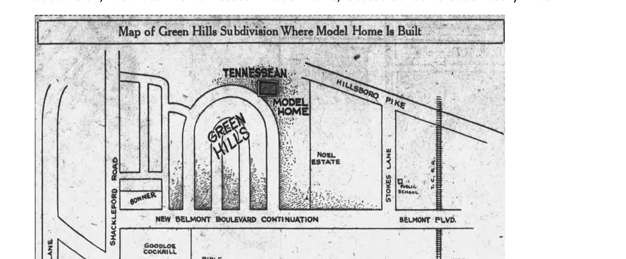
The history read no deeds, and its errors follow
Not one recorded instrument is cited by book and page anywhere in the document. The staff did consult the courthouse: three recorded plats appear as figures. They read the class of land record that shows lots and skipped the class that names owners and carries covenants, and the deeds were a public search away. Four consequences follow.
The central artifact is misidentified. The history places the Tennessean Model Home at “1637 S Observatory Drive (lots 12 and 13).”1 The deeds and the census fix it at 1612 North Observatory, Lot 6, and show that the 1637 lots were privately held by Mizella Burton Grant in January 1927, four months before the model home was sold. The error most likely traces to the promotional sketch map above: a drawing made to sell lots, read onto a parcel on the wrong arm of the horseshoe. The document is internally consistent about it. It always locates the home at 1637 and refers to 1612 only as a place where “the original design can be seen,”1 a surviving copy of the plan. The error is the product of method: significance assigned without reading the chain of title. The proof is laid out in Identifying the Model Home: 1612 North Observatory, Not 1637 South and The Misidentified Lot: 1637 South Observatory and the Burton Cluster.
An oral claim goes uncorroborated. “Longtime resident Lee Maddux says that 3810 Belmont, at the corner of Burton Ave and Belmont, was owned by Burton.”1 The ownership of 3810 Belmont is a matter of recorded deeds. The history reports the recollection and never checks it against them.
Figures come from the paper, not the instrument. The “$5,000 minimum building restriction” is footnoted to “New Subdivision Sells Rapidly,” Tennessean, 6 Feb 1927.1 The recorded covenant states the same figure — “no residence will be erected on said property which costs less than $5000.00” (Book 770, p. 42) — so the number is correct, but the instrument, not the paper, is the authority.5
The racial covenant goes unseen. That cost minimum sits on the same deed page as Covenant 4, the bar on ownership or occupancy by “persons of African blood or descent … except in the capacity of servants.”5 Reading the deed to source the $5,000 figure would have placed the racial covenant directly in front of the author. Sourcing the figure to a newspaper is how it stayed out of the history. The omission reads as a failure of basic historical research, not a proven editorial choice; the question of intent is taken up in Whitewashing the History: The Short History Critique, and the covenant itself in Plat 1, Covenant 4: The Racial Covenant in the Green Hills Deeds.
The history reproduces the marketing’s coded language without examining it
The document repeats the 1927 sales vocabulary as its own. The neighborhood sits on a “plateau that overlooks the knobs,” advertised “Where There is No Smoke or Dirt,”6 sold as a “respite from urban living.”1 In the suburban marketing of the period, elevation, clean air, and distance from the city carried a racial and class meaning: the healthy, ordered suburb set against a city imagined as crowded, dirty, and racially mixed. The historian Karen Benjamin shows how developers “assured buyers that deed restrictions were protective rather than restrictive,”14 and, in an interview for this article, how a “healthier environment” was pitched to parents who would read it as protection for their children.15 The commission’s own Figure 1 is the illustration from the ad — a suited man presiding over a grid of ordered lots beneath the word “OPPORTUNITY” — and the copy printed beside that picture reads “Green Hills is attracting the sort of people you’d like as neighbors today as well as tomorrow,” “Values here will rise quickly. That’s certain,” and “The Plateau Overlooking The Knobs.”8 The commission reproduced the image and engaged none of the words. The campaign’s other advertising was plainer still. Green Hills was sold to “those who want an exclusive neighborhood in which to erect substantial homes” (a line the Short History quotes),1 as “A HOME FOR THE DISCRIMINATING … in a restricted location, where you have protection from inferior and poorly built homes” (Benz Realty, Jan. 23, 1927),9 and under the banner “RESTRICTIONS — For Your Protection” (Apr. 6, 1927).10 In 1920s subdivision advertising “exclusive” and “restricted” were the marketing companions of the racial covenant and the cost floor, and buyers read them as such.11 The developers had used the same words for a generation, from J. C. Nichols’s 1908 “Restricted for Those Who Want Protection” in Kansas City12 to the Murphy Addition’s 1905 “the value of real estate is determined by the restrictions placed on it.”13 The Short History quotes “exclusive … substantial homes” as evidence of neighborhood character and lets the period meaning pass. The lexicon is examined in Selling the Restricted Suburb: How Green Hills Was Marketed and “For Your Protection”: A Protective Lexicon, 1908–2025.
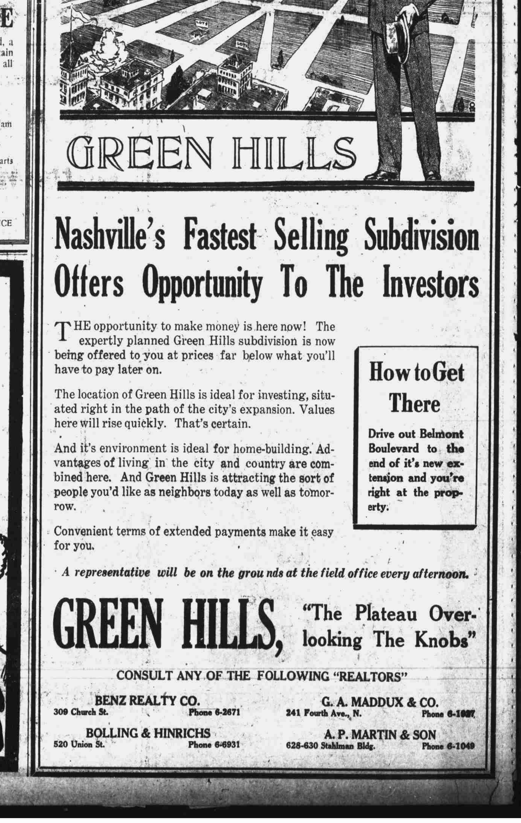
The history fills its gaps with guesswork
Much of what links its facts is speculation. The name Green Hills “may come from” the view of three hills; a marketing tool was “most likely” the origin; Eden Avenue was named “possibly” after the Garden of Eden; “Shriver may have known Bonner, as Mrs. Bonner is listed in 1897 as receiving a free gas cook stove from the Nashville Gas Co.”1 The name-origin passage — a poem of the 1800s, an 1829 song, a 1920s opera — is speculative etymology with no bearing on the district’s significance. Speculation has a place in historical writing, marked as such and bounded by what the records can and cannot show. The Short History supplies the hedges and skips the reckoning: it strings the guesses into a continuous story and never tests them against the record, and the result is folk history.
The method is the old preservation of great houses and great men
The “Short Histories by Street” section is a register of first residents and their employers, and it foregrounds notable men: Judge Thomas Shriver, chancellor and appellate judge and gas-company founder; Andrew Mizell Burton, “the founder of Life and Casualty Insurance Company,”1 with an avenue named for him. The section records who lived on each street and what each man did for a living. It does not ask who was kept out, who worked in the houses, or how the neighborhood was assembled. American preservation began the same way. Its first national body, the Mount Vernon Ladies’ Association, was founded in 1853 to save a founding father’s estate, and its formative restoration, Colonial Williamsburg, was rebuilt with Rockefeller money beginning in 1926 as an idealized eighteenth-century capital, and for decades it left the enslaved people who were about half the colonial town out of its public story.16 The Short History performs the same operation a century later. It restores the judges and the insurance founders and leaves out the servants in the basements and the covenant on the deeds. The field has spent fifty years correcting that paradigm. Ned Kaufman faults a preservation that saved buildings for their form, their style, or the pedigree of their architects, and argues for protecting “storyscapes,” the places that carry a community’s history.17 The same critical turn runs through the field’s recent historiography.18 The correction is now institutional, and it reached Nashville. The National Park Service’s Underrepresented Communities program, begun in 2014, funds states and cities to document the histories the national register long left out, and the Metro Historical Commission — the body whose staff produced this history — won one of its grants. The commission used the grant to document Nashville’s mid-twentieth-century Black neighborhoods, and the Short Histories that resulted, for Haynes Heights, Haynes Manor, and Lathan-Youngs, name race openly and at length.19 The commission has written inclusive history. It has kept the practice on one side of the color line. The grant paid for a full racial accounting of the neighborhoods built under Jim Crow for Black residents, while the white-neighborhood histories, Green Hills East among them, were drafted in-house with no such charge and the racial content of their own deeds left out. Across the commission’s overlay histories, the four Black-neighborhood accounts carry 178 of the 193 race-language mentions, and the historically white neighborhoods — including those whose founding deeds barred Black ownership — carry almost none, as Counting the Silence: Race-Language Asymmetry in the Short Histories sets out. The Short History was filed in 2025, by a commission that had done the inclusive work elsewhere and brought none of it here.
The richer history was already in the document’s own materials
The method missed an account a sound one would have found, and the evidence for it sits in the staff’s own pages. The resident lists name a cluster of Life and Casualty Insurance figures — A. M. Burton, the company’s founder, with an avenue named for him; “Frank C. and Cloie Womack (Dist Mgr L&C Insurance Co.)” on Observatory Drive;1 Otis P. Grant, Burton’s son-in-law — and Holt Bean, who bought the model home, rose to executive at the same firm. The kinship-and-employment network that built the favored quarter of Green Hills is legible in the directory the staff transcribed, and the history never examines it. The companion briefs read it out: Holt Bean: A Life and The Misidentified Lot: 1637 South Observatory and the Burton Cluster. The servant rooms named in the model home’s own plan, and the racial covenant recorded on the deeds, are the other absences. Reading the advertisements and the deeds would have produced a fuller and more accurate history than the promotional digest the commission filed.
The racial omission reads as a byproduct of method, not proof of intent; the question of deliberate intent is taken up in Whitewashing the History: The Short History Critique. The footnote and figure tallies describe the version of the Short History in the December 17, 2025 hearing record.
Notes
-
Metropolitan Historic Zoning Commission, A Short History of Historic Green Hills East (Nashville: Metro Nashville, in the December 17, 2025 MHZC hearing record). All quotations attributed to the Short History are from this document. ↩↩↩↩↩↩↩↩↩↩↩↩↩↩
-
The four headlines are the Short History’s own footnotes 10, 11, 12, and 9, citing The Nashville Tennessean of February 13, April 3, May 2, and March 9, 1927. ↩
-
These descriptive phrases are quoted by the Short History from the paper at its notes 7–9, citing The Nashville Tennessean of December 9, 1926 (“perfection in every detail … a thing to be admired”), January 8, 1927 (“near perfect as possible for small homes”), and March 9, 1927 (“an exclusive neighborhood in which to erect substantial homes”). ↩
-
Davidson County Register of Deeds, Book 919, page 110 (T. J. Haile Jr. to Holt and Salome Bean), reciting a consideration of $12,250. ↩
-
Davidson County Register of Deeds, Book 770, pages 41–42, Plan of Green Hills, Plat 1 covenants: Covenant 3, “no residence will be erected on said property which costs less than $5000.00”; Covenant 4, the bar on “persons of African blood or descent … except in the capacity of servants.” See Plat 1, Covenant 4: The Racial Covenant in the Green Hills Deeds. ↩↩
-
The Short History dates the movement to a 1923 model home for the General Federation of Women’s Clubs; Better Homes in America was organized in 1922. See The Better Homes in America Movement. ↩
-
The Nashville Tennessean, April 10, 1927, p. 68 — the Green Hills “OPPORTUNITY” advertisement, the source of the commission’s Figure 1. ↩
-
The Nashville Tennessean, January 23, 1927, p. 9, Benz Realty Co. classified. ProQuest doc. 1898671700. ↩
-
The Nashville Tennessean, April 6, 1927, p. 3. ProQuest doc. 1898671154. ↩
-
Paige Glotzer, How the Suburbs Were Segregated: Developers and the Business of Exclusionary Housing, 1890–1960 (New York: Columbia University Press, 2020), on developers’ deliberate use of racial exclusion to structure suburban real-estate markets. ↩
-
J. C. Nichols Company advertisement, Kansas City Sun, c. 1908 (“1,000 Acres Restricted for Those Who Want Protection”). See Selling the Restricted Suburb: How Green Hills Was Marketed. ↩
-
Murphy Land Company advertisement, Nashville American, June 4, 1905. See The Restricted Suburb: Nashville and Its National Peers. ↩
-
Karen Benjamin, Good Parents, Better Homes, and Great Schools: Selling Segregation Before the New Deal (Chapel Hill: University of North Carolina Press, 2025), p. 234. ↩
-
Karen Benjamin, interview by the author, May 18, 2026. ↩
-
Anders Greenspan, Creating Colonial Williamsburg: The Restoration of Virginia’s Eighteenth-Century Capital (Washington, DC: Smithsonian Institution Press, 2002). Greenspan documents that the restoration long omitted the enslaved population — about half the colonial town, per Thad Tate’s 1957 study — from its public interpretation. ↩
-
Ned Kaufman, Place, Race, and Story: Essays on the Past and Future of Historic Preservation (New York: Routledge, 2009). The characterization of the older paradigm follows Dianne Harris, review of Place, Race, and Story, Journal of American History 97, no. 2 (2010): 482–83; “storyscapes” is Kaufman’s term. ↩
-
See Max Page and Randall Mason, eds., Giving Preservation a History (New York: Routledge, 2003); and Andrew Hurley, Beyond Preservation: Using Public History to Revitalize Inner Cities (Philadelphia: Temple University Press, 2010). ↩
-
The National Park Service’s Underrepresented Communities Grant Program was established in 2014. The Metropolitan Historical Commission’s award funded Documenting Nashville’s Mid-20th Century African American Neighborhoods; see Metro Historic Preservation, Grants and Special Projects. The race-language counts across the commission’s overlay histories are set out in Counting the Silence: Race-Language Asymmetry in the Short Histories. ↩
Bibliography
Benjamin, Karen. Good Parents, Better Homes, and Great Schools: Selling Segregation Before the New Deal. Chapel Hill: University of North Carolina Press, 2025.
Benjamin, Karen. Interview by the author, May 18, 2026.
Davidson County Register of Deeds. Book 770, pages 41–42 (Plan of Green Hills, Plat 1 covenants); Book 919, page 110 (Haile to Bean). Davidson County, Tennessee.
Glotzer, Paige. How the Suburbs Were Segregated: Developers and the Business of Exclusionary Housing, 1890–1960. New York: Columbia University Press, 2020.
Greenspan, Anders. Creating Colonial Williamsburg: The Restoration of Virginia’s Eighteenth-Century Capital. Washington, DC: Smithsonian Institution Press, 2002.
Harris, Dianne. Review of Place, Race, and Story, by Ned Kaufman. Journal of American History 97, no. 2 (2010): 482–83.
Hurley, Andrew. Beyond Preservation: Using Public History to Revitalize Inner Cities. Philadelphia: Temple University Press, 2010.
Hutchison, Janet. “The Cure for Domestic Neglect: Better Homes in America, 1922–1935.” Perspectives in Vernacular Architecture II (1986).
Kaufman, Ned. Place, Race, and Story: Essays on the Past and Future of Historic Preservation. New York: Routledge, 2009.
Metropolitan Historic Zoning Commission. A Short History of Historic Green Hills East. Nashville, TN: Metro Nashville, 2025. Submitted in support of the proposed Green Hills East Neighborhood Conservation Zoning Overlay.
The Nashville Tennessean. Green Hills advertisements, January 23 (p. 9), April 6 (p. 3), and April 10 (p. 68), 1927.
Page, Max, and Randall Mason, eds. Giving Preservation a History: Histories of Historic Preservation in the United States. New York: Routledge, 2003.
Smith, Henry Atterbury, ed. The Books of a Thousand Homes, Vol. I. New York: Home Owners’ Service Institute, 1923.
Suggested Citation
Pemberton, Alex. “The Sources of the Short History: A Historiographical Critique.” Research Brief E10, Veneers of History in Green Hills East. alexaustinpemberton.com/journalism/veneers-of-history/#short-history-sourcing-critique. Accessed [date].
The Model Home's Interior: A Century of Photographic Evidence
Abstract
The twenty photographs made for the 2014 sale of 1612 North Observatory Drive are the fullest publicly available interior record of the model home since the Tennessean photographed it new in 1927. The house remains visible beneath a century of additions: the living room retains the beamed ceiling and inset shelving niche; the exterior walls retain their painted brick veneer; the English Cottage massing and hipped roof stand as drawn a century ago. Announcing Holt Bean’s purchase on May 16, 1927, the paper described “an 8-room cream-painted brick structure with servants quarter and two inbuilt garages in the basement,” and the photographs answer that sentence clause by clause: the brick is painted cream, the two-car garage sits in the foundation where the lot falls away to the north, and the sunken level beneath the main floor keeps the conditions the 1927 specifications wrote into it as a “servant’s room and shower.” Three photographs reach the basement. Read by proportion against doors, counters, and headboards, its ceiling stands at roughly seven feet, a foot and more below the beamed main floor, and its short, wide windows sit high in the foundation wall, their sills near the eye of a person standing in the room — the level the 1930 census populated when it entered Sally Carpenter, twenty-eight, servant, on the line beneath Holt and Salome Bean. The later layers — a cathedral-ceilinged sunroom, a remodeled kitchen, the finished lower-level rooms — are named so they are not mistaken for original fabric. Every dimension is a proportional estimate, open to correction by field measurement; no interior finish is offered as original; and the identification of 1612 as the model home rests on the deed, census, and architectural record, which these photographs corroborate.
Methodology
The source is the set of twenty photographs published with the February 3, 2014 sale of 1612 North Observatory Drive and still carried on the property’s Homes.com record. They are the listing photographer’s work, described here but not reproduced. The reading proceeds by proportion: the standard parts of a house supply the scale — a door leaf stands about six feet eight inches, a kitchen counter about three feet, an upholstered headboard about four — and ceilings, sills, and window heads are measured against them. Original fabric is separated from later work by comparison with the 1927 Tennessean specifications and photographs and with the architectural identification in the companion brief Identifying the Model Home: the beamed ceiling, the inset niche, the brick veneer, the hipped roof, and the basement-level garage answer to the 1927 record; the cathedral sunroom, the refitted kitchen, and the finished lower-level rooms do not. Where a dimension appears, it is an estimate read from a photograph, marked as such, not a surveyed figure.
Sources
Primary source
- Homes.com property record, 1612 North Observatory Drive, Nashville, TN 37215, comprising twenty photographs from the February 3, 2014 sale (last sale price $553,990). The photographs are described here, not reproduced; the listing is the citation, and each photograph is linked at the phrase it supports.
Period reporting (public domain)
- Nashville Tennessean, May 16, 1927, “Tennessean Model Home Purchased; Many Visit House.” Announces Holt Bean’s purchase and describes the house as “an 8-room cream-painted brick structure with servants quarter and two inbuilt garages in the basement” that “sits regally, yet snugly, on its picture-like knoll.”
- Nashville Tennessean, January 30, 1927, p. 34, and February 6, 1927, p. 32. Construction reports and C. J. Burnell photographs recording the wood-frame structure and the roof “silhouette” before the brick “enclosing”; the February caption describes “the wide sweep of the roof” and the “large openings for doors and windows” promising “sunny rooms.”
Companion briefs and prior record
- Identifying the Model Home: 1612 North Observatory, Not 1637 South. Establishes the identification on the deed, census, architectural, and Sanborn record; the 1926 rendering, the 1938 Sanborn map, and the May 1927 interior photographs are treated there in full.
- Holt Bean: A Life. Records the 1927 Tennessean specification of a basement “servant’s room and shower” and the 1930 census enumeration of the Bean household with Sally Carpenter.
- Sally Carpenter’s Documentary Trail. The servant the photographs’ lower level concerns.
The painted brick and the roofline are the 1926 rendering, weathered
The front of the house stands as the Tennessean drew it in December 1926. The walls are brick veneer painted a pale cream, the coat that gives the brick the look of an age it never had; the roof is hipped and shingled, broken on the rear slope by the half-round dormer of the original sketch; a tall chimney climbs the gable end. Green louvered shutters flank leaded casement windows, and a small gabled hood shelters a board-and-batten door. The rear elevation, photographed across the lawn, shows the same hipped mass with its gabled wings and, at the right, the glazed conservatory pavilion that was added later. The form is the diminutive English Cottage the newspaper published, not the Tudor sprawl of 1637 South Observatory the commission named — grown a canopy of trees and a coat of paint, its lines unchanged.
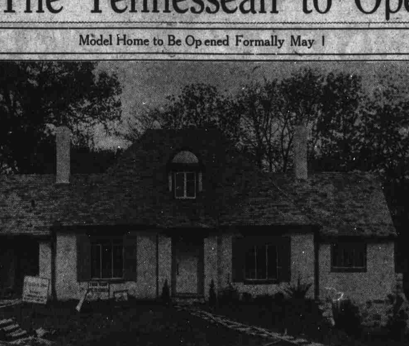 The Model Home as completed in 1927, 1612 North Observatory Drive — The Nashville Tennessean. The cream-painted brick, the hipped roof, the half-round dormer, and the paired chimneys all stand today. Public domain.
The living room holds what the Tennessean photographed in 1927
The room behind the front door keeps the two features the May 1927 interior photographs fixed: an exposed beamed ceiling, dark timbers crossing cream plaster, and an inset shelving niche set into the wall by the hearth. The fireplace is tiled and flanked by chairs; the front door, seen from inside, is the vertical-board leaf with a small leaded vision-light. Wide openings carry the eye into a dining room under crown molding and, beyond a turned baluster, up a stair. The carpet is a later teal and the furniture is the 2014 owner’s, but the shell — beams, niche, hearth, leaded glass — is the shell through which the newspaper toured fifteen thousand visitors on the first of May, 1927, and the match is exact enough that the identification needs no other interior proof.
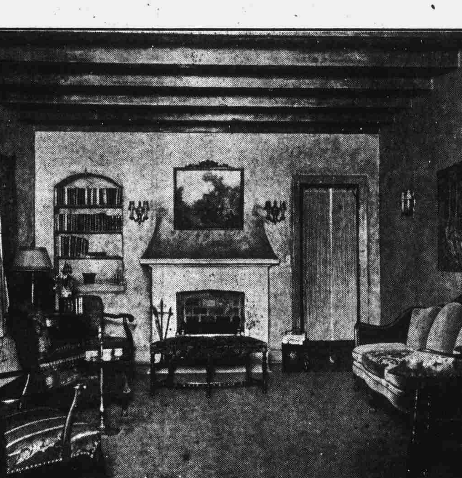 The Model Home’s living room, 1927 — the beamed ceiling, the arched inset niche at left, and the board door at right, the same features the 2014 photographs show — The Nashville Tennessean. Public domain.
The house falls with the hill, and the rear sets a garage in the foundation
The lot drops to the north, and the drop is the structural fact behind everything below the main floor. The rear elevation, shot from the garden, shows the house standing two full stories over a basement that meets the ground at grade: a two-car garage is set directly into the foundation, the brick of the front giving way to wood siding on the upper rear wall, and the conservatory pavilion — hipped roof, glazed walls, a small monitor at its peak — extends to one side over the falling ground. A garden path climbs to it through crape myrtles. Inside, the same grade registers in a short flight of steps between the dining room and the living room. The 1938 Sanborn map recorded this fall and this basement garage; the photographs confirm that the house still rides its hillside exactly so, which is what allows a basement to hold habitable rooms with windows at the back.
The Tennessean’s own description of the house still answers to the photographs
When the paper announced the sale on May 16, 1927, it set down what Bean had bought: “an 8-room cream-painted brick structure with servants quarter and two inbuilt garages in the basement,” a house that “sits regally, yet snugly, on its picture-like knoll.” Eighty-seven years on, the photographs answer the sentence clause by clause. The brick is still painted cream. The two inbuilt garages are the two-car bay set into the basement at the rear, where the slope brings the foundation to grade. The servant’s quarter the paper named is the sunken level whose low ceiling and high foundation windows the photographs still show. The knoll is the rise the front walk climbs under its canopy of trees.
The construction record fits the same way. The Tennessean photographed the house through January and February 1927 as bare wood studwork, its frame “completed” and its roof silhouette taking shape before, in the paper’s word, the “enclosing” began — the brick going on last, as veneer. The house still carries the order of that work: brick on the front it turns to the street, plain wood siding on the upper rear wall the display elevations never faced. The February caption promised that “the wide sweep of the roof is designed to give a definite feeling of shelter” and that “the large openings for doors and windows” would make “sunny rooms”; the hipped roof still sweeps low over the walls, and the leaded casements still bank the rooms in glass.
The lower level keeps the servant’s room’s dimensions and its light
Three photographs reach the basement. The first is a finished rec room: green walls, built-in shelving, a low flat ceiling studded with recessed lights and carrying ductwork close overhead, louvered bifold doors closing off the mechanical space. A second is the laundry and utility room: a suspended acoustic-tile ceiling hung on its grid below the joists, a long fluorescent fixture, a run of cabinets and a utility sink, a washer, a dryer, and a chest freezer, and — here too — small windows set high in the wall, one tucked just beneath the ceiling in the corner. The third is a basement bedroom. Its windows are short and wide — landscape panes a foot or so tall — and they are set high in the wall, their heads almost at the ceiling and their sills above the height of the headboard beneath them, near the eye of a person standing in the room; through one, the grade and its greenery sit at the glass. Measured by proportion against the door, the headboard, and the lamp, the ceiling reads at roughly seven feet, a foot and more below the beamed main floor. These are the conditions the 1927 specifications wrote into this level as a “servant’s room and shower,” and the conditions the 1930 census made flesh when it entered Sally Carpenter, twenty-eight, servant, on the line beneath Holt and Salome Bean. The paint is lavender and the carpet is new; the low ceiling and the high foundation windows are the room.
The later layers are a sunroom, a remodeled kitchen, and finished floors above
The remaining photographs record what the century added, named here so they are not mistaken for original fabric. Off the rear the owners raised a sunroom with a cathedral ceiling of tongue-and-groove plank on exposed king-post trusses, its walls glazed in tall lights over a low knee-wall; a second, earlier porch sits under a painted beadboard ceiling with bamboo shades and French doors to the yard. The kitchen is a late-twentieth-century remodel — cream raised-panel cabinets, tile counters and floor, a peninsula with stools, recessed cans under a soffit. Upstairs the rooms run beneath the roof: a study with its ceiling canted to the eaves and its windows backed by folding louvered shutters, a bath tucked under a skylit slope with vintage hex-tile, a primary bedroom under a tray ceiling with a window set in a deep wall reveal, a book-lined study opening to a bath, and a carpeted bedroom with a ceiling fan. The finishes are the 2014 owner’s; the deep reveals, the roof-slope rooms, and the steps between levels are the 1927 house carrying its later coats.
The photographs date to 2014 and show surfaces — carpet, paint, cabinetry, the cathedral sunroom, the finished basement — laid down decades after 1927; no interior finish here can be taken for original. The basement bedroom is not offered as the room Sally Carpenter occupied, only as the level, the ceiling, and the foundation windows her room shared. Every dimension given is a proportional estimate, the roughly seven-foot lower ceiling and the eye-level sills measured against standard doors, counters, and headboards, open to correction by a field measurement. The listing’s own figures — four bedrooms, three baths, three thousand five hundred square feet — describe the house after a century of additions and are no guide to the 1927 plan. The identification of 1612 as the model home rests on the deed, census, and architectural record set out in Identifying the Model Home and Holt Bean: A Life; these photographs corroborate that record.
Suggested Citation
Pemberton, Alex. “The Model Home’s Interior: A Century of Photographic Evidence.” Research Brief E11, Veneers of History in Green Hills East. alexaustinpemberton.com/journalism/veneers-of-history/#model-home-interior-photographs. Accessed [date].
Interview: Councilmember Jeff Preptit on the Green Hills East Overlay
Abstract
Councilmember Jeff Preptit, legislative sponsor of the proposed Green Hills East historic zoning overlay, sat for a recorded telephone interview on June 1, 2026. He described withdrawing the overlay legislation after making a tabulation error in a community poll and outlined the paper-ballot process he has since launched, with steering-committee oversight. Asked directly whether he was aware that deeds in the Plan of Green Hills carried racially restrictive covenants, Preptit said he was not and had not reviewed the deeds of any property. He expressed the view that white neighborhoods across Nashville receive greater historic preservation than Black and brown areas — calling that “simply a fact” — and argued for an honest reckoning with the city’s segregated history. The transcript is from automated speech recognition, edited for filler words only.
Interview
PEMBERTON: Little message. So, if we could start — I think I outlined a little bit about what the article’s about. It’s about the Green Hills East overlay, which I know has been a hot topic for you. What’s the status? Last I heard — last I know — you were taking it back to the community, going through the process again, and doing a new sort of voting process that I think was supposed to finish up maybe right about now. What’s the status?
PREPTIT: Yeah. So I think it would be helpful to sort of do just like a broad overview of sort of each thing that sort of happened up until this point and sort of how we got to that, which I think will be very helpful and informative for sort of the current status of things, if that’s alright with you.
PEMBERTON: Yeah. That’s that’s fine.
PREPTIT: Okay. Perfect. So yeah. So we’re obviously talking about the Green Hills East proposed historic zoning overlay, which includes a portion of a neighborhood that’s just to the west of Lipscomb University. And so the idea for this overlay was brought to me from a group of neighbors who had been concerned with some of the trends of development that they’ve seen in Nashville and across Davidson County, and also wanting to make sure that they are preserving some of the housing stock that they have in the neighborhood. And so I told that group of folks, like, I think this is appropriate for our area. But for me, the most important thing is making sure that there is community support for these kinds of proposed zoning changes. Because one of the things — and one of the conversations that I’ve always had with folks — is about how whenever we’re talking about things that are happening here in Nashville, we wanna make sure that things are happening for the folks of Nashville and not to the people of Nashville. So I told them point blank period that my position is I just wanna make sure that there is community support for this. And so if you all have the requisite amount of community support, then it’s something that I’d be willing to help with and move forward legislatively. And if there wasn’t community support for it, then that is the wishes and the wills of the community.
And so based off of that, we had — so I held a number of smaller intimate meetings with — I would describe them as, like, small groups of neighbors, usually 10 or 12 at a time — who wanted to discuss it with me, both folks who were in favor of the overlay and folks who were in opposition of the overlay. We also had a number of community meetings where folks from historic came and presented information on the zoning overlay. And so in the original process, the way that I went about trying to see what that level of community support was was, one, again, sending everything out, sending everything about the meetings out via my newsletter, making sure that they were publicly announced meetings that everybody was invited to. And as part of that process, I had been sending out — I sent out a survey via SurveyMonkey to folks on my mailing list. And I particularly asked folks — so let me let me back up and say this as well. So at the community meetings, I had sign-up sheets so that folks who were present could write down their name and their contact information so that they could be on the mailing list and put all of the information of folks who attended, who signed up. And whenever I sent out that original poll, I had asked folks, like, if there are people that you know who are interested in this, who want to register their vote, either email the survey to them or email me, and we’ll get it out to folks. And so if I’m recalling correctly, I’d sent either two or three rounds of emails for making sure that folks had access to it and held it open. If I’m not mistaken, held that survey open for about two and a half months to just give people ample opportunity.
And so once I got the results of that survey back, I had went through, calculated what the results were. And in that initial tabulation of the votes, I made a mistake. That was — and, again, I’ve said this to the community — that it was 100% my mistake and not on the part of anybody else in calculating those poll results. And so based off of that mistake that I made, I had reported some numbers both to the community and to the historic zoning commission, and those numbers were incorrect. And so because of that mistake that I had made, I took a step back, withdrew the legislation, and now where we’re at is we are — I have appointed a what I’ve been calling a steering committee to help guide a community engagement process. So part of that community engagement process is gonna be providing materials on both the historic zoning overlay and the alternatives of a contextual design overlay, providing them a comparator document that states what each one does, providing them all that information. It will also include a paper ballot that will be pre postmarked and be able to pre postmarked to be sent into the council office so that we’ve got every single person who submits a ballot into the council office and providing the steering committee the ability to audit that just to make sure that all the information, all the ballot tabulation is correct.
And so going back in the previous poll, the SurveyMonkey poll — so what the correct information shows on that poll is that there were 58 — and this is just the raw numbers, and then I’m gonna filter it down for you. So the raw numbers are that 58 people responded. Of those responses, 34 people voted yes, 13 people voted no, three people were undecided, and eight people had incorrectly filled out the ballots. And so that’s sort of just the raw number. So if you filter down for all of the folks who had input incorrect ballots and everything, the more accurate filtered down numbers are that 26 people voted yes — and these were the qualifying votes. So filtering down, these are the most accurate from the SurveyMonkey poll. So of those, 26 people responded yes, 12 people responded no, three people were undecided, and there were 17 votes total that were not qualifying votes either because they did not enter in their address or because they were duplicate votes. And so based off of that, the percentage wise from the poll is 63% of respondents voted in favor, voting yes; 29% voted no; and 7% were undecided.
And so based again, based off of the mistake that I made, I am going back through making sure that we have a robust community process where everybody has input, everybody has say, everybody has a free and fair opportunity to participate, has access to the information, and making sure that there are those safeguards in place to make sure, like, that the tabulation is accurate, that there’s oversight of it, and that people can have confidence in this community process.
PEMBERTON: So that’s kind of — appreciate that background. Yeah. Yeah. Yeah. Thanks. So what’s the status now? Where are you in that process, and what’s the timeline?
PREPTIT: Yes. So we — so I’ve been in discussions with both the planning department and with historic zoning, making sure that we have the most accurate information. I just got some of the doc — I just got one of the documents back that I’ll be sharing with the steering committee. So here in a little bit, I’ll be sharing out all of the documents with the steering committee for them to review, provide input on. And then once we finalize all those documents, they’ll be going to the printer, and then we will be engaging in that sort of canvassing process where the steering committee will appoint canvassers to hand out that material information with the goal of having people submit their ballots by the second week of July so that those can be — so that there’s plenty of opportunity to do that canvassing so people can get that ballot so that it can be tabulated and so that we can know with certainty what the community wants.
PEMBERTON: Appreciate that. Yeah. I appreciate the background on the political process, and I know that you’re careful about, you know, having a good clean record there. I think what I’m interested in and what the piece is really about is the historical record. You mentioned the conservation overlay versus the contextual overlay. What do you understand about — and you’re a lawyer, so you know, I know that this isn’t your specialty area, but you understand a little bit about the legal basis for each of those. Right? What do you understand in terms of the legal basis for the history aspect of that conservation overlay?
PREPTIT: Yeah. So and let me just let me make sure that I’m fully understanding the question. So is it more about, like, sort of the qualifying nature of — right. Historic preservation?
PEMBERTON: Right. Because they’re similar mechanisms, it sounds like, to do what the neighborhood wants to do, which is, you know, kinda control development. In terms of that, they operate similarly, but one has this historic merit aspect to it and the other doesn’t. Right?
PREPTIT: Yes. Exactly. So, with this particular neighborhood, so whenever it was subdivided and began developing, it was the original neighborhood within Green Hills. So it was sort of the course of development that started the Green Hills neighborhood. So that’s sort of just like the foundational basis. But looking at the particular eras of development and looking at whether or not there is a cohesive story of that process of development. And so looking at the fact that this area was the original Green Hills neighborhood is sort of the basis upon which the neighborhood has looked into whether or not historic preservation would be appropriate in preserving that story of the original Green Hills subdivision or neighborhood. So that’s sort of the historic basis for a historic zoning overlay, if that makes sense, if I explained it well enough.
PEMBERTON: Uh-huh. Yeah. That makes sense. So another piece of it, as I understand it, was really centered on this model home. It was, I think, the first home constructed in the neighborhood. And this is a central piece of my reporting. We found that the home that was identified by MHZC staff was not the correct home. Are you aware of that?
PREPTIT: So I’ve been told a couple of different things. I’m not fully aware of the home being misidentified. I haven’t heard that in particular, but I can recall — and apologies if I’m misremembering this — but I can recall folks stating to me something along the lines of — what was it? Sorry. I’m — because I can recall somebody stating to me essentially along the lines of that — I think the issue that I’m remembering is that there was a home that was included in a presentation about sort of just the historic development of it. And the issue that was raised to me was that that particular homeowner wasn’t aware that their home was gonna be included in that packet. That’s what I’m recalling off the top of my head. To the best of my recollection, I don’t recall any conversation particularly about that home being misidentified, but that’s what I’m remembering right now.
PEMBERTON: Uh-huh. Got it. Yeah. So we did conclude — and this has gone through the Scene’s fact checking and everything. We’ve got it triangulated by more documents than you can name — that the home was misidentified. I know that there was a question at the time about whether it was contributing, given that it didn’t look anything like the home, but it was actually the wrong home. And one of the ways that we determined this was that the reported buyer — we linked to the original deed that placed it at 1612 North Observatory. Are you aware that the deed for that house, and for all of the houses in the subdivision and neighborhood — the Plan of Green Hills — contained racial covenants?
PREPTIT: Contained what? Sorry. Could you repeat that?
PEMBERTON: Racially restrictive covenants.
PREPTIT: So I am not aware of that. I have not reviewed the deeds of any property in particular. Really, my focus has been and continues to be on making sure that this is something that the community actually wants, which is part of the reason why we’re going through to make sure that as many people who want to participate can participate and that they have as much information as possible and that they have as much opportunity to register their opinion and make sure that this is something that they actually want for their neighborhood.
PEMBERTON: Do you think that having the accurate history would influence that perhaps?
PREPTIT: Yeah. So I wanna make sure that we have the most accurate up-to-date information as possible, which is part of the reason why I have been going through this process of making sure that all the material is objective and reasonable, making sure that again, going through and making sure that both planning and historic have provided input to make sure that the documents are accurate, making sure that all of that information is, again, as up to date and accurate as we possibly can. So I wanna make sure that folks have as much information as possible.
PEMBERTON: So what’s the working relationship with the historic commission been like? I mean, you know, you’ve obviously — you’re running the community engagement process, you’re rounding up the neighbors, and you’re doing all of that. But I wanna understand a little bit more about how the production of the historical narrative and the dissemination of that sort of fits in or factors into your side of the process.
PREPTIT: Yeah. So I will say I’ve had a really good working relationship sort of across the board, stepping apart from this particular legislative issue. But I’ve had a good working relationship across the board with both folks in planning and historic. Because throughout this process, I’ve been having conversations with both folks. Because, again, looking at wanting to make sure that folks have as much information and have a comparator document that compares a contextual design overlay to a historic zoning overlay. I’ve had a really good relationship with folks and have been able and feel as if we’ve worked really well with making sure that we are getting all of that information out. I will note that there are folks who have raised concerns about whether or not there have been folks within historic zoning who have had a conflict of interest. And so, like — so I know one of the folks that we worked with early on is Robin Zeigler. And knowing that, again, she’s relatively high ranking within the Metro Historic Zoning Commission — or within their historic zoning staff, because with the way that it’s been reorganized with being under planning — we’ll get into the minutiae there. But all that is to say is so folks have raised those concerns. And so part of what I have done is making sure that I’m working with a broad base of people who have that experience and who can help make sure that the neighborhood is as informed as possible. So I’ve been working with a good amount of folks who have helped to advise and guide us in this process. And so I feel as if I’ve got a really good working relationship with folks and able to ask those questions and get as much information as we possibly can.
PEMBERTON: Do you recall off the top of your head any of the other MHZC staff members or commissioners or whomever else that’s been instrumental?
PREPTIT: Yeah. So my two primary points of contact have been Brett Withers with the planning department and Melissa Baldock with historic zoning.
PEMBERTON: Uh-huh. Got it. Got it. Excellent. Thank you. So, yeah, I’m looking again more at the more on the historical side and more on the structural side. And one thing that we found in addition to some of the errors and omissions within the Green Hills history is that there’s really quite a large distinction between how some of these foundational issues of the neighborhood — or all of the neighborhoods, really, under overlays — are discussed and how those histories are narrated. To say it way too shortly, white histories are narrated as architectural achievements, you know, sort of like Green Hills — its contributions to nomenclature and things of that nature. Black neighborhoods are narrated essentially only for their, you know, role or response to segregation and racialized histories. Right? What we found is that 19 of the 27 overlays contain racial covenants. Those were foundational to the neighborhood. Right? That is part of white history, even if it’s not talked about. Right? It wasn’t talked about in Green Hills. It’s not talked about in any of the other overlays. So I think what I’m wondering is, you know, there’s a conflict of interest maybe with Robin — I think that’s a little bit conspiracy-theory stuff. I’ve always known Robin to be honest. But I think there’s potentially a larger conflict of interest in that the narratives are written to support the overlay adoption. Right? Like, the neighborhood comes to the MHZC and they say, we want an overlay. The MHZC says, okay, let’s help you do it. Do you see that, or am I off base with that characterization?
PREPTIT: So the way that I view this process and the way that I view the role of the historic zoning commission rather is that their role in particular is to determine whether or not an application for installing or creating a historic zoning overlay is looking at the particular code section and the legal guidance as to whether or not they fit in minimally. So just the way that I view their role is sort of just making that minimum determination as to whether or not they qualify, not necessarily a policy recommendation on whether or not it’s a good idea or a bad idea. So that’s one part of it — what I view their role is. Now I will say more broadly when it comes to historic preservation across Nashville, I think the way that you’ve categorized it is not inaccurate. What we have seen and what the data shows and what you pointed out is that oftentimes — and putting it frankly — is that white neighborhoods are granted greater historic preservation than Black and brown areas of the city have. That’s simply a fact. That doesn’t necessarily mean that we should not be doing more, that we should not be doing historic preservation. I think part of what we need to do is do a reckoning with that and tell an honest story of the history of Nashville and the history of development in Nashville, which includes the fact that Nashville, for a large portion of its history, was a segregated city. And to a certain extent, Nashville does have — had certain pockets of populations that people could argue that the city, to a certain extent, is still, to a certain extent, segregated because you’ve got different hubs in different areas of population. And, like, I will say, I fully recognize, like, even though I am a young Black immigrant civil rights attorney, I also recognize that I represent one of, if not the, widest districts in Nashville. And so I think it’s really crucial for us to be honest about what our history is and tell that story and provide equality of opportunity for preservation across the board. So that’s that’s my view on historic preservation and the importance of it because it does need to be applied across the board and not only tell the story of white areas, but also preserve the history of Black areas in Nashville. And not just the story of the systemic oppression and racism that these neighborhoods have had to overcome, but also how they have triumphed and how they have built out of really, out of nothing in areas that other folks in Nashville didn’t find desirable. So, yeah, that’s my position is that I think that we need to do a better job of the historic preservation across the board.
PEMBERTON: I appreciate that. So, we’ve got just a few minutes left. So why don’t we talk now about, you know, knowing this? And again, I know that I gave you the very high-level summary version of this, and that’s almost unfair. And I’m happy to send a little bit more documentation of some of these findings so that you know them before the story runs. But, knowing what I’ve told you and sort of the direction that this is going, how do you think that that changes how you approach the overlay process going forward?
PREPTIT: Yeah. So I think the really important portion of this, I think, is making sure that we have an accurate reckoning and telling an accurate story of not only just the development in Nashville, but what that development meant for Nashville. I still think it is crucially important to listen to the voices within the community. If particularly, if this is something that they want to continue moving forward with — with telling that particular story of preservation and telling the whole story — I think that that is, again, a decision for the community to make. Because throughout this entire process and what I continue to endeavor to do is reflect the voices of those who live in the neighborhood and those that are gonna be the most affected by it. And so really just making sure that this is something that the community wants and making sure that we are having an accurate telling of what that story is.
PEMBERTON: Okay. Well, I’ve been driving this. I’ll leave the last couple minutes to you. If there’s anything that you thought of along the way, anything else that you wanna say — what should people know about this, about this process, about you, about what you’re doing here?
PREPTIT: Yeah. So I’d say, really, the — and I’ll just reiterate what I’ve been saying. The most important thing for me is making sure that, again, that it is accurate, that people are getting the best information possible, but enabling and empowering the folks in the community to be able to, one, tell their story, but, two, decide what happens with their neighborhood. Because, again, like I stated, for most of the folks in Nashville, we wanna make sure that what is happening here is happening for us and not just to us. And so my goal, again, is just making sure that this is something that the community wants and making sure that it is that they are getting the best possible information to make an informed decision on whether or not they wanna move forward with the historic zoning overlay.
PEMBERTON: Excellent. Well, thank you again. You’ve been wonderfully candid, and appreciate you carving out the time to have this conversation. Like I said, I’m happy to, you know, provide any additional information via email or what have you so that you know — my deadline for the story is Wednesday morning, the third. And then it will run in the June 11 issue. So that’s what the timeline looks like. Like I said, if I could be of help in any way, I’m happy to.
PREPTIT: Yeah. Absolutely.
[The call concluded with an exchange Councilmember Preptit asked to keep on background; it is omitted here.]
Sources
A recorded telephone interview conducted by Alex Pemberton on June 1, 2026; transcribed with Deepgram Nova-3 (automatic speech recognition with speaker diarization) and edited for filler words only.
Suggested Citation
Pemberton, Alex. “Interview: Councilmember Jeff Preptit on the Green Hills East Overlay.” Research Brief E12, Veneers of History in Green Hills East. alexaustinpemberton.com/journalism/veneers-of-history/#preptit-interview. Accessed [date].
Interview: MHZC and Metro Planning Staff on the Green Hills East Short History
Abstract
On June 1, 2026, beginning at approximately 3:30 p.m., three Metro government staff sat for a recorded telephone interview with Alex Pemberton: Robin Zeigler, Senior Preservation Planner at the Metro Historic Zoning Commission (MHZC), who authored the Green Hills East Short History; Joni Williams of Metro Planning’s design studio, who addressed process and the forthcoming preservation plan; and Richel Albright of Metro Planning, who addressed department history and the overlay’s procedural status.
The interview covers four areas. First, how Short Histories are made: Zeigler explained there is no standard template, the research drives their content, and different ones have been written by different staff or consultants; Albright added that the MHZC is at its core an architectural review board, so the research focuses predominantly on structures. Second, the model-home identification: Zeigler said she identified 1637 South Observatory Drive through newspaper articles, “by address and maybe by photos,” and deed and directory research, but could not recall specifics and offered to pull her notes; Pemberton noted that no Tennessean article gives an address, and that 1637 was bought in January 1927 by Mizella Burton Grant — A. M. Burton’s daughter — not by Holt Bean, the buyer the paper named. Third, the covenants: on the minimum-cost covenant, Zeigler said “In [the] deed”; on racial restrictions, she said that on “the deeds that I looked at, I didn’t see it,” though “I was actually kind of looking for it,” and that she had “looked up one yesterday and didn’t see it.” Pemberton read the racial covenant aloud, and Zeigler confirmed she had not seen it. Fourth, staff framed Green Hills East as architecturally focused, confirmed the overlay’s withdrawal and that a refiling would be a new application, and described a coming Metro preservation plan as a chance to revisit research standards.
The transcript below is produced from Deepgram Nova-3 automatic speech recognition with speaker diarization (four speaker channels). It has been edited for filler words only (um, uh, you know, filler like, stutter-repeats), with consecutive same-speaker fragments merged into single turns. All other words, word order, false starts carrying content, and colloquial grammar are preserved verbatim. Speaker attribution between Williams and Albright rests on Joni Williams’s self-identification at the outset of the call; all other attribution is as diarized. Turns where attribution is uncertain are marked [speaker?]. Uncertain words or names are marked [?].
Interview
Speaker-number mapping used: SPEAKER 0 = PEMBERTON; SPEAKER 1 = ZEIGLER; SPEAKER 2 = WILLIAMS; SPEAKER 3 = ALBRIGHT.
PEMBERTON: Okay. So thanks again for joining. We’ve got a lot to cover in an hour here. I think, you know, again, sent a topic list, so hopefully you feel prepared. If we can start — why don’t we just start by, Robin, if you could walk me through what is a Short History? How does it get made? Who researches it? Who writes it?
ZEIGLER: The research is done by lots of different people, and the writing too — staff of the Metro Historical Commission, staff of Historic Zoning Commission, or maybe even a consultant. So over the years they’ve been written by different people and researched by different people. The purpose of them is to help the commission decide whether or not it meets the standards that the ordinance lays out for them for creating a historic overlay.
PEMBERTON: And what is the standard? What does that mean?
ZEIGLER: The ordinance lays out the standards that a property would need to meet in order to qualify for an historic overlay. So that’s Section 17.36.120. And there are five standards that are really pretty aligned with the National Register process as well.
PEMBERTON: And so the Short History is sort of what makes them understand whether this is historically significant or not?
ZEIGLER: Yeah. It’s a tool that they use.
PEMBERTON: And so who specifically wrote the Green Hills East one? Do you know which staffers?
ZEIGLER: Yeah, that was me.
PEMBERTON: That was you? Okay. Great. So I’ve got a few copies here in front of me. Obviously you have a finished one. There’s one — I believe it was called “A Short History of Historic Green Hills East” — that looks like a less finished version. I think there’s a January date attached to it. I’ll kind of work off of that and ask a few questions from there because it has several more pieces of documentation; it’s got some footnotes with sources and things like that. I know you’ve made some changes in what seems like a finished version over time. It seems like this is maybe a fuller version of the research that you did.
WILLIAMS: Alex? So — this is Joni. Just one quick second. I think you’re not seeing a less polished version and a more polished version. What you’re seeing is one that had to sort of conform to the formatting that the MHZC team typically uses, and the actual full document. So you’re not seeing an evolution in time. You’re seeing one that’s formatted and one that is more of the actual product and the working document, if that makes sense.
PEMBERTON: Got it. Absolutely, that does make sense. Thank you for that. And so — is there a written standard, written template? Is there, like — are those sections, like, “we need to cover this, this, and that”? Is that just purely formatting? I’ve read a few of these by now and some of them seem different, but that may just be over time.
ZEIGLER: I don’t know what you mean by a written template with different sections. Can you —
ALBRIGHT: Are you talking about the staff report?
PEMBERTON: I’m talking about the Short History. So I see we’ve got one that has the map of the district, the proposed district, and then it starts with “A Short History of Green Hills East.” It goes into development, it goes into the home construction, it goes through these different sections. Is it like — is there a sort of standard template that says we need to talk about how the land was subdivided, what it was before, or is this sort of case by case basis?
ZEIGLER: I think you’re talking about the staff report. So the first few pages — the first six pages — you’re right, there’s a template to the report, and then after that is the Short History. So are you asking about the short —
PEMBERTON: I’m asking about the Short History. Yeah. I’m asking about the short history. This one, I think — and correct me if I’m wrong — starts “A Short History of Green Hills East NCZO”. It has a picture of the “Opportunity Green Hills” advertisement, a little clip of Green Hills prior to home construction, and a couple sections — Development, Home Construction — that Short History.
ZEIGLER: Again, I’m so sorry, I don’t fully understand the question. There’s no template to the Short Histories. The — it’s the research that drives what they say.
ALBRIGHT: One thing too, Alex, to just kind of remember is the Historic Zoning Commission at its core is an architectural review board. And so I think the research that is predominantly focused in these Short Histories is on the site, structures, buildings, and the like, if that is helpful.
PEMBERTON: Yeah. Absolutely. And we will get to that. But this document is pretty important to the determination of whether the MHZC should recommend a historic overlay or not. Right? Because otherwise you would just say that this area has beautiful architecture or whatever.
WILLIAMS: Alex, I want to go back to the section that Robin was referencing in the code — Section 17.36.120. There are five very explicit pieces of criteria that the commission is tasked with considering. And so this is just one of the pieces of evidence — the short history is just one piece of evidence or content that the commission reviews when they’re considering whether or not an area rises to the level of those criteria. So we’re happy to send that to you if that’s not already on your radar, that section of the zoning code.
PEMBERTON: Yeah. I’ve got that. Thanks. I think it was one and three that they found a recommendation for on this one. So — why don’t we talk about that, the case for significance? Robin, if you could. As I understand it, there are a couple pieces. I can just read off: “The district is the namesake for the larger Green Hills area and a significant representation of the national initiative to promote homeownership and educate about modern materials and construction practices beginning in the late nineteen twenties.” And as I understand it, that “national initiative” was the Better Homes in America movement, and that is via its association with the Tennessean Model Home. Is that correct?
ZEIGLER: That’s right.
PEMBERTON: So — what sources did you rely on to identify the Tennessean Model Home? Because as I understand it, there weren’t addresses for this area back at that time.
ZEIGLER: There weren’t specific buildings. We can send you a copy of the history — it’s all footnoted.
PEMBERTON: I’ve got that in front of me.
ZEIGLER: So I’ve used newspaper articles. There was a book called The Book of a Thousand Homes that’s on the preservation technology website. And mostly newspaper articles. So it wasn’t about picking out specific houses, although there is one that was repeated as a model home in the Tennessean over and over and over again. But it was also about looking at the architectural form and style and seeing those kinds of houses in plan books of that era from that organization.
PEMBERTON: But that was one of many plan books, right, that went back?
ZEIGLER: Yes.
PEMBERTON: I mean — like, Lockeland Springs has a number of these houses that were built off plan books preceding this. Right? So that — it’s that specific connection to that Home Owners’ Service Institute, that specific connection to the Better Homes in America campaign with the Tennessean Model Home that sort of made this one significant in a way that other neighborhoods built with plans from plan books are not necessarily, for that reason. Right?
ZEIGLER: Again, that’s sort of a broad statement. And I think you mentioned Lockeland Springs — that’s a much earlier development. I don’t know if there’s much of a comparison there.
PEMBERTON: Okay. Well, that’s fine. Moving on. So most of the Short History — a large part of the short history, I don’t want to say most — but it talks about the Tennessean Model Home located at 1637 South Observatory Drive. How did you identify that home at that address as the Tennessean Model Home?
ZEIGLER: Through the newspaper articles.
PEMBERTON: Through the newspaper articles. And did they have an address? How exactly?
ZEIGLER: I believe it was by address and maybe by photos. I can’t remember exactly. This was done a couple of years ago.
PEMBERTON: I tried to do the same. They were not addressed. I never found an address for the Tennessean Model Home. So if you have, I’d like to see it, just to make sure that I’ve got the record right. But so you saw photos — you presumably saw the construction photos. Right? You saw all the descriptions of the model home being built and this and that from the Tennessean. Correct?
ZEIGLER: I don’t recall photos of it during construction.
PEMBERTON: Okay. But you did see — stories where it says, you know, “brick veneer” and “the Tennessean Model Home nearing completion,” things of that nature?
ZEIGLER: That’s correct.
PEMBERTON: Okay. So we’ve got a brick veneer house on a wood frame. Right?
ZEIGLER: Mhmm.
PEMBERTON: I see in the footnoted version you’ve also consulted a Sanborn map, which I see noted as the 1951 Sanborn map, but it looks like the 1957 because a lot of the houses are not filled in, color coded. Regardless, it looks like the house that you’ve identified is, in both the 1951 and 1957, entirely filled with pink shading. Do you know what that means for a Sanborn map?
ZEIGLER: I believe that was that it’s a brick veneer.
PEMBERTON: That means it’s entirely brick, structural. So a brick veneer would be a yellow shading with a pink border. So — this leads me to a little bit more: Given the significant modifications over the years, how did you connect 1637 — which is this large sort of sprawling Tudor, which is noted as being entirely structural brick on Sanborn plans and other things — how did you connect that to this pretty diminutive, symmetrical English cottage style building that’s shown in these Tennessean photos as being this new model home?
ZEIGLER: I’ll have to get back to you on that. This was researched a couple of years ago. But I can pull up my old notes and give that to you.
PEMBERTON: And did you triangulate the identification of the home in any way other than looking at photos and Tennessean clippings? I see that there’s one — it looks like a map that sort of maps onto, or eyeballs onto, 1637. Did you go through deed records or anything to sort of verify that — that this goes back and Holt Bean, who they said was the buyer in the Tennessean, owned this property? Did you do any of that?
ZEIGLER: I did.
PEMBERTON: Okay. And so you found Holt Bean owned Lots 12 and 13?
ZEIGLER: That’s just a level of detail I don’t remember. But I looked at deeds, directories, newspaper articles, maps, photographs.
PEMBERTON: Okay. Because I did the same. I was not able to find Holt Bean ever having owned 1637 South Observatory. It was actually purchased by Mizella Burton Grant — who I’m sure you probably are aware was A. M. Burton’s daughter — in January 1927, while the Tennessean Model Home was under construction. I looked as well, because it’s pointed out on the short history, at 1612 North Observatory. Did you trace the deed records there?
ZEIGLER: I’ll have to get back to you. I don’t remember. We definitely looked at deed records, certainly not for every single house. So I’ll have to get back —
PEMBERTON: But this one — 1612 North Observatory — it’s noted here that the same floor plan is evident in 1612 North Observatory. Would that have required a different level of investigation than any other house in the neighborhood?
ALBRIGHT: Where — Sorry, can you say what page you’re on and what section, Alex?
PEMBERTON: Yeah. So on the footnoted version — let’s see. Where was I?
ALBRIGHT: Is that page seven?
PEMBERTON: Yeah. So there are several photos on page seven. I’m looking for where it specifically says that the floor plan is evident. But regardless — 1612 North Observatory was on your radar. Right? And you did some deed search and did not find — or did find — Holt Bean as having owned 1637, but not 1612. Is that am I understanding that correctly?
ZEIGLER: I don’t —
WILLIAMS: Hey, Alex. Can I just kind of cut to the chase here maybe? Are you just disagreeing as to which house was the Tennessean’s house?
PEMBERTON: Yes. We have confirmed through deed records, census records, photographs, everything else, that the Tennessean Model Home was misidentified.
WILLIAMS: Okay. Thank you for bringing that to — Okay.
PEMBERTON: Yeah. Absolutely. And so the next thing that I want to ask about is — because we looked through the deed records and because we saw who owned this house, we saw that all of the deed records refer to a set of restrictive covenants. Those covenants, I think, are referred to in the short history as minimum construction cost — I think it’s $5,000 minimum construction cost that varied across lots. That would be on page seven, footnote 14. It looks like that’s cited to the Tennessean, not to the deed record. Is that correct?
ALBRIGHT: I have — wait. I have footnote — you said footnote 14?
PEMBERTON: Footnote 14. Yeah.
ALBRIGHT: I have that on page six. I don’t know if that’s helpful, Robin. Page six.
PEMBERTON: I may be looking at a different numbering system here.
ZEIGLER: Footnote 14 isn’t referencing a deed.
ALBRIGHT: But footnote 15 on page seven is the only footnote. It says “New Subdivision Sells Rapidly,” Tennessean, 02/06/1927. Is that what you’re referring to?
PEMBERTON: That’s right. That’s the one.
ALBRIGHT: What was the question on that again? Sorry.
PEMBERTON: So it was the minimum construction cost as part of the deeds — which is where that’s located. It’s a covenant. Right? So that was determined through the Tennessean, not through the deed itself. Is that right?
ZEIGLER: That footnote should have been the sentence before it.
PEMBERTON: Okay. So where did you see the minimum building restriction?
ZEIGLER: In the deed.
PEMBERTON: Okay. So you also saw the racial restriction?
ZEIGLER: I didn’t.
PEMBERTON: Okay. It is — it’s the line immediately below the minimum building restriction.
ALBRIGHT: On the deed?
ZEIGLER: On the deeds that I looked at, I didn’t see it. It’s really common to have that, so I was actually kind of looking for it. But on the ones I looked at, we didn’t find it. So we don’t do in-depth research on every single house — neither does the National Register nomination.
PEMBERTON: But these covenants were recorded with every deed in the neighborhood. Are you aware of that?
ZEIGLER: And so you’ve researched every single house?
PEMBERTON: Yes.
ZEIGLER: Interesting. I just looked up one yesterday and didn’t see it.
PEMBERTON: Hmm, okay. Fascinating. Yeah. So — well, they are referenced, they are by reference. So I’ll read you — this is Book 919, page 110, and this is the deed from T. J. Haile Jr. — who you may know as the builder of the Tennessean Model Home — to Holt Bean. It references restrictions and conditions contained in the deed, record Book 700, page 653. And so that’s where those restrictions are contained, specifically for that house. Again, when they were sold to the initial purchaser, every house in the neighborhood contained these restrictions. So — I can, if you want, go ahead and read you what that one looks like. Do you want to do that?
ALBRIGHT: Yeah. Go ahead and read it.
PEMBERTON: Yeah. So this one has a $7,500. This is the third clause — the $7,500 restriction. And then the fourth clause, which begins immediately after the number $7,500 — the fourth says: “Neither said property nor any part thereof shall be aliened or conveyed to persons of African blood or descent, and no person of African blood or descent shall be permitted to own or occupy the premises except in the capacity of servants.” So you didn’t see that in any of the deeds — it shares a line with the price. That’s correct.
ZEIGLER: I didn’t see it. But we would love to see whatever research you’re willing to share with us, because the overlay has been withdrawn. And if it’s refiled at some point, there’s an opportunity to revise all this.
PEMBERTON: Yeah. So I think that would probably be a good idea, because the errors and omissions here are pretty significant. Obviously a lot of this is pretty pro forma. But I sort of want to talk about this racial restriction a little bit more and how this factors into short histories in general. Obviously these covenants, as you noted, Robin, are widespread — I think about 40% of the parcels in overlays trace back to a racial covenant. But none of the short histories acknowledge that. Is that because you simply didn’t find them, or is that an editorial decision, or is that just not important to what you do?
ZEIGLER: I mostly haven’t written them, so I have no idea. Quite a few were written before my time, written by other people. I’ve written, like, two.
PEMBERTON: Should they be rewritten if they don’t include something like that?
ZEIGLER: Oh, I think that we could always be rewriting them. There is always new information, always new ways of seeing old information. I think that would be great.
PEMBERTON: So we’ve found — and part of the story will be just simply that 19 of the 27 conservation overlays do have racial restrictions somewhere within them. And none of the short histories reference those, which is pretty important. Obviously, over the last couple of years, through the NPS Underrepresented Communities Grant and other efforts, you’ve started to focus more on expanding and diversifying into historically Black neighborhoods. Right? Can you tell me a little bit about that process and what you all have done there and the importance of that?
ZEIGLER: That’s the work of a different department — that’s the Metro Historical Commission. But I can speak to the fact that we have multiple predominantly African American communities. Lathan’s Court is one of my favorites. It’s one that I did write, that was started by the first African — or one of the first African American — police officers. He owned the land, he started the development, he continued to live there. That’s one I feel a lot of connection to… Marlin Meadows. I’m drawing a blank on the name of the other one.
PEMBERTON: Haynes Heights and Haynes Manor maybe?
ZEIGLER: Haynes Heights. Yeah. Those — that was fun to put together as well. Really great people there.
PEMBERTON: Those were really well done. They did, again, really focus on the African American history and that social history. And I look at Green Hills East and I see that missing. We’ve got a nice big list of important homeowners, things like that. How much does the social history matter to these — what are architectural histories?
ZEIGLER: It depends on the history of the neighborhood. So some of the overlays are based on their architectural designs. Some of them are based on how they developed — like Lathan’s Court. It’s split levels and ranches, so in terms of architecture, it’s nothing really special, but in terms of its history, it is. So it just depends on the history of the neighborhood and what makes it significant.
PEMBERTON: So — is it significant that a neighborhood was deliberately segregated? Is that a significant part of the social history?
ZEIGLER: I don’t know if it’s significant — if it alone would be the reason for it to be an overlay — but it’s certainly an important part of its history.
ALBRIGHT: And, Robin, to the point that you made a second ago, some of these reports are far more based on an architectural versus how the neighborhood was created, and that’s where it seems like more of that social component and cultural component comes in. Whereas with Green Hills East, this feels more so on the architectural component. I hear what you’re saying, Alex, in terms of these restrictions within the deeds, and that is an important thing. But it sounds like each overlay, as they are reviewed and researched, it may be different based on what is the story being told of a community. Is that fair to say, Robin?
ZEIGLER: That’s right.
PEMBERTON: I get that. And I think that — I mean, what sort of threw me to this one and looking a little bit more into it, as you know, I’ve written on similar subjects in Nashville’s history — what drew me to this one was just how closely the architecture and that social history are linked. This Better Homes in America model home — I don’t need to tell you, Robin — was very much designed around an ideal of how to live, how to socially live.
ZEIGLER: Right.
PEMBERTON: It’s encoded in the floor plan, right? And I thought that it was interesting in this one that there were servants’ quarters, because — as I understood it, I’ve read a couple books on Better Homes in America — for the most part they were not designed with servants’ quarters, and servants — Black domestic workers in that period — tended to live in other neighborhoods and come in if they were hired. So I thought it was interesting that there were servants’ quarters, through sort of triangulating the owner and tying the ownership back to 1612 North Observatory to identify that as the model home. I saw that they did actually have a live-in servant. Her name was Sally Carpenter. She would have obviously slept in the basement and worked in the home throughout the day. So I just want to sort of understand: Is there such a clear distinction between architecture and architectural history and social history? Can you make that distinction so clearly?
ZEIGLER: I didn’t look at floor plans, and I don’t know what the existing floor plans are. I haven’t been inside — well, I’ve been inside one house. So I’m not — we didn’t go into that level of detail.
ALBRIGHT: Because, typically, Robin, your commission is looking at the exterior, not the interior.
ZEIGLER: It’s a short history. It’s not an in-depth history of the entire neighborhood. It’s to provide information to the commission about the exteriors, about its history, so that they can determine whether or not it meets the qualifications and to give us some idea of physically what the exteriors look like, so we know what we’re protecting through the guidelines. It is not in any way an exhaustive history of the neighborhood.
PEMBERTON: It should be an accurate one, though. Right?
ZEIGLER: Yes.
PEMBERTON: Yeah, okay. So — I do see exterior photos again of the model home, and it looks like one plan book home. But otherwise this reads to me — and I’m not a trained historian — but it reads to me like it’s largely a social history. It is about the movement toward homeownership in the early 1920s. It’s about how that model home and the owner of the model home — his career arc — developed, and who lived in the neighborhood. That’s a social history. Right?
ZEIGLER: Who lived in the neighborhood was just included to give you an idea about the history of the neighborhood. It’s not significant because of who lived there.
PEMBERTON: And so what specifically made this neighborhood significant? We had criteria one and three. But could you describe that in a little bit more specific, layman’s terms, outside of just, here’s what the code section says?
ZEIGLER: It’s in the report as well, but it’s based on the fact that it was this national movement for home building.
PEMBERTON: And so the sourcing for the characterization of that national movement — the Better Homes — I see only one footnote related to that, and that looks like it was that Book of a Thousand Homes, that comes from the Home Owners’ Service Institute, which is the publishing arm of that movement. Right?
ZEIGLER: Correct.
PEMBERTON: Was that the only source consulted, or were there other sources that just didn’t get cited?
ZEIGLER: We look at lots of different things that don’t actually make it into the histories.
PEMBERTON: Do you have an idea of what else you looked at to sort of characterize the movement?
ZEIGLER: I’m sorry. I don’t. It’s been a couple of years.
PEMBERTON: Yeah. Well, again, I’m fairly familiar with this topic, have read a number of books, and I think that the connection again between that social history and especially that history of segregation and this movement were a bit more closely linked than what I read here. I don’t want to continue beating this. I think you guys understand what this is and where it’s going and what the story is going to be. Maybe how we can spend the rest of our time productively is talking about what an accurate history looks like — what a somewhat complete history looks like — and how the MHZC sees that going forward.
ALBRIGHT: Yeah. Before we jump into that, Alex — one, I’m grateful that you are bringing forward some things that, again, as Robin said, if this is brought back by the councilmember, we can make these edits and modifications. And one of the things that the Historic Zoning Commission staff have been with the Planning Department for a year now — just a little over a year. Or no, it’ll be a year in July. Time flies. And one of the things that I’m grateful for is they have helped us think about processes within our own purview, but also vice versa, helping them think about how they’re reviewing things and researching and the like. And we’ll be doing a preservation plan, starting with a scope later this year and then doing the work, hopefully in earnest, in the next calendar year. And some of these questions that you’re raising could be helpful questions as we’re building out a scope of how are we using guidelines, how are we using research, how are we using social histories versus just architectural structural histories when we’re working on these reports. And so I just wanted to, one, thank you for elevating some of this, and two, we are never so set in our ways that we can’t modify and change things and make sure that we’re doing the best and highest productive work as well.
PEMBERTON: Yeah. For sure. Can you tell me a little bit more about the preservation plan? You mentioned some opportunities to set standards, set guidelines, that template for how you do that. How could some of the things that I’ve raised be better handled through that process? How would MHZC and Planning approach that?
ALBRIGHT: Sure. I’ll take a quick stab, and then, Joni, if you want to jump in, because I know you’ll probably be drafting an initial scope. Some of it is, let’s make sure that as we are moving forward — we’ve got a template obviously for a staff report, but maybe there are templates and things that are put in place as we’re doing specific research. I think Robin is correct — these histories reveal themselves based on the research. Let’s make sure we’ve got things in place of utilizing different types of sourcing — just, being specific to what we’re discussing today, I think that’s an easy step to implement — and making sure that we understand the guidelines in writing these. Joni, I know you’ve probably given a little more thought to the preservation plan as a whole.
WILLIAMS: Sure. So I think, Alex, one important thing that we’ve been chewing on over the last year or so is how do we plan for preservation? That is not something that most people do proactively. Typically — most cities, and I think this is true across the board — preservation tends to be reactive. And I think Nashville has a really important opportunity to be more proactive on preservation. And so that might look like individual iconic buildings. It might also look like neighborhoods, for a variety of meaningful reasons. But it also may be to strategize about what the criteria are for a neighborhood being meaningful for preservation. And so — this is probably some of the inner workings, Alex, that don’t matter, but I want to share them with you anyways — we will have a neighborhood come to us and say, “We’re experiencing this, that, or the other, and we want to think about the zoning tools available to us.” And this happened even before Historic Zoning came to Planning. So you might look at a contextual overlay. You might look at the two-story overlay. You might look at a community design overlay that can be customized. You might look at a preservation overlay. And so the one that always comes to mind for me is the Primrose neighborhood, that’s just inside 440, where they felt very open to new construction, open to change, but they just wanted some design criteria in place. And so thinking about how we grow and preserve simultaneously is going to be a really important component of the preservation plan. Now what that means in the actual prioritization of what kind of history we’re preserving — whether that’s architectural significance, social significance — I think is up for rigorous debate as we move into that very, very extroverted, community-based conversation, in — as Richel mentioned — 2027.
PEMBERTON: Yeah. So what I’m hearing is that there’s an opening for a more proactive preservation approach where, rather than waiting for neighborhoods — which it sounds like has been the model — waiting for neighborhoods to come and say, “Hey, we want this,” maybe it’s MHZC staff proactively identifying neighborhoods and then going and starting that process. Is that what I’m hearing, or am I creating that?
WILLIAMS: No. I think you’re right. So the historic zoning has been around for fifty years in Nashville, going back to the mid-seventies. A lot of these neighborhoods were under extreme pressure from urban renewal. And so forty, fifty years ago — which I think you’re referencing some of our earliest and oldest historic zoning overlays — those neighborhoods, it was a grassroots effort. Right? It was a grassroots effort by the people who live there for preservation efforts. And so I think the question moving forward is: what is preservation in the middle of the twenty-first century? What does that mean from an architectural standpoint, from a social history standpoint? There will come a time when people are talking about whether or not to preserve McMansions.
PEMBERTON: Tall skinnies — those will be preserved in a few years, right?
WILLIAMS: So I think there’s a really meaningful and robust conversation to have there, because it’s a strange thing to be planning — which is forward-looking — for preservation, which is usually backwards-looking, and requires some kind of understanding of what we value in the current day, in hand with what was being discussed in a previous day.
PEMBERTON: Yeah. Right. There’s never preservation — in history is never just entirely about history. Right? It’s always a negotiation with the present. And I guess I’d like to hear, and the future — I’d like to hear a little bit from Robin. How do you think, in 2026, that — that negotiation is working. Is it working? What would you change?
ZEIGLER: I think that’s part of the role of the preservation plan. So it won’t be just what do I think? It’s going to be what does Nashville think.
ALBRIGHT: Let me also kind of give you, again, like, peel back the curtain a little bit. It has been really great over the last year to have the Historic Zoning staff be part of our department and in these everyday conversations. We have a weekly meeting every Tuesday where staff will bring issues — either cases that are early pre-app cases, or things that they’re facing — and it’s a room full of our assistant directors, but also Historic Zoning staff, land development, design studio, and we’re working in real time and talking through some of these issues. “Did you think about this?” And being able to have their voices on some of these cases to help elevate things that maybe our land development staff would not have ever thought to look at — I think it’s really, again, as we’re experiencing a lot of growth, how do you manage growth? And it’s not just about infill new development, but also manage growth in terms of preservation as well. I think it’s been really great to watch and see all this collaborative work happening within the department.
ZEIGLER: I agree with that. And I think that it’s giving us an opportunity to really think beyond historic zoning. And that’s what the plan will hopefully let us look at as well — that Nashville, because it’s the whole county, is incredibly diverse, and historic zoning isn’t going to be a tool that works for every area. So that’s one of the things I hope we’ll look at too: what other tools can we create to preserve in different ways and preserve different types of development.
PEMBERTON: That’s an interesting point. I think, Robin, I’m sure you are well aware, but the history of this growth management that I’m hearing again and again is that it used to be — back when historic zoning started — that was, like, the only tool. Right? That was pretty much the only thing that you had to shape form other than zoning. And now that you’ve got contextual overlays, urban design overlays, the two-story overlay — what’s the role of historic zoning and its sibling conservation zoning in that context? Why does historic zoning matter?
ZEIGLER: Because it preserves our historic character. All those other tools don’t prevent demolition. But the historic overlays do. So that’s an opportunity to preserve housing that — a lot of our historic neighborhoods are diverse in terms of size, so you’ve got a lot of diversity of people. You’ve got a diversity of pricing. And so preserving that preserves that diversity of people too. And it keeps things from going to the landfill. Our landfills are overly full, and it’s better to use what we’ve got than throw everything away and start over.
PEMBERTON: Yeah. I would say that’s a planning consideration. And what I’m hearing is that these are really tightly linked — and obviously they’re even more tightly linked now that historic zoning is part of Planning. Is there a threat or a worry that the history part gets subsumed a little to the planning part?
ZEIGLER: Not on my end.
ALBRIGHT: I don’t think so. Alex, as you know, Lucy — her background, she comes from DC — and so I think she has a deep reverence for history and historical spaces and places, not just the built form, but also preserving natural forms as well, which is why we’re doing the countywide ecological conservation strategy to think about preservation in that matter as well. I would say I think that the histories matter at a leadership level. I don’t think Lucy would mind me speaking on her behalf.
ZEIGLER: And it’s a balance, right? There isn’t any point in keeping these buildings if they can’t be used by people. And so it’s as much looking forward as it is looking back. You’ve got to — just preserving the building as a museum — they can’t all be museums. They’ve got to be working, living structures. So you’ve got to take into account modern needs and the changing needs of the city.
PEMBERTON: So let’s spend our last little bit here talking about what that sort of future looks like. Some of these short histories — they serve not only this function of supporting the recommendation for historical merit, right, but they also then sort of become like the official history of the neighborhood in a way. So if we look at those and we say, well, some of these things might be outdated, or they may be incomplete, or we might need to go back and look at these — what does that process look like?
ZEIGLER: I really think that histories are a living document. They’re always changing as we find out more information. Every historian builds off of the work of the people before them. So I think they’re ever-evolving. And that may be something that comes out of the preservation plan — that now is a good time to look at some of those older ones, maybe all of them, and update and revise.
ALBRIGHT: Well, and not only update and revise — but, Alex, to your point, for some people this may be, in their minds, a record of the history of their neighborhood. So if we’re looking at a short history that is predominantly structure-focused, building-focused, that’s not fair to say that’s just the history of the neighborhood. It’s a component of it. And so is it the role of the Historic Zoning Commission to have a full-blown exhaustive history that includes all pieces, or is there some sort of other partnership? And maybe that’s something the preservation plan recommends — that there’s deeper, more exhaustive work, but that would probably require either a partnership with a consultant or working with our friends over at the Historical Commission. There’s a focus, a little bit, with historic zoning.
PEMBERTON: I would say — and I don’t mean any offense by this — but having read through these short histories, I think you do see a little bit of a difference in Haynes Heights, for instance, which had that dedicated consultant and had some outside eyes, in the depth and the breadth of the history. Is that helpful? Because as I understand it, it’s quite rare for a short history with an overlay application to really have any outside eyes on it going through that process. It’s written by MHC and MHZC staff, but then it sort of goes to the commission — and as I understand it, they tend to say, “This is great, looks nice” — and then it goes to Planning Commission, and they sort of assume historical merit has already been cited by the MHZC, and then it goes to the council. What’s the value of having outside eyes and having some additional checks? Do you feel like there’s enough of that today?
ZEIGLER: I think that — and this may not be what you were saying, but it kind of sounded like it — the commission isn’t approving the short history. Right? They’re just making a recommendation based on the criteria laid out in the ordinance. The Planning Commission probably doesn’t really take into account the history. They’re looking at, does it meet the plan — the community plan? And then council takes all of that information and new information and public information and political information to make a final decision.
ALBRIGHT: Also, Alex, to your point or question about consultants, outside eyes — there are a ton of projects within Metro and our department certainly where we do kind of bring in a consultant to help us. Maybe it’s in an area that we don’t have full-blown subject matter expertise — and I’m not saying that for this particular work. But I think there can be some merit to having additional help and review, especially as a department that has grown rapidly in just the five years that I’ve been here, added a lot of staff, and we are continuing to take on more and more projects. It can be beneficial in that way. But that is also like — anytime you bring in a consultant, that’s you’re not just letting things go to them and taking everything that they do and just not reviewing it. There’s still a lot of work to be done with consultants. I’m not totally sure if I understood the question completely, but —
PEMBERTON: No. I think between you and Robin it was answered. So thank you. I appreciate that. So — what is the status now, to your knowledge, of the Green Hills East overlay? I talked to Councilmember Jeff Preptit, and it sounds like they’re still going through some community engagement, re-engagement process. What’s going on on the Metro Historic Zoning Commission and Planning Commission side of that?
WILLIAMS: Sure. So, Alex, I believe it was heard by the MHZC and they recommended approval. I don’t think it went to the Planning Commission — Councilmember — it was deferred.
PEMBERTON: Planning Commission, and then withdrawn.
WILLIAMS: Yeah. And so from our standpoint, it’s been withdrawn. It’s an inactive application — or it’s a withdrawn application. And so if and when Councilmember Preptit is ready to move forward, he would bring us his content, what he’s heard from the community. There’s always — it would be a brand new application. So there’s time to discuss the boundaries of the overlay, the contributing, non-contributing — certainly making sure that our notes about the history are accurate and fulsome before we move something forward. It would go back to the MHZC and it would go back to the Planning Commission as a new application in both circumstances and then obviously on to Council. And our understanding is I think he’s in the middle of kind of a neighborhood survey or polling process where he’s making some pretty strong efforts towards engaging everyone in that process. And so hats off to him for that rigor.
PEMBERTON: Yeah. Absolutely. Okay. Well, we are actually now starting to come to the end of our time. I really appreciate the time that you’ve given me. I know that carving out an hour from three schedules — three busy schedules — is not easy. So I really appreciate it, especially on fairly short notice.
ALBRIGHT: Alex, really quick — I just want to, again, reiterate, thank you for bringing forward things that — while I do believe Robin did an exhaustive search of things that may have been missed — we’re always willing to modify, update. And so I do appreciate you bringing forward some of this for us to look at. And if there are specific deeds [?] that you’ve found, we would love to see them.
PEMBERTON: Happy to share notes. And would love to see the notes on your side as well, if you’re able. We can sort of share notes and see maybe what we both got right and wrong. So I’ll now just sort of — open mic. Is there anything — I know that we’ve covered a lot of ground, but open mic — is there anything that we haven’t covered that any of the three of you have thought about throughout this conversation that you feel like readers of the Scene should know, residents of this potential overlay should know, just general folks in Nashville should know?
ALBRIGHT: I don’t have anything.
ALBRIGHT: [speaker?] Yeah. I can’t think of anything.
PEMBERTON: I’m getting nose-shaking. Okay. Okay. Well, then with that, I again really appreciate it. As I said, I’m all out of questions. I think we’ve covered a lot of ground — finally covered a lot of ground. So I will, like I said, once we hang up, get this recording, run it through an auto transcriber, and have an auto transcribed copy sent along with that for your records and so that you can fact-check me if you see anything wrong in the Scene. And then we will go from there. I’m happy to share notes — obviously assembling that, still have mostly been writing, and there’s only so much that can fit into the Scene. I know we have a lot more outside of that. Happy to share notes outside of that. And yeah, we can roll on from there.
ZEIGLER: Thank you.
ALBRIGHT: Awesome. Thank you. Alex, if anything else comes up as you’re writing, feel free to shoot us over some questions, and we can do our best to help you there as well.
PEMBERTON: Yeah. Will do. Absolutely.
Sources
A recorded telephone interview conducted by Alex Pemberton on June 1, 2026, with Robin Zeigler (Senior Preservation Planner, Metro Historic Zoning Commission), Joni Williams (Metro Planning), and Richel Albright (Metro Planning); transcribed with Deepgram Nova-3 (automatic speech recognition with speaker diarization) and edited for filler words only. Speaker attribution between Joni Williams and Richel Albright is best-effort; Williams is identified by self-introduction early in the call, and Albright is the remaining staff voice. Words or names marked [?] are uncertain transcriptions. The untouched diarized recording file remains the raw record.
Suggested Citation
Pemberton, Alex. “Interview: MHZC and Metro Planning Staff on the Green Hills East Short History.” Research Brief E13, Veneers of History in Green Hills East. alexaustinpemberton.com/journalism/veneers-of-history/#mhzc-planning-interview. Accessed [date].
Fact-Check: Zeigler's Account of Her Research, and the Department's Correction
Abstract
Robin Zeigler — Senior Preservation Planner at the Metropolitan Historic Zoning Commission — researched and wrote the Green Hills East Short History, the document on which the commission’s overlay case rested. In a recorded interview on June 1, 2026, she described how she did that research. She hedged on some details, but the claims she asserted as fact contradict the record. She said she identified the Tennessean Model Home by address, though no period source carried one. She said she traced the deeds to its reported buyer, who never owned the house she named. She said she saw the minimum-construction-cost covenant in a deed, though her own footnote sourced it to a newspaper. And she said she looked for racial covenants in the deeds and found none, though the racial covenant is printed on the same page as the cost clause she described. The Metro Planning Department confirmed all of it the next day in writing: chief of staff Richel Albright, her answers reviewed and approved by executive director Lucy Kempf, corrected both Zeigler’s account and the public record. One claim holds — her authorship of the document. The interview statements are quoted from the recorded interview; the department’s from the email chain.
Findings
“By address” — but Green Hills had no addresses to identify it by
Asked how she identified the Tennessean Model Home, Zeigler said, “Through the newspaper articles,” and, on whether those articles carried an address, “I believe it was by address and maybe by photos. I can’t remember exactly. This was done a couple of years ago.” The model home was built in 1927, and the Tennessean articles Zeigler relied on date from 1926–27 — before Green Hills lots carried house numbers. The 1930 census still recorded the street name and not a single house number for any of the Observatory Drive households (see 1930 census enumeration). A house number reaches the Bean home in the city directory only in 1944 — first as 1610 North Observatory, then settling at 1612 from 1946 — seventeen years after the model home was built. No period article could have assigned it a street address that did not yet exist. The reporting for this article found no addressed Tennessean article, and the department confirmed it could find none: in her June 2 email, Albright wrote, “I was unable to find any Tennessean article that assigns the model home an address,” and reported that, on review, Zeigler had based the location on the Tennessean’s April 3, 1927 map and on descriptions — “top of the horseshoe bend,” “one of the highest and most beautiful lots.” An identification “by address” was not possible.
“I did” — but the buyer never owned the house she identified
Pemberton asked whether she had gone “through deed records … to verify that … the Holt Bean who they said was the buyer in the Tennessean owned this property.” Zeigler answered, “I did.” Asked, “And so you found Holt Bean owned Lots 12 and 13?” — the lots at 1637 South Observatory — she said, “That’s just a level of detail. I don’t remember. But I looked at deeds, directories, newspaper articles, maps, photographs.” Holt Bean never owned 1637. Lots 12 and 13 were bought in January 1927, while the model home was under construction, by Mizella Burton Grant, A. M. Burton’s daughter (see The Misidentified Lot); Bean’s deed is for 1612 North Observatory (Book 919, page 110; see Identifying the Model Home). A deed check of the reported buyer would have shown the house she identified was not his.
Her own footnote sourced the cost covenant to a newspaper; she said she saw it in a deed
The Short History attributes the minimum-construction-cost covenant to a newspaper article — footnote to “New Subdivision Sells Rapidly,” Tennessean, February 6, 1927. When Pemberton read her the footnote, Zeigler confirmed it: “That’s right. That’s the one.” Asked whether the cost covenant “was determined through the Tennessean, not through the deed itself,” she first said the footnote was misplaced, then, asked directly where she had seen the cost restriction, answered: “In [the] deed.” The figures say otherwise: the Short History gives the minimum as $5,000 — the newspaper’s figure, and the subdivision’s blanket covenant figure — while the model home’s own deed, which Pemberton read aloud, sets its lot’s minimum at $7,500. A researcher who had read that deed would have carried its number. The department confirmed the newspaper source and reversed her: the covenant “was cited from The Nashville Banner … A deed was not viewed for 1612 N Observatory,” and “her reference to the financial restriction was from the article, not from deed information.” (The Short History’s footnote names the Tennessean; the department’s email says the Banner — a newspaper either way, and not a deed.)
She said she looked for the racial covenant in the deeds; it is the next clause on the same page
Asked whether she had also seen the racial restriction, Zeigler said, “I didn’t.” Told it is “the line immediately below the minimum building restriction,” she said, “On the deeds that I looked at, I didn’t see it. It’s really common to have that, so I was actually kind of looking for it. But on the ones I looked at, we didn’t find it,” and, “I just looked up one yesterday and didn’t see it.” In the model home’s deed (Book 700, page 653, referenced by the Haile-to-Bean conveyance at Book 919, page 110), the racial covenant — barring conveyance to “persons of African blood or descent,” who may occupy “except in the capacity of servants” — is the fourth clause, immediately after the cost clause she said she saw. A deed showing one shows the other (see Plat 1, Covenant 4). The department confirmed it: staff “pulled a few deeds to double check, and we are not aware of any deed that ha[s] the financial restriction but do[es] not have the racial restriction,” and Zeigler “did look at a few deeds — but not all — as it relates to ownership … and she simply did not notice the restriction.”
The Planning Department corrected its employee and the record
The next day the Planning Department reversed Zeigler’s interview account on every contested point in writing. Asked whether 1637 and 1612 are different structures and whether 1612 is the Tennessean Model Home, Albright answered, “Yes.” The cost covenant came from the Banner, not a deed; no deed was viewed for the model home; no deed carries the cost covenant without the racial one; and the racial covenant on those deeds was “simply … not notice[d].” The department committed to “review deeds to all parcels … and reflect that as part of the Short Histories” if the overlay is refiled. Albright offered the corrections in her own name — “feel free to attribute all of them to me” — but they were not hers alone. She told the Scene she first needed to make sure “leadership is comfortable with responses” and to get “a review” done; the department’s executive director, Lucy Kempf, reviewed and approved the answers before they were sent. The record was set straight by the department’s leadership, not by the staffer who had researched and written the Short History.
What held: authorship
One interview claim is corroborated. Asked who wrote the Green Hills East Short History, Zeigler said, “That was me.” Albright confirmed it: “Robin was the author and researcher for the GHE Short History, and the work was reviewed by another staff member.” The document’s research rests with one author.
Sources
The interview statements are quoted from the recorded telephone interview of June 1, 2026, transcribed in the companion brief Interview: MHZC and Metro Planning Staff. The Planning Department’s statements are quoted from emails sent by Richel Albright, chief of staff, Metro Nashville Planning Department, on June 2 and June 3, 2026, in response to written questions. The deed evidence is set out in Identifying the Model Home, The Misidentified Lot, and Plat 1, Covenant 4: the Haile-to-Bean conveyance at Davidson County Register of Deeds Book 919, page 110, which references the restrictions recorded at Book 700, page 653. The addressing chronology is drawn from the annual Nashville City Directory, which carries no house number for the Bean home until 1944 (listed then as 1610 North Observatory) and settles on 1612 from 1946. The document under examination is the Metropolitan Historic Zoning Commission’s A Short History of Green Hills East NCZO.
Suggested Citation
Pemberton, Alex. “Fact-Check: Zeigler’s Account of Her Research, and the Department’s Correction.” Research Brief E14, Veneers of History in Green Hills East. alexaustinpemberton.com/journalism/veneers-of-history/#zeigler-fact-check. Accessed [date].
Methodology Briefs
How the research turned data and documents into insights.
Deriving Addresses from the 1930 Census Enumeration
Abstract
The 1930 census enumeration of Green Hills East recorded eleven Observatory Drive households by name and walking order but left the house-number column blank throughout. Recovering the street address for any household on the sheet requires working from the deed record outward: each named resident is matched to a Plat 1 lot through the chain of title, and the enumerator’s walking order is used to corroborate that placement, never to anchor it. The method fixes the Bean household at 1612 North Observatory Drive through the 1927 deed, the 1962 derivation clause, and the 1950 census address — evidence independent of the 1930 sheet. The same sheet carries the four-line enumeration of the Bean household’s domestic servant, the only person in all eleven households the enumerator marked Black, whose presence and full name are recoverable only because the deed record, and not the blank address column, places the household.
Methodology
Why the house numbers are missing
The 1930 count was organized into Enumeration Districts small enough for one enumerator to finish in two weeks. ED 19-220 covered Green Hills East — the Observatory Drive, Burton Avenue, and Belmont Boulevard horseshoe laid out on Plat 1 of Green Hills (Plat Book 547, p. 128, 1927). The enumerator took his printed forms door to door and wrote down households in the order he met them.
Population Schedule Form 15-A had a column for the street and a column for the house number. In settled neighborhoods with systematic numbering, enumerators filled both; in new subdivisions the number column often went blank. Green Hills East was three years old in April 1930, and Sheet 7A shows the new-subdivision pattern: the street named, the number column empty for all eleven households. Recovering an address requires correlating each written entry with evidence the census did not contain.

The chain-of-title-first method
That evidence is the deed. Plat 1 holds 67 lots; originating deeds for 65 of them have been recovered from the Davidson County Register of Deeds and reconstructed into per-lot chains of title. Most sold in a tight burst between December 1926 and mid-1927, when the American Trust Company — trustee under a power granted by the Lipscomb family, the original landholders — conveyed each lot to its first buyer.
For each name on Sheet 7A:
- Read the surname and given name off the census image.
- Search the originating Plat 1 deeds for that surname as a 1927-era buyer of any lot. A hit is the candidate lot.
- If the person was not an originating buyer — having acquired the lot in a secondary transfer — search the per-lot chains for a matching transfer in the 1927–1930 window.
- Confirm the match on name consistency (allowing for clerical variation between the deed hand and the census hand) and on geographic fit with the household’s place in Boles’s route.
- Treat walking order as a check on the deed work, never as the anchor for it: Boles moved through the horseshoe in lot sequence, so dwelling numbers should track adjacent lots. A mismatch flags an error.
- Record the basis. Each confirmation carries a book/page citation; placements short of that are flagged “strongly supported” or “lot unrecovered,” with the gap named.
The 1940 and 1950 sheets are the last layer. A household holding the same relative position across three enumerations, with an explicit street number arriving in 1950, corroborates the deed work. It cannot anchor it, because backward tracing from a 1950 address presumes a continuity the deed record has to supply.
Leo L. Boles and the April 7, 1930 walk
The sheet header carries the enumerator’s name and date: Leo L. Boles, April 7, 1930. He was Leo Lipscomb Boles (b. 1907), a science professor at David Lipscomb College and the son of the college’s then-president, Henry Leo “H. Leo” Boles (1874–1946), who held the presidency until 1931 and lived at 4100 Granny White Pike, inside this enumeration area. The college whose trust had written the subdivision’s racial covenant also supplied its census-taker. Boles took the horseshoe in a day. His route ran along the north arm (Lots 1 through 6), turned onto Burton Avenue for at least one household, and continued down the south arm toward Belmont Boulevard.
The “Observatory Drive” label names the block’s primary street, and not every household fronted it. Dwelling 130, James H. Sutton, sits by deed at 1607 Burton Avenue (Lot 54), a side street Boles took in the same circuit. The label states the block; the address of a given line can be elsewhere on it.
Fixing the Bean household
The Bean household is Dwelling 129, Family 135, lines 15–18. The Lot 6 chain runs:
- March 9, 1927 (recorded): American Trust Company, Trustee → T.J. Haile Jr., Book 700, p. 652. Lot 6, 124 feet of Observatory Drive frontage, $400 cash.
- May 23, 1927 (executed) / November 13, 1933 (recorded): T.J. Haile Jr. and wife Mary Sample Haile → Holt and Salome Bean, Book 919, p. 110. Lot 6 named. Consideration $12,250.
The six-and-a-half-year gap between execution and recording is the deed’s strangest feature. The Beans were in the house by April 1927, when the Nashville Tennessean covered the opening of the Model Home on the lot. The conveyance was executed four months after that and then sat unrecorded for six years, unusual under period Tennessee practice though lawful. No documentary explanation for the gap — a deed of trust, pending mortgage, or family arrangement — has surfaced.
Once recorded in 1933, the Haile-to-Bean deed establishes continuous Bean ownership from the 1927 execution forward. The 1962 conveyance from the widowed Salome Bean to Edith E. Lynch (Book 3460, p. 152) carries a derivation clause: “Being the same real property conveyed to Holt Bean and wife, Salome Bean, by deed from T.J. Haile, Jr. and wife, dated May 23, 1927, filed November 13, 1933, and recorded in book 919, page 110, said Register’s Office, the said Holt Bean having since died.” Signed under oath and reciting Bean ownership of this lot across the relevant decades, it is the strongest corroboration the record offers.
Lot 6 is 1612 N Observatory Drive (Assessor Parcel 11715007700). The 1950 census writes “1612” in its address column. Bean = Lot 6 = 1612 N Observatory rests on four independent records: the 1927 originating deed, the 1927/1933 Haile-to-Bean conveyance, the 1962 derivation clause, and the 1950 address column.
The adjacency check
Walking order confirms it. Before Bean at Dwelling 128 is John S. Milam, “Optical, Optical Co.” The Lot 4 chain (1608 N Observatory) names the originating buyer as John S. and Mildred Moore Milam, Book 700, p. 500. Lot 4 sits beside Lots 5 and 6, the Bean compound: Boles walked Milam, then the Beans, and the dwelling numbers track the lot numbers. Before Milam, at Dwelling 127, is the Calhoun household — Rev. Hall L. and Mary Etta Calhoun, pastor of Belmont Avenue Church of Christ — whose Lot 1 deed (1602 N Observatory) names Hall Laurie and Mary Ettah Calhoun, Book 770, p. 618. Lot 1 is the first lot a walker meets entering the horseshoe from the north. Calhoun (Lot 1) → Milam (Lot 4) → Bean (Lots 5+6) is geographically coherent and deed-confirmed at every step.
The later enumerations replicate the sequence. In 1940 (ED 19-264, Sheet 3A) Milam is at HH 52 and Bean at HH 53. In 1950 (ED 19-72, Sheet 4) the widowed Mildred M. Milam is at HH 37, address “1608,” and Holt Bean at HH 38, address “1612.” The walking order is one of three corroborating layers, never the sole basis: were the deed identification wrong — had the Beans held a lot on the south arm instead — the sequence would break, and the three-decade adjacency to Milam would not replicate. Its consistency across 1930, 1940, and 1950 makes a misidentification effectively impossible.
Sally Carpenter’s line
Line 18 is the entry for Sally Carpenter inside the Bean household: Servant / Negro / F / 28 / Single / Tennessee / Maid / Private Home. Her placement at 1612 N Observatory follows from the Bean household’s, which the deeds fix, and rests on no evidence specific to her. Where she lived before and after 1930, and what became of her, is the subject of Sally Carpenter’s Documentary Trail.
Sources
Primary documents
- 1930 U.S. Census, Tennessee, Davidson County, ED 19-220, Sheet 7A, lines 15–18 (Bean household, Dwelling 129, Family 135). Enumerated April 7, 1930 by Leo L. Boles. NARA microfilm publication T626.
- 1950 U.S. Census, Tennessee, Davidson County, ED 19-72, Sheet 4. Bean household HH 38, address column “1612.” NARA, Seventeenth Census of the United States.
- Davidson County Register of Deeds, Book 700, p. 652 (March 9, 1927): American Trust Company, Trustee → T.J. Haile Jr., Lot 6 of Plat 1.
- Davidson County Register of Deeds, Book 919, p. 110 (executed May 23, 1927; recorded November 13, 1933): T.J. Haile Jr. and Mary Sample Haile → Holt and Salome Bean.
- Davidson County Register of Deeds, Book 3460, p. 152 (October 30, 1962): Salome Bean → Edith E. Lynch; derivation clause naming Holt Bean and Book 919, p. 110.
- Plat Book 547, p. 128 (1927): Plat 1 of Green Hills, 67 lots.
- Chain of title for Lot 6, 1612 N Observatory Drive (the Bean lot, 1927–2014), and Lot 1, 1602 N Observatory Drive (the Calhoun adjacency), reconstructed from the originating and successor deeds in the Davidson County Register of Deeds (see book/page citations above).
- Metropolitan Historic Zoning Commission. A Short History of Green Hills East NCZO, Part II (working draft, 2025), p. 8: white-household cross-references for Observatory Drive circa 1931.
Findings
The Bean household occupied 1612 N Observatory Drive, Lot 6 of Plat 1, on April 7, 1930
Holt Bean, 39; Salome Bean, 39; their son Jack, 7; and Sally Carpenter, the household’s 28-year-old servant, are the four people the sheet places at the lot. The address rests on two independent deed instruments — Book 919, page 110, the 1927/1933 Haile-to-Bean conveyance naming Lot 6, and Book 3460, page 152, the 1962 derivation clause that recites it. The 1950 address column (“1612”) and the multi-decade adjacency to Milam at Lot 4 corroborate it.
Leo L. Boles enumerated ED 19-220, Sheet 7A, on April 7, 1930
His signature and date head the sheet. The dwelling sequence Calhoun (127) → Milam (128) → Bean (129) maps to Lots 1, 4, and 5+6 in the order a walker meets them entering the horseshoe from the north. Boles was a science professor at David Lipscomb College and the son of its then-president, H. Leo Boles.
Sally Carpenter is the person at line 18, within the Bean household
Line 18 records her as Negro, 28, single, born in Tennessee, a maid in a private home. Her placement follows from the Bean household’s, established by the deeds above. She is the household’s only non-white member.
Sally Carpenter was the only Black person enumerated in any of the eleven households on Sheet 7A
The other ten heads — Calhoun, Milam, Sutton, Vaughn, Grant, Ward DeWitt, Hall, Womack, Chilton, and Dismukes — are each marked white in the race column. The Vaughn placement resolves to Lot 50, 1735 N Observatory Drive: Sam H. Vaughan and his wife Frances were the lot’s originating buyers from the American Trust Company on March 30, 1927 (Book 700, page 752), the MHZC Short History independently records a Vaughn on Observatory Drive in 1931, and the Lot 50 deed carries the same Covenant 4 racial restriction as the rest of Plat 1.
The route covers both arms of the horseshoe and at least one Burton Avenue household
The “Observatory Drive” label names the block’s primary street, not the frontage of every entry. Sutton, at Dwelling 130, is deed-confirmed at Lot 54 — 1607 Burton Avenue — a side street Boles took within the same circuit.
Ten of eleven households are deed-confirmed to specific Plat 1 lots
Chain-of-title walks through the Davidson County deed books recovered originating deeds for 65 of the 67 lots and confirmed ten of the eleven Sheet 7A placements to specific lots. The eleventh, Hall, rented; his placement is strongly supported by his 1938 purchase of the lot he most plausibly rented. The two lots not recovered are 34 and 38, whose chains break at Davidson County probate — Will Book 96, page 436, and Will Book 88, page 522 — and neither is a Sheet 7A household.
Bibliography
1930 United States Federal Census. National Archives and Records Administration. Microfilm publication T626, roll [Tennessee, Davidson County, ED 19-220]. Ancestry.com.
1950 United States Federal Census. National Archives and Records Administration. Ancestry.com.
Davidson County Register of Deeds. Deed Book 700, p. 652 (recorded March 9, 1927). Metropolitan Government Archives, Nashville, Tennessee.
Davidson County Register of Deeds. Deed Book 919, p. 110 (executed May 23, 1927; recorded November 13, 1933). Metropolitan Government Archives, Nashville, Tennessee.
Davidson County Register of Deeds. Deed Book 3460, p. 152 (October 30, 1962). Metropolitan Government Archives, Nashville, Tennessee.
Davidson County Register of Deeds. Plat Book 547, p. 128 (1927). Plat 1 of Green Hills. Metropolitan Government Archives, Nashville, Tennessee.
United States Bureau of the Census. Instructions to Enumerators: Population and Agriculture, Fifteenth Census of the United States, 1930. Washington, D.C.: Government Printing Office, 1930.
Suggested Citation
Pemberton, Alex. “Deriving Addresses from the 1930 Census Enumeration.” Research Brief M1, Veneers of History in Green Hills East. alexaustinpemberton.com/journalism/veneers-of-history/#1930-census-enumeration-method. Accessed [date].
Overlay Demographics: "About a Third Whiter"
Abstract
Nashville’s conservation overlays — the historic districts the zoning commission protects — are about 75 percent white, against 56 percent for the county, or about a third whiter.
The number comes from the 2020 Census. Every census block reports its residents by race; this analysis lays the overlay boundaries over those blocks and counts the people inside, splitting any block the boundary crosses in proportion to how much of it falls within the overlay. It describes who lives in the overlays now — not why the districts were drawn, who lived there when they were created, or whether the overlays pushed anyone out.
An overlay begins with a neighborhood that wants one, and the neighborhoods that organize for historic protection are white. The whitest districts — Belle Meade Links Triangle, Kenner Avenue, Cherokee Park, all above 90 percent white — are the oldest, the first the city drew. The only Black-neighborhood overlays are recent, and they came from a federal grant to document Black neighborhoods, not from a neighborhood campaign. The overlays adopted since 2014 average less white than the old ones, but that is the grant, not a change of course. The map of overlays is a map of where white Nashville has asked to be protected.
Methodology
The race counts come from the 2020 Census — the P.L. 94-171 redistricting file, Table P1, which reports population by race for every census block in the country. That is the finest geographic grain the Census publishes. The analysis uses the race-alone categories (white alone, Black alone, Asian alone, and so on) and leaves out the separate Hispanic-origin count, so a resident recorded as white alone here may or may not be Hispanic. Adjusting for that would probably widen the gap, since Nashville’s Hispanic residents — most of whom the census records as “some other race” or “two or more races” — are thin on the ground in the conservation districts. This analysis does not estimate by how much.
Overlay boundaries come from Metro Nashville’s published Zoning Overlay Districts file, in which each district is tagged by type. Those tagged “Neighborhood Conservation” are treated as conservation overlays, those tagged “Contextual Overlay District” as contextual. One district was tagged in error and dropped; two conservation districts whose names were missing or garbled in the file were named by hand, as Lathan-Youngs and Marlin Meadows. The file is taken as given — no ordinance was read line by line to confirm its label.
Area has to be measured on an equal-area map. The method computes thousands of small overlaps between blocks and boundaries, and on a raw latitude-longitude grid each one would be distorted and the errors would pile up. So every boundary and block was projected to the standard equal-area system for the continental United States (NAD83 / Conus Albers, EPSG:5070) before any area was measured.
A census block can sit half inside an overlay and half outside. Counting its whole population as “inside” would inflate the overlay and skew its racial mix. So each block that touches an overlay is cut at the boundary, and only a matching share of its residents is counted — the share of the block’s area that falls within the line:
allocated count = block race count × (area inside the overlay ÷ total block area)
Summed across every block an overlay touches, those shares give its estimated population by race. The method’s one assumption is that people are spread evenly across each block. It can’t be checked below the block level, and it is weakest where a block holds a park or a row of shops and few residents. Across all the overlays together the effect on the percentages is small; for a single small district built around one large empty block, it might not be. The estimate is sharpest where blocks are small and uniform, which is why the allocation is done at the block level and not the coarser block-group level. Redone at the block-group level, the conservation-contextual gap barely moves — 22.6 points against 23.3 — the check that the finer numbers hold.
The conservation overlays cover 42 mapped pieces totaling 3,316.4 acres, adopted between 1992 and 2025; the contextual overlays, 33 pieces and 2,513.7 acres, all from 2015 to 2023. The block math captured essentially all of both — 100 percent of the conservation area and 99.96 percent of the contextual. For the district-by-district numbers, the 42 conservation pieces were merged by name into 28 districts. Three of those hold only a handful of estimated residents — Lathan-Youngs about 12, Blakemore about 22, South Music Row about 81 — so their individual percentages are shaky.
Sources
Census data
2020 Census P.L. 94-171, Table P1 (Race) — block-level counts for Davidson County. Official Census Bureau redistricting release, August 2021. Block GEOIDs and P1 counts checked against the Tennessee bulk file.
Overlay geography
Metro Nashville Zoning Overlay Districts GeoJSON (Metro Nashville Planning Department, downloaded 2026). Type field ZONE_DESC: Neighborhood Conservation for conservation, Contextual Overlay District for contextual.
Census geometries
2020 TIGER/Line tabulation blocks and block groups for Tennessee (U.S. Census Bureau), files tl_2020_47_tabblock20 and tl_2020_47_bg.
Derived analysis
Every figure in this brief is the author’s own analysis, reproducible from the public sources above by following the Methodology: the 2020 Census P1 race counts allocated to the Metro overlay boundaries across the 2020 census blocks. That covers the overlay-type percentages (overall and post-2014), the conservation-versus-contextual comparison, the acreage and feature counts, the district-by-district white and Black shares, and the county totals.
Findings
The overlays are 75 percent white; the county is 56
The method places 23,365 residents inside the conservation overlays — 75.3 percent white, 14.5 percent Black. The county, across 715,884 residents, is 56.0 percent white and 24.2 percent Black. The overlays run 19.3 points above the county’s white share, a little over a third higher in relative terms (75.3 ÷ 56.0 ≈ 1.35). That ratio is the “about a third whiter” in the headline.
The overlays go where white neighborhoods organize
An overlay begins with a neighborhood that wants one — the commission studies the request, the council adopts it — and the neighborhoods that organize for historic protection are white. So the overlays land where white homeowners have mobilized. The whitest are the oldest: Belle Meade Links Triangle at 97.3 percent white, Kenner Avenue 96.4, Cherokee Park 94.2, Whitland Area 92.3, Richland-West End 90.3, Hillsboro-West End 85.7, Belmont-Hillsboro 84.3 — the first districts the city drew, on the west side, and the ones that carry most of the gap. The line from a 1947 white property-owners’ league to a present-day overlay is drawn in From the League to the Overlay.
The only Black-neighborhood overlays came from a federal grant
Three districts run Blacker than the county: Haynes Manor (89.1 percent Black, 5.5 percent white), Haynes Heights (85.8 percent Black, 9.5 percent white), and Lathan-Youngs (23.9 percent white, though only about a dozen people live inside its boundary). All three are recent, and all three grew out of a National Park Service grant that paid the city to document Black neighborhoods — not out of any neighborhood’s campaign for protection. The other 25 of the 28 named conservation districts are whiter than the county. The 75-percent figure is the category’s average; no one district is described by it. The grant histories, set beside the in-house histories of the white districts, are counted in Counting the Silence.
The recent numbers are not a turn toward fairness
The overlays adopted since 2014 average less white than the older ones — 59.1 percent against 75 — and that can read as a correction. It is not one. The few Black-neighborhood overlays in that recent group are there because of the federal grant, not because the neighborhoods that seek protection have changed; set the grant aside, and the process still draws the same white districts it always has. The contextual overlays — a separate, newer zoning tool, 52.0 percent white and near the county — are a different instrument on different ground, and say nothing about who gets a conservation overlay.
Bibliography
U.S. Census Bureau. 2020 Census Redistricting Data (Public Law 94-171) Summary File, Table P1: Race. Washington, D.C.: U.S. Census Bureau, 2021. Decennial Census P.L. 94-171 Redistricting Data Summary Files.
U.S. Census Bureau. 2020 TIGER/Line Shapefiles: Tabulation Blocks, Tennessee. Washington, D.C.: U.S. Census Bureau, 2021. TIGER/Line Shapefiles.
Metro Nashville Planning Department. Zoning Overlay Districts (GeoJSON). Nashville: Metropolitan Government of Nashville and Davidson County, downloaded 2026.
Pemberton, Alex. “2020 Race Demographics of Contextual and Conservation Overlay Districts.” Author’s analysis of the 2020 Census P.L. 94-171 Table P1 counts allocated to Metro Nashville Zoning Overlay Districts geography, 2026.
Suggested Citation
Pemberton, Alex. “Overlay Demographics: ‘About a Third Whiter.’” Research Brief M2, Veneers of History in Green Hills East. alexaustinpemberton.com/journalism/veneers-of-history/#overlay-demographics-method. Accessed [date].
Counting the Silence: Race-Language Asymmetry in the Short Histories
Abstract
A sentence-level count of every racial mention across all twenty-seven Short Histories the Metropolitan Historic Zoning Commission attaches to overlay nominations finds 193 verified mentions, 178 concentrated in four sections — all four for historically Black neighborhoods — and zero in the nineteen sections covering white neighborhoods, including every white overlay whose founding deeds recorded racially restrictive clauses. The count was produced by a two-coder blind classification against a written codebook, reaching 0.98 agreement at the mention level and 1.00 at the section level; it registers explicit race-marking only, so the rhetorical asymmetry runs wider than the number shows. The same neighborhoods whose Short Histories are silent on race are the ones a separate parcel-level covenant audit finds built on deeds that barred Black ownership. The document was written to win an overlay, and the silence served that purpose.
Methodology
The corpus. The unit of analysis is the Short History — the historical-narrative section MHZC attaches to each overlay’s design guidelines to justify the overlay before Metro Council. Twenty-seven sit in the current record, distributed across four documents: the Turn of the Century Part II guidelines (December 2025), the Mid-Century 2025 revision, the Belmont-Hillsboro guidelines (2017, revised April 2026), and the Hillsboro-West End guidelines (2024). The documents are born-digital, published with a text layer and extracted clean, carrying none of the linebreak and character damage that scanned pages introduce; together they hold 58,435 words of Short-History prose. This is the entire population.
What “race-language” means, operationally. A substantive mention is a sentence in which race is named as race — an explicit racial-identity term (African American, Black, Negro, colored, Caucasian, white used of people), a race-as-concept word (race, racial, segregation, integration, discrimination), a segregation-regime term (Jim Crow, redlining, restrictive covenant with racial content named), or a named racial-historical event (Brown v. Board, Shelley v. Kraemer). The counting unit is the mention, and a mention is counted once: “African American” lands as a single term, never split into an “African” and an “American” the way a token pass would divide it. The definition captures explicit race-marking and stops there. It does not reach implicit racial coding — “exclusive neighborhood,” “high-class development,” “neighborhood character,” the racial-stewardship vocabulary the 1947 Long and Johnson study would flag — so every count is a floor, strictly lexical, and the rhetorical asymmetry runs wider than the count records.
Candidate generation, then blind classification. A single regex cannot serve as a final count: tuned wide it banks false positives, tuned narrow it drops bare “Black” and bare “white” used of people. The protocol separates the machine’s work from the reader’s. A regex spanning racial-identity terms, race-as-concept words, segregation and integration vocabulary, period euphemisms, and named race-events passes over the corpus and nominates every sentence that carries a token, each stored with the full sentence around it; the patterns match longest-first and without overlap, so “African American” consumes its own “African” and the phrase is banked once. The regex classifies nothing. Every nominated sentence is then read and labeled by two coders working independently from a written codebook — substantive, or one of a fixed set of false positives: architectural (“the majority of homes are brick,” “exclusively one story”), proper-noun (“Granny White Pike,” “Whites Creek,” “Ogleton-White”), paint-color (“white bricks”), occupational (“white-collar residents”), date-marker (“before the Civil War”), the non-discrimination disclaimer that closes the documents, or a covenant mention that names only its non-racial provisions. The two readings agreed on 271 of the 273 nominations, a Krippendorff’s alpha of 0.98; the two disagreements were settled against the source sentence. The two coders’ counts and the cleaned regex land within one mention of one another, at 193.
The count is a count of sentences a reader judged, never a count of tokens a pattern matched. What a token pass would do to the corpus is visible in the densest section: a bare-token count of Haynes Heights would bank an “African” for every “African American” though no “African” in those pages ever stands alone, and a token count of Lathan-Youngs would bank “white” a dozen times over as the surname “Ogleton-White” recurs through the photo credits. Where the machine’s nominations and the verified count diverge, a reader overruled the pattern.
The section-level reading. Beneath the mention count sits a second, coarser judgment made on the same twenty-seven sections by the same two coders: whether each Short History addresses the neighborhood’s racial history at all, and whether, where it discusses the founding covenants, it names their racial content. The two readers returned identical verdicts on all twenty-seven, an alpha of 1.00. That judgment is what the covenant cross-reference tests.
The cross-reference. The verified counts are set against a separate instrument: a parcel-level chain-of-title audit that records, for every parcel inside an overlay’s boundary, whether its deed carries a confirmed racially restrictive covenant, drawn from Davidson County Register of Deeds instruments and clipped to the overlay polygon. The audit and the language count are independent measurements — one reads deeds, the other reads MHZC’s narrative about those deeds — and the finding is the relationship between them. Across the twenty-seven overlays, nineteen carry racial covenants in their founding deeds whose Short History never names them. Two of the historically Black overlays in the corpus, Haynes Manor and Lathan-Youngs, were designated after the audit’s mid-century cutoff and fall outside the deed universe; their covenant status is unmeasured, not a confirmed zero, and the central inversion stands on the white overlays alone.
Sources
Primary documents.
- MHZC, Turn of the Century Part II NCZO Design Guidelines (December 2025). Source of fourteen of the zero-hit Short Histories, including Cherokee Park, Richland-West End, and Belle Meade Links Triangle, plus the Edgehill (sixty-eight-hit) and Salemtown sections.
- MHZC, Mid-Century 2025 Revision NCZO Design Guidelines. Source of the Haynes Heights, Haynes Manor, Lathan-Youngs, and Marlin Meadows East Short Histories.
- MHZC, Belmont-Hillsboro NCZO Design Guidelines (2017, revised April 2026); Hillsboro-West End NCZO Design Guidelines (2024). Two of the longest Short Histories in the corpus (6,489 and 7,037 words) and both zero-hit.
- Davidson County Register of Deeds instruments, as cited by book and page — the per-parcel confirmed racial-covenant record, clipped to each overlay polygon (the author’s chain-of-title audit).
Derived analysis.
The mention and section-level counts derive from the four MHZC guideline documents cited above, read and classified by the protocol set out in the Methodology. The Richland-West End founding-instrument language (“African blood or descent”) is from the Davidson County Register of Deeds instruments cited above.
Findings
Four Short Histories carry substantial race-language, and all four are for historically Black neighborhoods
By verified count: Haynes Heights, fifty-five substantive mentions in 2,684 words (20.5 per thousand); Edgehill, sixty-eight in 3,936 (17.3); Haynes Manor, twenty in 2,014 (9.9); Lathan-Youngs, thirty-five in 3,569 (9.8). These four sections hold 178 of the corpus’s 193 verified mentions across 12,203 words. Set against the nineteen white-overlay sections at zero, the asymmetry — race named dozens of times in the Black-overlay histories, never in the white ones — holds however it is measured, by raw mentions or per thousand words.
Nineteen Short Histories carry zero substantive race-language, and they include every white overlay whose founding deeds carry racial covenants
The nineteen zero-hit sections span 39,915 words and contain not one verified racial mention among them. The parcel-level audit shows what the deeds underneath those neighborhoods recorded: Cherokee Park, every parcel covenanted (347 of 347); Richland-West End, every parcel (446 of 446); Belle Meade Links Triangle, every parcel (152 of 152); Kenner, every parcel (89 of 89); Whitland, every parcel (122 of 122); Eastdale, every parcel (177 of 177); Woodlawn-West, 88%; Inglewood Place, 84%; Hillsboro-West End and Belmont-Hillsboro, 69%; South Music Row, 63%; Greenwood, 34%; Bowling House and Blakemore, 17%; Lockeland Springs–East End, 13%; Eastwood, 8%; Waverly-Belmont, 5%. Every white overlay with a parcel covenant rate above zero sits in the zero-hit column. The four sections that carry any race-language below the substantial band — Salemtown, Elmington Place, Maxwell Heights, Marlin Meadows East — speak of a neighborhood’s early racial mix, of school desegregation, of slavery on the farmland that predated the subdivision; not one of them names the racial covenant recorded in the neighborhood’s own founding deeds, though every Elmington parcel and a third of Maxwell’s carry one.
Haynes Heights names the segregation that built it, in the document’s own words
The neighborhood with the densest race-language is the one with no racial covenant in its founding deeds: a Black subdivision in the Jim Crow era needed no covenant, because the exclusion ran the other way, written into the deeds of the white neighborhoods around it. The Short History says so plainly:
Developed by and for African Americans during the Jim Crow era, the Haynes Heights neighborhood was populated by doctors, lawyers and educators, among others. Haynes Heights afforded members of the Black community the type of neighborhood that they envisioned for themselves and their families, one that was not available to them in established neighborhoods of segregated Nashville.
And the marketing, named verbatim:
However, advertisements for Haynes Heights also let Nashvillians know that the subdivision was exclusively for African Americans. Barker’s advertisements for the development included phrases such as “Colored Exclusively” and “Colored Haynes Heights” to ensure the neighborhood remained segregated.
The fifty-five mentions land across African American (twenty-one), Black (six), race and racial (five), segregation and redlining (four each), the “exclusively for African Americans” and “Colored Exclusively” advertising (three), colored (two), Jim Crow and Negro and white used of people (two each), and single instances of slavery, emancipation, discrimination, and desegregation. Every “African” in the section is the first word of “African American”; banked as the phrase, the term lands twenty-one times (Source: MHZC, Mid-Century 2025, Haynes Heights section; counts per the Methodology).
Cherokee Park, every parcel covenanted, names race not at all
The candidate pass found exactly one nominee in the Cherokee Park Short History — “Majority are one and one-half stories” — adjudicated architectural. The narrative describes development by Wakefield-Davis Realty of Louisville, the curving street pattern, the absence of an alley system, and the architectural styles. All 347 parcels inside the overlay descend from deeds that barred Black ownership. The Short History describes the streets and stays silent on the deeds (Source: parcel-level audit, 347/347; MHZC, Turn of the Century Part II, Cherokee Park section).
Richland-West End describes the covenants and omits their racial content
This is the sharpest case because the Short History does discuss the founding instruments. It lists what they restricted:
protective covenants precluding uses such as stores, factories, saloons or asylums
and the cost minimum — “no residence or dwelling house costing less than $2400.” Both were classified as covenant mentions that name only their non-racial provisions. Every one of the overlay’s 446 parcels carries the verbatim “African blood or descent” exclusion in the same numbered restriction sets. The Short History reads the deed, transcribes the part about saloons and asylums, and stops at the line that bars Black owners (Source: author’s chain-of-title audit, Davidson County Register of Deeds, 446/446; MHZC, Turn of the Century Part II, Richland-West End section).
The same selective transcription recurs at Belle Meade Links Triangle
The Short History notes covenants that “specified, among other things, certain setbacks from the street, ‘no swine,’ and a prohibition on fencing.” The governing 1916 Belle Meade Golf Links master covenant — the Bransford Realty Company agreement recorded at Book 472, p. 481 (registered January 17, 1916), binding the subdivision platted at Book 421, pp. 94–95 — carries the Calhoun-template racial clause barring conveyance to “persons of African blood or descent,” servants excepted, and all 152 parcels in the overlay descend from it. Setbacks and swine are in the Short History; the racial clause in the same instrument is not (Source: parcel-level audit, 152/152; MHZC, Turn of the Century Part II, Belle Meade Links Triangle section).
The asymmetry tracks authorship, not the historical record
Three of the four dense Short Histories — Haynes Heights, Haynes Manor, and Lathan-Youngs — were produced under a National Park Service Underrepresented Communities grant, “Documenting Nashville’s Mid-20th Century African American Neighborhoods,” whose explicit mandate was to surface racial history; the fourth dense section, Edgehill, carries the same race-saturated register, but was not part of that grant. The nineteen zero-hit sections were drafted in-house by MHZC staff to carry overlay applications through Council, with no equivalent mandate. The conservation-zoning press corpus (141 ProQuest clippings) records what those in-house arguments rested on instead: the future-oriented protective frame is present in 90.1% of clippings and the property-rights and stability frame in over half; the case is consistently made as demolition control, compatible growth, and neighborhood stability, never as a reckoning with the founding deeds. Surfacing racial covenants would have complicated that sales argument by forcing Council to ask whether the overlay continues or repudiates the original instruments. The document was written to win an overlay, and the silence served that purpose (Source: author’s analysis of 141 ProQuest conservation-zoning clippings).
Bibliography
Metropolitan Historic Zoning Commission. Belmont-Hillsboro NCZO Design Guidelines. 2017, revised April 2026. Nashville: Metro Historical Commission.
Metropolitan Historic Zoning Commission. Hillsboro-West End NCZO Design Guidelines. 2024. Nashville: Metro Historical Commission.
Metropolitan Historic Zoning Commission. Mid-Century 2025 Revision NCZO Design Guidelines. Nashville: Metro Historical Commission, December 2025.
Metropolitan Historic Zoning Commission. Turn of the Century Part II NCZO Design Guidelines. Nashville: Metro Historical Commission, December 2025.
Long, Herman H., and Charles S. Johnson. People vs. Property: Race Restrictive Covenants in Housing. Nashville: Fisk University Press, 1947.
National Park Service. Documenting Nashville’s Mid-20th Century African American Neighborhoods. Underrepresented Communities Grants — Historic Preservation Fund. Nashville: Metro Historical Commission, administering agency.
Suggested Citation
Pemberton, Alex. “Counting the Silence: Race-Language Asymmetry in the Short Histories.” Research Brief M3, Veneers of History in Green Hills East. alexaustinpemberton.com/journalism/veneers-of-history/#short-history-language-asymmetry-method. Accessed [date].
Reconstructing the Chain of Title: 67 Plat 1 Lots
Abstract
The claim that every lot in Green Hills Section 1 was sold under a racial covenant rests on title work, not inference. Every one of the 67 lots platted in 1927 was traced from its present owner back to the originating conveyance, across the 84 modern parcels those lots have become. The county database reaches none of them back to 1927; the originating deeds survive in bound deed books, digitized as page images but never indexed, so locating them required scanning approximately 14,375 pages. The reconstruction was read from deed images: a deterministic Python script, written with Claude Code, surfaced candidate pages and classified nothing; a Claude vision model read each candidate from the deed image; the author confirmed and adjudicated every link. Sixty-five of the 67 lots were anchored to a confirmed originating conveyance, each carrying the racial restriction. The two that could not be anchored terminate at undigitized will books — a limit of the archive, not the evidence.
The chains, mapped lot by lot
Methodology
The reconstruction is reproducible from public records. It moves from the present backward, the direction the evidence runs.
Define the parcel universe. The 1927 plat enumerates 67 lots. Ninety years of resubdivision, condo conversion, and replatting have turned those 67 into 84 modern parcels, each with its own assessor’s parcel number (APN). The first step was a crosswalk binding every modern APN to its 1927 lot, parsed from the legal description on each parcel record (“LOT 6 GREEN HILLS,” “LOT 12&13 GREEN HILLS SUB,” “PT LOT 67 GREEN HILLS SUBD”) and reconciled against current parcel geometry and the 600-DPI scan of the plat itself. Eleven replat events between the 1960s and 2025 account for the 67-to-84 expansion; where one 1927 lot became several modern units, the chain is carried on the parent lot’s document and the child parcels are marked deferred to it.
Phase 1 — capture the modern chain. For each of the 84 APNs, the full ownership history was pulled from the Davidson County ParcelViewer database and rendered newest-first into a per-parcel chain table: date, grantor, grantee, instrument type, book and page (or, for post-1990s records, recording date and instrument number), and sale amount. Deed images were resolved to their davidsonportal.com URLs and cached where available. This phase produced about 413 instruments across the 84 parcels and one structural finding that governed everything after it: not one of the 84 histories reaches back to 1927. The database’s earliest record for a given lot is typically a mid-century transfer. Every chain, therefore, had a pre-database gap to be closed by hand from the deed books.
Phase 2 — find the originating deed. Locating the 1927 first sale required leaving the database for the bound deed books. The digitized Books 695 through 725 — the span covering the platting and initial sales campaign — were scanned in bulk, with targeted reads of the later books into which unsold inventory fell (716, 752, 770, the 1929 book 848, and 933). Candidate pages were surfaced by a deterministic script written with Claude Code, querying the recognition text for “GREEN HILLS,” “LOT NO.,” “PLAT BOOK 547,” and “American Trust Company,” and every candidate it returned was read from the deed image by a Claude vision model and confirmed by the author against the image, never on the strength of the search hit. This phase established the finding that organizes the whole corpus: every Plat 1 originating deed runs from American Trust Company as trustee for David Lipscomb College. Deeds first attributed to the Cockrill estate and Commerce Union Bank turned out to belong to Green Hills Section 2 — a separate plat, Book 547 page 139 — and were excluded. For two conveyances the grantee’s name fell on a preceding or continuation page of the deed image and is read with less confidence (Lots 7 and 57/58).
Phase 3 — walk the gap. Where Phase 2 did not directly reach a lot’s first sale, the chain closed by following derivation clauses. A deed ordinarily recites the instrument from which the grantor took title — “being the same property conveyed to the grantor by deed of record in Book X, page Y.” Reading the oldest database-era deed for a lot yields that citation; pulling the cited instrument yields the next citation back; and the walk continues, one recorded link at a time, until it lands on the American Trust Company conveyance or stops at a record outside the digitized system. The walks ranged from a single step to eight (Lot 42: Cullum to Walker to Womack to Kent to George to Hinch to McMillan to Newsom). For most lots the walk now runs unbroken from the 1927 sale to the oldest database record; about nine retain a single unrecovered link, each resting on a record outside the digitized deed images — the will behind the Lot 53 Wadkins/Shepherd inheritance (Williamson County Will Book 35), the grantor-index entry for the Lot 47 Bratton trusteeship, a deed-of-trust foreclosure left blank on the Lot 18 source deed, and a handful of pages the portal does not serve (the Lot 33 Taylor–Rychen deed at Book 1336, p. 446). The Lot 40 chain, earlier broken at the Johnson–Koonce conveyance, has since been walked in full — American Trust Company to M. D. Johnson (Book 770, p. 626, conveying Lots 40 and 47 together), to Francis E. Washington (Book 854, p. 14), to G. A. Collier (Book 1044, p. 27), to Albert J. Fuqua (Book 1338, p. 144), to Bessie C. Koonce in her own name (Book 1385, p. 344), to Whitehead — each link read from the deed image. Three lots are anchored in the consolidated index, not in a directly read image: Lot 23 at Book 700 p. 619, Lot 48 at Book 770 p. 624, and Lot 50 at Book 700 p. 752, the American Trust Company’s March 30, 1927 conveyance to Sam H. Vaughan and wife Frances Vaughan.
Log every confirmation. A per-APN log records whether the parcel history was fetched, the originating deed identified and its image read, and the full instrument chain image-verified. Each lot’s status is one of a fixed set — chain mostly complete, chain anchored with the pre-database gap unfilled, chain deferred to a parent lot, or chain broken at probate — so coverage is tabulated across all 84 parcels.
A worked example: walking Lot 6, the Model Home
No lot was carried further than Lot 6, 1612 North Observatory Drive — the 1927 Tennessean Model Home, and the parcel on which the article’s identification turns. It is the fullest demonstration of the gap-walk, because its walk had to survive two broken links and still reach the originating deed.
The Davidson County database opens Lot 6’s history in 1971, with a deed from Vernon E. and Josephine B. Lynch to R. Booth and Georgeanne Bates Chapman (Book 4500, page 90; $29,400 by the affidavit on the instrument, though the record field shows none). That deed cited the instrument behind it, and the walk began. The first link back — a 1967 reconveyance that restructured the Lynch holding into a tenancy by the entireties (Book 4201, page 462) — carried no derivation clause for the Lynches’ own acquisition, a dead end on its face. The next, a 1962 deed of trust given by Edith E. Lynch (Book 3485, page 459), did recite one — “being the same property conveyed to Edith E. Lynch, unmarried widow, by deed from Salome Bean, a widow” — but the scrivener left the book and page blank. The walk closed only by pulling the Bean-to-Lynch warranty deed itself (Book 3460, page 152, recorded October 30, 1962), whose derivation clause at last named the origin in full: “being the same real property conveyed to Holt Bean and wife, Salome Bean, by deed from T. J. Haile, Jr. and wife, dated May 23, 1927, filed November 13, 1933, and recorded in book 919, page 110.” That citation led to the Haile-to-Bean deed (Book 919, page 110; $12,250) — executed May 23, 1927 and recorded only in November 1933 — and from its recital to the originating conveyance: American Trust Company, as trustee for David Lipscomb College, to T. J. Haile, Jr., recorded March 9, 1927 (Book 700, page 652; $400 cash), the deed whose racial covenant sits on its continuation page (Book 700, p. 653) and is the restriction the Haile-to-Bean conveyance incorporated by reference.
Six instruments had to be read to carry the walk from the 1971 record back to the 1927 deed, two of them obstructed by a derivation clause that was missing or left blank; each was confirmed from its image. The walk also fixed the sequence at the origin. T. J. Haile, Jr. — the builder of the Model Home — took the originating deed himself in 1927 ($400 cash), built the house, and conveyed it to Holt and Salome Bean by a deed executed May 23, 1927. That deed was not recorded until November 13, 1933 (Book 919, page 110; $12,250); the six-year gap is one of recordation, not ownership. Bean’s title to the Model Home dates to 1927, the year it was built, not to the 1933 recording. The chain on which the article rests is a sequence of read deeds — American Trust Company to Haile, Haile to Bean, Bean to Lynch, Lynch to Chapman, Chapman to the present owner — not an inference from the Model Home’s fame.
Sources
Primary records (Davidson County Register of Deeds)
- Plan of Section 1, Green Hills Subdivision, Plat Book 547, page 128 (1927) — the plat of record and the source of the 67-lot enumeration.
- Davidson County deed books, principally Books 695–725 (platting period) and Books 716, 752, 770, 848, and 933 (later-selling inventory), read via davidsonportal.com deed images. The cumulative deed-image corpus assembled and searched totals approximately 14,375 pages.
- The American Trust Company powers of sale: Book 700, page 428 (David Lipscomb College to ATC) and Book 729, page 295 (Goodloe and Mamie H. Cockrill to ATC, governing the late-1929 deeds).
Derived dataset
The author’s chain-of-title dataset compiles the results of the procedure above: the Davidson County ParcelViewer ownership history for each of the 84 modern parcels (the modern chain), the oldest located deed per 1927 lot, the per-parcel verification status flags, and the binding of each modern assessor’s parcel number to its 1927 lot. The underlying records are public — the recorded plat at Plat Book 547, page 128; the Davidson County deed books; and the Metro Nashville ParcelViewer ownership histories — so any reader can rebuild it from the same sources.
Findings
All 67 lots were traced; 65 were anchored to a recorded originating deed
Of the 67 lots on the 1927 plat, 65 have a confirmed originating conveyance with a book-and-page citation and a read deed image. The two exceptions are Lots 34 and 38.
The two unanchored lots fail in the archive, not the evidence
Lot 34’s chain terminates at Will Book 96, page 436 (the Ackerman estate); Lot 38’s at Will Book 88, page 522 (the Wilhoite estate). Davidson County has not digitized its will books into the deed-image system, so both chains stop at a probate record reachable only by a physical visit to the Chancery Court archive. These are documentary limits, not absences of a covenant: until the two will books are pulled in person, the covenant status of Lots 34 and 38 is inferred from the universal pattern of the other 65, flagged as such, and not independently confirmed.
Every confirmed originating deed has the same grantor
All 65 anchored lots were conveyed by American Trust Company as trustee under power from David Lipscomb College — the early deeds under the Book 700 page 428 power, the late-1929 deeds under the Cockrill power at Book 729 page 295, the trustee and the restriction language identical throughout. The institution that put the covenant on the land is, through its legal successor, an owner of reacquired land in the plat today.
The modern database does not reach the platting era for any lot
Across all 84 parcels, the earliest ParcelViewer record is a post-1928 transfer; the median earliest record falls at mid-century. The entire 1927-to-database span was reconstructed from the deed books by hand, which is why Phases 2 and 3 exist.
Chains are anchored, not complete end to end
Of the 84 parcels, roughly 28 chains are mostly complete (originating deed plus one or more pre-database links), about 20 anchored with the pre-database intermediate transfers not yet located, 28 deferred to a parent lot, and 2 broken at probate. No chain was walked link by link from 1927 to the present without a gap; what was confirmed for the 65 anchored lots is the originating deed itself, not an unbroken instrument-by-instrument sequence.
The covenant language was read, not assumed
The restriction against “African blood or descent” was read from the images of more than twenty originating deeds and cross-referenced on others, including Lots 30 and 45, where the deed cites the covenant book without restating the clause. The covenant ran to January 1, 1960. No anchored Plat 1 lot was found exempt.
Bibliography
Davidson County, Tennessee. Register of Deeds. Plan of Section 1, Green Hills Subdivision, a Revised Plan of David Lipscomb College Property, As Subdivided for John Calhoun, W. R. Southgate, Surveyor. Plat Book 547, page 128. 1927.
Davidson County, Tennessee. Register of Deeds. Deed Books 695–725, 752, 770, 848, and 933. Deed images accessed via davidsonportal.com, 2026.
Davidson County, Tennessee. Register of Deeds. American Trust Company power of sale (David Lipscomb College), Book 700, page 428; and (Goodloe and Mamie H. Cockrill), Book 729, page 295.
Metropolitan Government of Nashville and Davidson County. Nashville Parcel Viewer parcel ownership histories. Accessed 2026.
Suggested Citation
Pemberton, Alex. “Reconstructing the Chain of Title: 67 Plat 1 Lots.” Research Brief M4, Veneers of History in Green Hills East. alexaustinpemberton.com/journalism/veneers-of-history/#chain-of-title-reconstruction-method. Accessed [date].
Auditing the Overlays: Racial Clauses Citywide
Abstract
A parcel-level audit of Nashville’s twenty-seven Neighborhood Conservation Zoning Overlay districts finds racial covenants in the founding deeds of subdivisions inside at least 21 of the 27, with 5,233 of 11,233 overlay parcels — 46.6 percent — currently classified as carrying a confirmed racial covenant on the chain of title governing their land. Each parcel’s covenant is read from the deed image the way a title search would read it, tracing the chain to the oldest covenant-era instrument; because a covenant runs with the land, an antecedent subdivision’s blanket restriction is inherited and documented by deed, not inferred from proximity. This is a working beta: manual verification is ongoing, the figures may contain false positives and omissions, and every rate is a lower bound subject to revision. The scale of the pattern is not in doubt. The commission’s own published narratives name the founding covenants in only two of those districts and the racial clause in none.
The covenants, mapped parcel by parcel
Methodology
Study frame
The frame is the 27 Neighborhood Conservation Zoning Overlay districts on Metro Planning’s official roster — 21 turn-of-century districts, four mid-century districts, Belmont-Hillsboro, and Hillsboro-West End. Every current parcel whose footprint falls inside one of the 27 overlay polygons is in the study, assigned to its district by a spatial join of the county cadastral layer to the overlay boundaries, after the raw overlay labels are normalized to the official names and the two Whitland polygons are collapsed into one district. The result is the 11,233-parcel study population. The unit of analysis is the parcel, clipped to the overlay, so a district’s rate is the share of its own parcels under a racial covenant, not a count of subdivisions.
From parcel to deed
Each parcel’s covenant is read from the chain of title that governs its land. The county’s recorded parcel-history — the sequence of deeds filed against the parcel — links the parcel to its instruments; the oldest, covenant-era deed, and any master covenant that deed incorporates by reference, are pulled from the Davidson County Register of Deeds portal as page images. Because a racial covenant runs with the land, a parcel inside a covenanted subdivision carries that covenant, and a resubdivision or condominium carries the covenant of the antecedent subdivision its lot was carved from. That antecedent is identified from the oldest legal description on the parcel’s record and the oldest deed in its chain — by document, never by a matching subdivision name or a neighboring parcel.
Reading the deeds
The reading runs in three roles, kept deliberately separate. A deterministic Python script, written with Claude Code — Anthropic’s command-line coding assistant — searched the optical-character-recognition text of the digitized deed books and surfaced candidate pages by covenant keyword, by lot and subdivision name, and by the book-and-page citations in derivation clauses. The script classified nothing. A Claude vision model then read each candidate from the deed image — the parties, the lot, the dates, and any restriction language the corrupt recognition text could not be trusted to carry. The author confirmed and adjudicated every racial classification against the image. The recognition text only ever generates candidates; the covenant is read from the document, because a pattern match on scan noise cannot tell a racial clause from an artifact or from the unrelated deed sharing a two-page spread. A racial covenant is recorded only on a verbatim clause — the “African blood or descent” formula and its kin — with an exact book-and-page citation; servant-occupancy exceptions and post-1968 federal fair-housing boilerplate are not counted as racial covenants.
Classification and coverage
Each parcel resolves to one of four states: a confirmed racial covenant on its own chain; an inherited racial covenant from a covenanted antecedent; a confirmed covenant carrying no racial clause — setbacks, cost minimums, use limits; or none found, where every accessible chain was walked to its end without a covenant surfacing. False positives are guarded against as closely as false negatives: a covenant is attached to a parcel only on its own chain or that of a verified antecedent, and a restriction is recorded as non-racial only after its deed is read.
The data is a working beta
This audit is a beta, and its figures should be read as provisional. The candidate search and the vision reads are still being confirmed by manual review, parcel by parcel, and that review is ongoing across the full population. The classifications may contain false positives — a parcel called racial that a closer reading of the controlling deed would clear — and omissions — a covenant missed because a chain broke before it surfaced, because the Register’s pre-1964 digital record is thin, or because a sweep has not yet reached that subdivision. The none-found verdict marks the floor of what the record yields; it does not rule out a covenant the chain did not reach. Every rate the audit reports is therefore a lower bound, and every figure is subject to revision as verification continues.
Sources
Primary records
- Davidson County Register of Deeds deed instruments (Davidson County, Tennessee): per-parcel PDF instruments fetched by image via the Register’s web portal (
davidsonportal.com) and cited by book and page behind every confirmed covenant. - The Metro Nashville and Davidson County parcel-history record (the recorded chain of deeds for each parcel), used to resolve each parcel’s instruments.
- PADCTN GIS layers: the Davidson County cadastral parcels and the Metro zoning-overlay polygons (year-end 2026 snapshot), intersected to assign each parcel to its overlay district.
- MHZC overlay design-guideline and short-history texts (various years through 2025): the official narrative documents for each district, against which the covenant-mention results were tallied.
Derived dataset
The author’s parcel-level overlay covenant dataset compiles the current classification for each of the 11,233 overlay parcels: its district, its covenant state, the antecedent subdivision its covenant runs from, and — for every racial parcel — the verbatim deed text and exact book-and-page citation behind it. The dataset is under active verification (a beta). Every record rests on a public source: the recorded plats, the Davidson County deed instruments cited by book and page, and the published overlay boundaries, so the audit can be checked and rebuilt from the same records.
Findings
Nearly half the overlay parcels are currently classified under a confirmed racial covenant
Of the 11,233 parcels inside the 27 Neighborhood Conservation Zoning Overlays, 5,233 — 46.6 percent — are currently classified as carrying a confirmed racial covenant on the chain of title that governs their land: 4,560 under a covenant read on their own chain and 673 inheriting a covenanted antecedent’s blanket restriction. A further 131 sit under a confirmed covenant that carries no racial clause. The remaining parcels returned no recoverable covenant, a floor, not a finding of absence. These counts are the present state of a beta audit and will move as verification continues.
Racial covenants reach at least 21 of the 27 districts
At least 21 of the 27 overlay districts contain a subdivision whose founding deed carries a racial covenant. The six without one are the four mid-century districts — historically Black North Nashville (Haynes Manor, Haynes Heights, Lathan-Youngs) and the Madison-area Marlin Meadows, all platted after the covenant era, with no racial clause found — together with Park & Elkins and Salemtown, whose founding subdivisions predate or sit outside the covenant regime. Because none-found is a floor, the count of 21 can rise but not fall.
Nine districts are currently covenanted by race in every parcel they contain
Richland-West End (446 of 446), Cherokee Park (347 of 347), Eastdale (177 of 177), Belle Meade Links Triangle (152 of 152), Whitland (122 of 122), Kenner (89 of 89), Bowling House District (76 of 76), Elmington Place (66 of 66), and Blakemore (6 of 6) are presently classified at 100 percent, each resting on a blanket covenant traced parcel by parcel. The largest concentrations by raw count fall in Belmont-Hillsboro (1,116 racial parcels of 1,190), Hillsboro-West End (861 of 923), and Inglewood Place (473 of 563).
One drafting hand recurs across the west-Nashville overlays
A covenant form tied to the developer John Calhoun recurs in the founding deeds of multiple Whitland, Belmont-Hillsboro, and Hillsboro-West End subdivisions. The founding Green Hills Plat 1 instrument, recorded at Book 770, pp. 40–42, is one instance — recognizable by its numbered restrictions, its house-cost minimum, and its racial bar on conveyance to “persons of African blood or descent.” The signature points to a single drafting hand behind a large share of pre-1930 west-Nashville development. The observation is structural; a full cross-overlay tally of the Calhoun network has not been compiled.
The MHZC narratives name the founding covenants in only two districts, and never the racial clause
Among the districts platted with covenants, only Richland-West End and Belle Meade Links Triangle have published histories that mention the founding deed restrictions at all. Those texts recount the architectural and use restrictions — Belle Meade Links’s setbacks and “no swine,” Richland-West End’s bar on stores, factories, and saloons and its house-cost minimum — and stop there. What each recounts, the deeds confirm; what each omits is the racial clause in the same instrument.
Bibliography
Davidson County Register of Deeds. Deed instruments, Davidson County, Tennessee (books and pages as cited per parcel). Accessed by image via the Metro Nashville and Davidson County deed portal, 2025–2026.
Metropolitan Historic Zoning Commission. Overlay design-guideline and short-history texts (various years, including revisions through 2025). Published by the Metropolitan Historical Commission, Nashville.
Planning Department, Metropolitan Government of Nashville and Davidson County (PADCTN). Davidson County cadastral parcels and zoning-overlay boundaries, GIS layers, year-end 2026 snapshot. Accessed via the PADCTN GIS data portal.
Suggested Citation
Pemberton, Alex. “Auditing the Overlays: Racial Clauses Citywide.” Research Brief M5, Veneers of History in Green Hills East. alexaustinpemberton.com/journalism/veneers-of-history/#overlay-covenant-audit-method. Accessed [date].
Every Overlay Approved: The MHZC Conservation-Overlay Decision Record, 2010–2026
Abstract
Between 2012 and 2025 the Metropolitan Historic Zoning Commission heard twenty-four proposals for Nashville conservation overlay districts — thirteen new and eleven expansions — and recommended approval of every one. The cumulative roll call across twenty-six recorded votes runs 187 yea to 2 nay; both “no” votes were cast by a single commissioner, Matthew Smith, both in 2025, on Marlin Meadows and on Green Hills East. The record behind these figures is the Commission’s own archived meeting corpus — 196 monthly folders of minutes, Records of Decision, agendas, and staff reports for January 2010 through May 2026, with five meetings whose minutes are missing recovered from the Commission’s YouTube archive by direct viewing. Smith’s Green Hills East dissent opened with a question about whether the district’s central artifact, the 1927 Model Home, had been correctly identified, and the commission recommended the overlay over his objection without resolving the address.
Methodology
The corpus is the Commission’s own archived meeting record — 196 monthly folders of minutes, Records of Decision, agendas, and staff reports, roughly five thousand documents — for January 2010 through May 2026. Every decision and vote reproduced here is transcribed from the minutes and Records of Decision, born-digital documents read directly, not through OCR; the staff reports supply the classification of each item as a new district or an expansion of an existing one. Quotations are verbatim from the document of record and cited by meeting date. Historic Preservation overlays, individual Historic Landmark designations, and the multi-year design-guideline consolidation are different legal instruments, cataloged separately and excluded from the conservation count. Where a meeting’s minutes are absent from the archive — the record has systematic gaps in 2012, 2023, and 2024 — the recorded vote was recovered from the Commission’s own meeting-video archive on the Metro Nashville Network, the head-count confirmed by direct viewing of the recording; the auto-generated captions, which mishear names and figures, served only to locate each item, never to count a vote, and no count is estimated.
Sources
All citations are the Metropolitan Historic Zoning Commission’s own documents of record, by meeting date: the monthly Minutes, Records of Decision, Agendas, and item Staff Reports for January 2010 through May 2026, together with the Commission’s public meeting-video archive on the Metro Nashville Network (YouTube playlist PL7A4EC060F1230BC2, 2012–2026), the source for the five decisions whose minutes are missing. Decisions and recorded votes are quoted from the minutes or Record of Decision of the meeting named, or — for those five — read from the meeting video; the new-versus-expansion classification is taken from the corresponding staff report. The Green Hills East hearing and Commissioner Smith’s dissent are treated in the companion brief Identifying the Model Home: 1612 North Observatory, Not 1637 South.
Findings
The Commission has recommended every conservation overlay it has heard
Twenty-four distinct conservation overlay districts were proposed between 2012 and 2025 (the record carries none in 2010–2011): thirteen new conservation overlays and eleven expansions of existing ones, across seven different overlays, four of them extended more than once. The Commission recommended approval of every one that came to a recorded vote. The only procedural deferral of substance was the second Bowling House expansion, in 2022, deferred one month and then recommended. The twenty-four proposals came to twenty-six recorded votes — the 2013 Eastwood expansion and the Belmont-Hillsboro expansion were each heard twice — and of those twenty-six, twenty-three were unanimous and three were not.
Thirteen new overlays, every one recommended
Each was recommended for approval to the Metro Planning Commission and Council. Votes are verbatim from the minutes or Record of Decision of the meeting named.
| # | Overlay (NCZO) | Meeting | Decision | Recorded vote |
|---|---|---|---|---|
| 1 | Salemtown | Feb 20, 2013 | Recommend approval | Unanimous |
| 2 | Waverly-Belmont | Nov 18, 2015 | Recommend approval | Passed, all in favor except Commissioner Bell, abstained |
| 3 | Inglewood Place–Jackson Park | Dec 16, 2015 | Recommend approval | Unanimous (design guidelines adopted Jan 20, 2016, unanimous) |
| 4 | Hillview Heights–Inverness | Dec 21, 2016 | Recommend approval | ROD: “RECOMMENDATION APPROVED”; no dissent recorded |
| 5 | Eastdale Place | Apr 19, 2017 | Recommend approval | Unanimous |
| 6 | Bowling House District | Jul 19, 2017 | Recommend approval | Unanimous |
| 7 | Edgehill | Jun 20, 2018 | Recommend approval | Unanimous |
| 8 | Kenner Manor | Feb 20, 2019 | Recommend approval | Unanimous |
| 9 | Haynes Heights | Feb 17, 2021 | Recommend approval | Unanimous |
| 10 | Lathan-Youngs | Nov 16, 2022 | Recommend approval | Unanimous |
| 11 | Haynes Manor | Mar 15, 2023 | Recommend approval | 6–0 (meeting video; none opposed) |
| 12 | Marlin Meadows | Feb 21, 2025 | Recommend approval | Passed, Commissioner Smith opposed, Chair Bell recused |
| 13 | Green Hills-East | Dec 17, 2025 | Recommend approval | 7–1, Commissioner Smith opposed |
Selected verbatim record:
- Salemtown (Feb 20, 2013): “Commissioner Bell moved to approve the designation of the amended boundaries. Commissioner Mosley seconded and the motion passed unanimously.”
- Bowling House District (Jul 19, 2017): “Commissioner Stewart moved to recommend to Metro Council a Neighborhood Conservation Zoning Overlay for the Bowling House District finding the properties to meet the criteria of section 17.36.120.A.1 and 3 … motion passed unanimously.”
- Edgehill (Jun 20, 2018): “Commissioner Price moved to recommend approval of the Edgehill Neighborhood Conservation Zoning Overlay, finding the area to meet criteria 1 and 3 … the motion passed unanimously.”
- Kenner Manor (Feb 20, 2019): “moved to recommend approval for the overlay as the district meets criterion 5 of section 17.36.120 … the motion passed unanimously.” ROD: “RECOMMENDATION FOR APPROVAL AND APPROVAL OF DESIGN GUIDELINES.”
- Haynes Heights (Feb 17, 2021): “chair Stewart moved to recommend approval of the Haynes Heights Neighborhood Conservation Zoning Overlay, finding the area to meet criteria 1 and 3 … the motion passed unanimously.”
- Marlin Meadows (Feb 21, 2025): “Commissioner Price moved to recommend approval of the Marlin Meadows Neighborhood Conservation Zoning Overlay to Metro Council … the motion passed with Commissioner Smith in opposition and Chair Bell recused.”
- Green Hills-East (Dec 17, 2025): “Commissioner Cotton moved and Commissioner Cashion seconded to recommend approval of the Green Hills-East Neighborhood Conservation Zoning Overlay … The motion passed with 7 in favor and 1 opposed (7-1).”
Eleven expansions, every one recommended
Seven existing overlays were extended, four of them more than once.
| # | Overlay expansion | Meeting(s) | Decision | Recorded vote |
|---|---|---|---|---|
| 14 | Eastwood | Sep 18, 2013 (initial); Mar 19, 2014 (revised boundaries) | Recommend approval (both) | Unanimous (both) |
| 15 | Eastwood (later extension) | Jun 20, 2018 | Recommend approval | Unanimous |
| 16 | Hillsboro-West End (first expansion) | Jan 15, 2014 | Recommend approval | 9–0 (meeting video) |
| 17 | Hillsboro-West End (Blair Blvd) | Jun 18, 2014 | Recommend approval | Unanimous |
| 18 | Lockeland Springs–East End (McEwen) | Apr 16, 2014 | Recommend approval | 7–0 (meeting video) |
| 19 | Lockeland Springs–East End (Lillian/Boscobel/Shelby) | Jun 18, 2014 | Recommend approval | Unanimous |
| 20 | Park & Elkins → renamed Sylvan Park | Jun 18, 2014 | Recommend approval | Unanimous |
| 21 | Belmont-Hillsboro (Cedar/Gale/Linden) | Apr 18, 2012; renewed Jun 21, 2017 | Recommend approval (both) | 6–0 three street votes (meeting video, 2012); unanimous (2017) |
| 22 | Whitland → renamed Whitland Area | Jul 19, 2017 | Recommend approval | Unanimous |
| 23 | Bowling House District (expansion #1) | Sep 15, 2021 | Recommend approval | Unanimous |
| 24 | Bowling House District (expansion #2) | Nov 16, 2022 (deferred) → Dec 21, 2022 | Recommend approval, modified | 7–0 (meeting video); 4600 block included, 4100 excluded |
Selected verbatim record:
- Eastwood (Sep 18, 2013): “Commissioner Mosley moved to recommend the expansion to Metro Council and adopt the existing design guidelines … the motion passed unanimously.” Revised and re-recommended (Mar 19, 2014): “Commissioner Champion moved to recommend approval of the overlay expansion to Council … the motion passed unanimously.” A later, separate Eastwood extension was recommended Jun 20, 2018: “Commissioner Stewart moved to recommend approval of the Eastwood Neighborhood Conservation Zoning Overlay expansion, finding the area to meet criteria 2 and 3 … the motion passed unanimously.”
- Park & Elkins / Sylvan Park (Jun 18, 2014): “Commissioner Fletcher moved to approve the expansion of the district and recommendation to Council … Motion passed unanimously.” The staff report records the dual action: “extension of the existing Park & Elkins … and the renaming of the district to the Sylvan Park Neighborhood Conservation Zoning Overlay.”
- Belmont-Hillsboro (Jun 21, 2017): “moved to recommend to Metro Council that the Belmont Hillsboro Neighborhood Conservation Zoning Overlay be expanded … the motion passed unanimously.” The same Cedar/Gale/Linden blocks were first sought on April 18, 2012, in three separate street votes that each carried with none opposed (6–0 on the meeting video).
- Whitland (Jul 19, 2017): “Commissioner Jones moved to recommend to Metro Council that the Whitland Neighborhood Conservation Zoning Overlay be expanded … the motion passed unanimously,” with the district “revised from the Whitland NCZO to the Whitland Area NCZO.”
- Bowling House expansion #1 (Sep 15, 2021): “chair Stewart moved to recommend the expansion of the Bowling House District to Metro Council … the motion passed unanimously.”
The only dissent in thirteen years is Commissioner Smith’s
Across all twenty-six conservation overlay votes on record, only three outcomes were not unanimous — one abstention in 2015, and two dissents, both cast by Commissioner Smith, both in 2025:
- Commissioner Bell abstained — Waverly-Belmont NCZO, Nov 18, 2015.
- Commissioner Smith opposed; Chair Bell recused — Marlin Meadows NCZO, Feb 21, 2025.
- Commissioner Smith opposed (7–1) — Green Hills-East NCZO, Dec 17, 2025.
The only “no” votes cast against a Nashville conservation overlay in the archived record, which reaches back to 2010, are Commissioner Matthew Smith’s two dissents in 2025, on Marlin Meadows and Green Hills East. The Green Hills East dissent is documented in Identifying the Model Home: Smith opened deliberation by questioning whether the district’s central artifact, the 1927 Model Home, had been correctly identified, then cast the lone dissenting vote, and the commission recommended the overlay over his objection without resolving the address.
The cumulative roll call runs 187 to 2
The decision-level tally is lopsided — every overlay recommended, none rejected — and the individual-vote tally is starker. Each meeting’s roll call is reconstructed from the Commissioners Present headcount in the minutes — “passed unanimously” means every member present voted yes, net of any noted recusal or abstention — yielding, across all twenty-six recorded votes:
187 yea to 2 nay — with 1 abstention and 1 recusal.
Of the 189 votes cast on Nashville conservation overlays in the archived record, 187 — ninety-nine percent — were yes, and both “no” votes belong to one commissioner, Matthew Smith, both in 2025 (Marlin Meadows and Green Hills East). For the five meetings whose minutes are missing from the archive — Hillsboro–West End’s first expansion (9–0), the Lockeland Springs–East End/McEwen expansion (7–0), the 2012 Belmont-Hillsboro extension (6–0, three street votes), the second Bowling House expansion (7–0), and Haynes Manor (6–0) — the head-count was read from the Commission’s meeting video and confirmed by direct viewing; none is estimated. The lone abstention (Commissioner Bell, Waverly-Belmont, 2015) and the lone recusal (Bell, Marlin Meadows, 2025) are the only other departures from unanimity in thirteen years.
| Decision | Present | Yea | Nay | Note |
|---|---|---|---|---|
| Belmont-Hillsboro expansion (Apr 2012) | 6 | 6 | 0 | meeting video; three street votes, each 6–0 |
| Salemtown (new) | 8 | 8 | 0 | |
| Eastwood expansion (Sep 2013) | 8 | 8 | 0 | |
| Hillsboro–West End, first expansion (Jan 2014) | 9 | 9 | 0 | meeting video |
| Eastwood expansion, revised (Mar 2014) | 7 | 7 | 0 | same expansion, re-voted |
| Lockeland Springs–East End / McEwen expansion (Apr 2014) | 7 | 7 | 0 | meeting video |
| Hillsboro–West End / Blair expansion (Jun 2014) | 9 | 9 | 0 | |
| Lockeland Springs–East End expansion (Jun 2014) | 9 | 9 | 0 | |
| Park & Elkins → Sylvan Park expansion (Jun 2014) | 9 | 9 | 0 | |
| Waverly-Belmont (new) | 7 | 6 | 0 | Bell abstained |
| Inglewood Place–Jackson Park (new) | 7 | 7 | 0 | |
| Hillview Heights–Inverness (new) | 9 | 9 | 0 | |
| Eastdale Place (new) | 5 | 5 | 0 | |
| Belmont-Hillsboro expansion (Jun 2017) | 7 | 7 | 0 | renewed; recommended |
| Bowling House District (new, Jul 2017) | 7 | 7 | 0 | |
| Whitland expansion (Jul 2017) | 7 | 7 | 0 | |
| Edgehill (new) | 6 | 6 | 0 | |
| Eastwood expansion (Jun 2018) | 6 | 6 | 0 | separate, later extension |
| Kenner Manor (new) | 6 | 6 | 0 | |
| Haynes Heights (new) | 9 | 9 | 0 | |
| Bowling House expansion #1 (Sep 2021) | 5 | 5 | 0 | |
| Lathan-Youngs (new) | 9 | 9 | 0 | |
| Bowling House expansion #2 (Dec 2022) | 7 | 7 | 0 | meeting video; 4100 block excluded |
| Haynes Manor (new, Mar 2023) | 6 | 6 | 0 | meeting video |
| Marlin Meadows (new) | 8 | 6 | 1 | Smith opposed; Bell recused |
| Green Hills-East (new) | 8 | 7 | 1 | Smith opposed (recorded 7–1) |
| Total (all twenty-six votes) | — | 187 | 2 | 1 abstention, 1 recusal |
For a vote recorded only as “passed unanimously,” the yea count is the meeting’s Commissioners Present headcount (five to nine members), less any recusal or abstention noted for that item, since the minutes do not print per-item roll calls; where one meeting heard several overlays (three on June 18, 2014; two on July 19, 2017; two on June 20, 2018), each is counted as its own roll call. Green Hills East is the single decision carrying an explicit numeric tally (“7 in favor and 1 opposed (7-1)”). The twenty-four proposals produce twenty-six recorded votes because the 2013 Eastwood expansion and the Belmont-Hillsboro expansion were each heard twice.
Not counted: preservation overlays, landmarks, and the guideline consolidation
These appear in the same record but are not conservation overlays and are excluded from the counts above:
- Historic Preservation Zoning Overlays (HPZO): Broadway expansion (Jun 2014); Germantown (Sep 2017); Marathon Village (Apr 2019, re-heard Feb 2020); the Downtown HP overlay expansion (recommended Jul 19, 2023 — “motion passed with Commissioner Mayhall recused”); and the Rock Block / Elliston Place item, which is filed among the conservation overlays but whose application reads “Historic Preservation Zoning Overlay for a portion of the Rock Block on Elliston Place” — an HPZO, not a conservation overlay, with no vote in the archived minutes.
- Historic Landmark overlays (single buildings): Concord Baptist Church (Dec 2016) and a 2021–2023 cluster (606 & 700 8th Ave S, 435 Old Hickory, 815 Nella Dr, 5797 Mt. View, the Buchanan Log House, among others).
- Consolidation of the NCZO design guidelines (2019–2025): a guideline-merger project, not a district. It was deferred at essentially every meeting from September 2019 through 2021, then adopted in pieces — the Lockeland Springs–East End chapter (Apr 2025), “Turn-of-the-20th-Century Part II” (Dec 2025). It accounts for the dozens of “Consolidation of Neighborhood Conservation Zoning Overlay … DEFERRED” lines in the minutes, which are not overlay-district decisions.
Limits
Five meetings’ minutes are missing from the archive — the record has systematic gaps in 2012, 2023, and 2024, where months survive mostly as agendas, not minutes — so their votes were read from the Commission’s own meeting-video archive: Hillsboro-West End’s first expansion (Jan 15, 2014), the Lockeland Springs–East End / McEwen expansion (Apr 16, 2014), the Belmont-Hillsboro extension of April 18, 2012, the second Bowling House expansion (Dec 21, 2022), and Haynes Manor (Mar 2023). For each, the head-count was read by direct viewing of the recording, with the auto-generated captions used only to locate the item; no figure is estimated, and the recovered outcomes match the surviving staff recommendations and agendas — Haynes Manor, for one, appears as a fully adopted overlay in the November 20, 2024 minutes. The vote tally is rarely numeric — the minutes usually record “the motion passed unanimously” without a headcount, and “unanimous” reflects the commissioners present and voting, not a fixed nine-member board. The new-versus-expansion and conservation-versus-preservation classifications rest on each staff report’s own “Application/Description” wording. And the scope is the archived corpus for January 2010 through May 2026; overlays created before 2010 — Whitland, Eastwood, Lockeland Springs–East End, Hillsboro-West End, Richland–West End, and others, in their original boundaries — predate the record and appear here only where later expanded.
Suggested Citation
Pemberton, Alex. “Every Overlay Approved: The MHZC Conservation-Overlay Decision Record, 2010–2026.” Research Brief M6, Veneers of History in Green Hills East. alexaustinpemberton.com/journalism/veneers-of-history/#mhzc-conservation-overlay-decision-record. Accessed [date].
The Model Home's Chain of Title: Lot 6, 1612 North Observatory
Abstract
The identification of 1612 North Observatory Drive as the 1927 Tennessean Model Home rests on a chain of recorded deeds walked from the present owners back to the originating conveyance, each link read from its image. The county database reaches back only to 1971; the older transfers survive in bound deed books, digitized as page images but never indexed. The reconstruction was read from deed images: a deterministic Python script, written with Claude Code, scanned approximately 14,375 pages of digitized deeds to surface candidate records and classified nothing; the author walked the Lot 6 chain by hand, confirming each link against the deed image. Six instruments, two of them obstructed by a missing or blank derivation clause, carry the walk from the 1971 database record to the 1927 originating conveyance. The chain on which the article rests is a sequence of read deeds.
The reconstruction, mapped
Methodology
The reconstruction is reproducible from public records, and it moves from the present backward, the direction the evidence runs.
The database stops in 1971. The Metro Nashville ParcelViewer carries an ownership history for every parcel, but for the lot now addressed 1612 North Observatory that history opens with a 1971 deed and goes no further back. The transfers between the 1927 sale and 1971 were recorded in the county’s bound deed books, scanned and served as page images through davidsonportal.com. No full-text index covers them. A chain that reaches 1927 has to be built out of those images, one citation at a time.
A deterministic script surfaced the candidates. Reading 14,375 pages by eye to find the handful that carry one lot’s chain was not feasible; nor could the recognition text be trusted to read them for meaning. A deterministic Python script, written with Claude Code, scanned the recognition text and returned a ranked worklist of candidate pages.
The image, not the text, decided. No link entered the chain until its deed image was read — lot number, parties, dates, consideration — and the correct instrument isolated on the two-page spread.
The walk closed two broken clauses. A deed ordinarily recites the instrument from which its grantor took title. Following that recital backward from the oldest database-era deed yields the next instrument, and the one before it, until the walk reaches the originating conveyance. For Lot 6 the walk had to survive two links where the recital was absent or left blank.
The county record reaches back only to 1971
The Davidson County database opens Lot 6’s history with a 1971 deed from Vernon E. and Josephine B. Lynch to R. Booth and Georgeanne Bates Chapman (Book 4500, page 90; $29,400 by the affidavit on the instrument, though the record field shows none). Nothing in the database predates it. Every transfer from the 1927 origin to that 1971 record had to be recovered from the deed books, and with no index covering them, the problem was locating the relevant pages among 14,375.
A deterministic script flagged the candidates; the deed images decided
The county has digitized its bound deed books as page images and run optical character recognition across them, but it offers no search of the result, and the recognition text is unreliable on its own terms: words break across line ends, surnames decompose into fragments, and “l” and “1,” “O” and “0” trade places. The reconstruction treated that text as an index to the images, never as the evidence. A deterministic Python script, written with Claude Code — Anthropic’s command-line coding assistant — scanned the recognition text and reported the pages on which a target string appeared: the lot and subdivision names (“Green Hills,” “Lot No. 6”), the names of parties to a known transfer, and the book-and-page citations embedded in derivation clauses. The script ranked these candidates by match strength and returned them as a worklist. It made no determination.
Across the wider 67-lot reconstruction, a Claude vision model read the flagged pages from their deed images and transcribed them for the author’s confirmation. The Lot 6 chain, on which the article’s identification turns, the author read and walked by hand. Each page the script surfaced was opened as an image and read. The lot number was confirmed verbatim inside the instrument; the grantor was matched against the prior grantee; the dates and the consideration were transcribed from the document, not the recognition layer. Because each portal image is a two-page spread that usually carries two or more separate instruments stacked in its columns — the routine case, and the commonest source of false matches — the correct deed was isolated by page and column before any link entered the chain. Search narrowed 14,375 pages to a worklist; the deed images settled what the worklist meant.
Six instruments, two broken derivation clauses
The 1971 Lynch-to-Chapman deed cited the instrument behind it, and the walk began. The first link back, a 1967 reconveyance that restructured the Lynch holding into a tenancy by the entireties (Book 4201, page 462), carried no derivation clause for the Lynches’ own acquisition — a dead end on its face. The next, a 1962 deed of trust given by Edith E. Lynch (Book 3485, page 459), did recite one — “being the same property conveyed to Edith E. Lynch, unmarried widow, by deed from Salome Bean, a widow” — but the scrivener left the book and page blank. The walk closed only by pulling the Bean-to-Lynch warranty deed itself (Book 3460, page 152, recorded October 30, 1962), whose derivation clause at last named the origin in full: “being the same real property conveyed to Holt Bean and wife, Salome Bean, by deed from T. J. Haile, Jr. and wife, dated May 23, 1927, filed November 13, 1933, and recorded in book 919, page 110.”
That citation led to the Haile-to-Bean deed (Book 919, page 110; $12,250), and from its recital to the originating conveyance: American Trust Company, as trustee for David Lipscomb College, to T. J. Haile, Jr., recorded March 9, 1927 (Book 700, page 652; $400 cash), taken under the trustee’s power of sale at Book 700, page 428. Six instruments had to be read to carry the walk from the 1971 record to the 1927 deed, two of them obstructed by a derivation clause that was missing or left blank; each was confirmed from its image. The chain on which the article rests is a sequence of read deeds — American Trust Company to Haile, Haile to Bean, Bean to Lynch, Lynch to Chapman, Chapman to the present owners — not an inference from the Model Home’s fame.
Recordation lagged ownership by six years
The walk also fixed the sequence at the origin. T. J. Haile, Jr. — the builder of the Model Home — took the originating deed himself in 1927, built the house, and conveyed it to Holt and Salome Bean by a deed executed May 23, 1927. That deed was not recorded until November 13, 1933 (Book 919, page 110); the six-year interval is one of recordation, not ownership. Bean’s title to the Model Home dates to 1927, the year it was built, and the Lynch deed at Book 3460, page 152 independently confirms the dates — “dated May 23, 1927, filed November 13, 1933” — from a second instrument written by a different hand.
What the search did not decide
The script flagged pages; it resolved nothing that the article relies on. It did not determine that 1612 North Observatory is the Model Home — that identification rests on the architectural and documentary record set out in Identifying the Model Home. It did not establish the racial covenant: the restriction against ownership or occupancy by persons “of African blood or descent” in the originating American Trust Company deed was read from the deed image, as it was for the other Plat 1 lots traced in Reconstructing the Chain of Title. And it did not choose among the several instruments stacked on a single portal spread; that was done by reading the lot number inside each one. A search tool that only locates candidate pages cannot carry a recognition error into the evidence, because no link is accepted on the strength of a search hit — only on the strength of the image.
Sources
Primary records (Davidson County Register of Deeds), the Lot 6 chain
- American Trust Company power of sale (David Lipscomb College), Book 700, page 428.
- American Trust Company, as trustee for David Lipscomb College, to T. J. Haile, Jr., Book 700, page 652 (recorded March 9, 1927; $400 cash) — the originating conveyance, carrying the racial covenant inline.
- T. J. Haile, Jr. and wife to Holt Bean and wife, Salome Bean, Book 919, page 110 (executed May 23, 1927; recorded November 13, 1933; $12,250).
- Salome Bean, a widow, to Edith E. Lynch, Book 3460, page 152 (recorded October 30, 1962) — the recital that named the 1927 origin.
- Edith E. Lynch deed of trust, Book 3485, page 459 (1962).
- Lynch reconveyance into a tenancy by the entireties, Book 4201, page 462 (1967).
- Vernon E. and Josephine B. Lynch to R. Booth and Georgeanne Bates Chapman, Book 4500, page 90 (1971; $29,400) — the oldest record in the county database.
- The 2014 conveyance of the parcel to its current owners — the most recent link, and the point from which the walk runs backward.
All deed images were accessed via davidsonportal.com.
Derived dataset and tooling
The candidate-search step ran a deterministic Python script, written with Claude Code (Anthropic’s command-line coding assistant), over the optical-character-recognition text of the digitized Davidson County deed books. The script performs exact and approximate string matching and reports ranked candidate pages; it applies no classification and makes no evidentiary finding. Deed images were read against the recognition text by a Claude vision model across the wider reconstruction and by the author for the Lot 6 chain, and every link was confirmed by the author against the image. The deed-image corpus searched totals approximately 14,375 pages. The author’s chain-of-title dataset records, for Lot 6, each instrument in the chain with its book and page, the parties, the consideration, and the execution and recordation dates, together with the page on which each was image-verified. The underlying records are public — the recorded deeds cited above and the Metro Nashville ParcelViewer ownership history — so the chain can be rebuilt from the same sources by hand.
Bibliography
Davidson County, Tennessee. Register of Deeds. Deed Book 700, page 428; Book 700, page 652; Book 919, page 110; Book 3460, page 152; Book 3485, page 459; Book 4201, page 462; Book 4500, page 90. Deed images accessed via davidsonportal.com, 2026.
Davidson County, Tennessee. Register of Deeds. Plan of Section 1, Green Hills Subdivision, a Revised Plan of David Lipscomb College Property. Plat Book 547, page 128. 1927.
Metropolitan Government of Nashville and Davidson County. Nashville Parcel Viewer parcel ownership history, parcel 117 15 0 077.00. Accessed 2026.
Suggested Citation
Pemberton, Alex. “The Model Home’s Chain of Title: Lot 6, 1612 North Observatory.” Research Brief M7, Veneers of History in Green Hills East. alexaustinpemberton.com/journalism/veneers-of-history/#lot-6-chain-of-title-reconstruction. Accessed [date].
Contextual Briefs
How the historical context acts around the events in the article.
The Better Homes in America Movement
Abstract
Better Homes in America presented itself as a civic campaign teaching Americans to own better houses; from the outset it tethered child-rearing to white, middle-class, single-family ownership and built racial exclusion into its structure. White demonstration clubs received donated lots, blueprints, and materials to build complete model homes; the movement steered Black clubs to renovation projects. The model homes were sold as the attainable reward of hard work and priced beyond what most workers could pay. The movement’s buyer guidance taught white purchasers to weigh the racial character of a neighborhood as a property quality. It treated the suburban single-family house as the only respectable place to raise a child. For the campaign’s path into Hoover’s zoning program and Euclid v. Ambler, see From Model Homes to Federal Law: BHA, Hoover, the Zoning Acts, and Euclid.
Sources
Scholarship
- Karen Benjamin, Good Parents, Better Homes, and Great Schools: Selling Segregation Before the New Deal (University of North Carolina Press, 2025). The current scholarly anchor on BHA. Chapter 9, “The Best Possible Environment for the Growing Child,” treats the movement directly; the racial structure of its demonstration program (pp. 5, 217–219, 234, 241–242) is read as constitutive.
- Jennifer Lynn Pettit, A Better Home for Every Body: Homemaking and Liberal Individualism in 1920s America (PhD diss., Rutgers University, 2016). Reads the movement through liberal political theory; chapter 5 works through the Better Homes guidebooks to document the racial structure, including the 1926 guidebook’s framing of Black and immigrant neighborhoods as objects of white tutelage.
- Janet Hutchison, “The Cure for Domestic Neglect: Better Homes in America, 1922–1935,” in Perspectives in Vernacular Architecture II, ed. Camille Wells (1986): 168–78; “Building for Babbitt: The State and the Suburban Home Ideal,” Journal of Policy History 9, no. 2 (1997): 184–210; and “Better Homes and Gullah,” Agricultural History 67, no. 2 (1993): 102–18, on the racial structure of the demonstration program.
- LeeAnn Lands, “Be a Patriot, Buy a Home: Re-Imagining Home Owners and Home Ownership in Early 20th Century Atlanta,” Journal of Social History 41, no. 4 (2008): 943–65. On the “Own Your Own Home” campaigns that preceded and fed BHA.
- Richard Rothstein, The Color of Law: A Forgotten History of How Our Government Segregated America (Liveright, 2017), ch. 4, “‘Own Your Own Home.’” For the Better Homes Manual’s buyer guidance and the federal-policy bridge.
- Gwendolyn Wright, Moralism and the Model Home: Domestic Architecture and Cultural Conflict in Chicago, 1873–1913 (University of Chicago Press, 1980) and Building the Dream: A Social History of Housing in America (Pantheon, 1981); Helen Corbin Monchow, The Use of Deed Restrictions in Subdivision Development (Institute for Research in Land Economics, 1928). The period architectural and covenant context, and the model home as an instrument of moral and social order.
Interviews
- Dr. Karen Benjamin, Elmhurst University, interview by Alex Pemberton, May 18, 2026. Quoted verbatim.
Primary documents
- Better Homes Manual, ed. Blanche Halbert (University of Chicago Press, 1931). The movement’s compendium of building, maintenance, and purchase guidance. The “general type of people living in the neighborhood” phrasing appears verbatim on p. 89, in “Property Considerations in Selecting the Home Site” by John M. Gries (Executive Secretary, President’s Conference on Home Building and Home Ownership) and James S. Taylor (Chief, Division of Building and Housing, U.S. Dept. of Commerce), reprinted from How To Own Your Home (Better Homes in America, 1929), pp. 14–18. Primary scan: Internet Archive, betterhomesmanua00halbrich.
- Better Homes in America, Guidebook for Better Homes Campaigns (1925, 1926). The annual organizing manuals; the 1926 edition celebrated the prior year’s Atlanta demonstrations.
- Davidson County Register of Deeds, Book 770, pp. 41–42 and 568 (1927), the recorded Green Hills covenants; the Tennessean Model Home, 1612 North Observatory Drive (completed April 1927).
A public-private campaign with federal backing
Marie Meloney, editor of The Delineator, launched Better Homes in America in 1922 with a $300,000 Laura Spelman Rockefeller Memorial grant. It built on the for-profit “Own-Your-Own-Home” campaigns, which had recast debt-financed single-family ownership as a patriotic duty and a mark of citizenship.5 Herbert Hoover, as Commerce Secretary, served as its board president; James Ford, a Harvard sociologist, ran it day to day; Calvin Coolidge and most of his cabinet lent their names.4 The annual demonstration-home competition ran from 1923 into the 1930s and reached thousands of communities through local committees staffed by the women’s clubs and the real-estate industry, carrying federal prestige and Rockefeller money with it. This was Hoover’s “voluntary associationalism” in place of direct state action.
Child-rearing tethered to the single-family house
Dr. Karen Benjamin, the author of Good Parents, Better Homes, and Great Schools: Selling Segregation Before the New Deal, argues that BHA “tethered intensive parenting to suburban housing as the best means to support white, middle-class efforts to raise healthy and virtuous citizens,” and that the movement “narrowly defined” the American child as “white and middle class.”1 In an interview, Benjamin said: “when they use the word family, they’re actually talking about the presence of children… they’re not even code words — it’s not like euphemisms — those were just the assumptions of that society. They didn’t need to explain it, because people knew what it meant.”3 The single-family house was the only respectable setting for that child: “A single family house is really the only respectable way to raise a child…” surrounded “by a lawn and surrounded by other people who own a single-family house as well.”3 Hoover backed the movement as Commerce Secretary and as president. Housing and children, Benjamin said, were “his two most important issues, and I would say those aren’t two different issues in his mind — that was one issue. You needed better housing because that was important for raising better children, in a period when you have active eugenics movements.”3 James Ford, the movement’s executive director, stated the purpose in the same terms: the home was “the environment in which the life and development of the child are primarily determined,” and “through the conscious selection of environing factors in homes which are the chief environment of children it becomes possible in the long run to redirect the trends of civilization.”13
White clubs built houses; Black clubs were assigned renovations
White committees received donated lots, blueprints, materials, and furnishings to build complete model homes; Black committees were assigned “renovation” projects — cleaning yards, painting, planting. The national organization “sanctioned gross inequality” and gave awards to Black committees for renovation while white committees built complete houses.6 Its organizing manuals framed the reach into Black and immigrant neighborhoods as tutelage: the 1926 Guidebook for Better Homes Campaigns described that population as “a large population of immigrants or of negroes, who because of limited education have not yet learned the ways of securing the best living conditions which are within their reach.”14 The 1925 Atlanta exhibit listed among its demonstrations “a home for white people” and “a home for negroes,” with racially segregated “school practice apartments.”7 In an interview, Benjamin said that in many places, particularly rural ones, the Better Homes “demonstration” for Black clubs was “just putting curtains on what anyone would call… a shack that wasn’t well constructed, or planting a few flowers” and “nowhere close to a demonstration home that was actually built for that purpose.”3 Atlanta, where the Neighborhood Union and Black universities mustered real resources, was “an exception.” Among the Gullah, the movement’s white, middle-class domestic ideal recast existing Black and rural housing as deficient.2 A 1924 Better Homes Week promotion in The Nashville Tennessean sorted the demonstrations by race: “All kinds and types of homes will be shown in these demonstrations. There will be little negro cabins, modest bungalows, and more pretentious abodes.” No Black BHA demonstration club in Nashville has surfaced in the archives searched.
A “middle-class” house priced beyond the middle class
Benjamin says the BHA sold “this fiction that this is actually for a middle-class home.” The demonstration houses were “always sold as… ‘every man’s home’ — this is something that anyone who works hard can attain. And that wasn’t true. The demonstration homes often sold for, at the time, $10,000 or more… you’re already hitting this kind of upper-middle-class level or above.”3 She compared the effect to “the middle-class home on a TV show — something that is not affordable to your average, even upper-middle-class family.” Nashville bears this out. The Tennessean Model Home at 1612 North Observatory Drive sold to Holt and Salome Bean for $12,250 in 1927 — above the average home value in every one of Nashville’s 40 census tracts — and sat among lots carrying minimum building restrictions of $5,000 to $7,500.8
The floor plan was built around the child
Benjamin describes a layout organized around “a mom and children — and mom usually having a baby.” The dining room shrank and “the parlor” was eliminated, replaced by “a family room or a playroom, or a rec room.” The parlor was “a really stupid thing to have in a house for a family because the children aren’t allowed to go into the parlor.” The playroom’s toys taught gendered adult roles: for girls, miniature “ironing boards and vacuum cleaners,” so that “instead of helping mother [she] learns her gendered tasks through play”; for boys, “construction sets.” Efficiency for the housewife was the watchword — “we want to save mom steps” — so the houses “are actually getting smaller” even as modern conveniences made them more expensive.3 The house was, in the words of Caroline Bartlett Crane’s 1924 “Everyman’s House,” “a plant for the manufacture of good citizens.”7 Reformers had used domestic design since the late nineteenth century to impose a moral order on a diverse working-class and immigrant population.9 Better Homes turned the same attention on the white middle class.
Buyer guidance: select your neighbors
The 1931 Better Homes Manual added neighborhood advice to its construction and maintenance guidance, directing buyers to weigh “the general type of people living in the neighborhood.” Under the heading “Character of the neighborhood,” the text reads: “While a family may think that it would like to live close to relatives and friends, this factor should not be given too much weight. Nevertheless, the general type of people living in the neighborhood is important, especially if there are children in the family, who should be brought up in the right kind of surroundings.”10 The guidance, Richard Rothstein argues, “reinforced segregationist attitudes and housing policies, encouraging white flight as a positive social and financial choice.”11 BHA taught white buyers to read a neighborhood’s people as a quality of the property. The appraisal profession adopted the same concept, and after 1934 the FHA wrote it into underwriting (see The Racial Theory of Value: A False Idea That Made the Market).
“Protective rather than restrictive”: the strategy that outlived the covenants
Before the New Deal’s housing-stabilization policies, homeownership was precarious; owners wanted freedom to adapt their property to changing economic conditions. Benjamin documents period developers assuring buyers that deed restrictions were “protective rather than restrictive.” Advertising for Green Hills promoted “RESTRICTIONS — For Your Protection.”12 In an interview she explained that restrictions “are protecting the developer, far more than the buyer,” so developers repackaged them as protections “for your family… for your children.”
When zoning followed, “you see the same language: that the zoning is protection.”3 The 2025 MHZC narrative for Green Hills East repeats the rhetoric: it presents BHA, the model home, and the $5,000 minimum as civic improvement and omits the racial covenant recorded in the same deeds.8 Benjamin said the narrative “completely dance[s] around… the motivation for [suburban subdivisions’] existence in the first place,” reminding her “of a plantation tour… ‘here’s the architecture and it was built this year, and here’s the china’ — and doesn’t mention slavery at all.”3
Notes
-
Karen Benjamin, Good Parents, Better Homes, and Great Schools: Selling Segregation Before the New Deal (Chapel Hill: University of North Carolina Press, 2025), 207 (“tethered intensive parenting to suburban housing as the best means to support white, middle-class efforts to raise healthy and virtuous citizens”) and 5 (the movement’s narrow definition of the American child as “white and middle class”). ↩
-
Janet Hutchison, “The Cure for Domestic Neglect: Better Homes in America, 1922–1935,” Perspectives in Vernacular Architecture 2 (1986): 168–78; “Building for Babbitt: The State and the Suburban Home Ideal,” Journal of Policy History 9, no. 2 (1997): 184–210; and “Better Homes and Gullah,” Agricultural History 67, no. 2 (1993): 102–18. ↩
-
Karen Benjamin, interview by the author, May 18, 2026. ↩↩↩↩↩↩↩↩
-
Benjamin, Good Parents, Better Homes, and Great Schools, 217–18 (Hoover as board president; James Ford as executive director; Coolidge and most of his cabinet on the board). ↩
-
LeeAnn Lands, “Be a Patriot, Buy a Home: Re-Imagining Home Owners and Home Ownership in Early 20th Century Atlanta,” Journal of Social History 41, no. 4 (2008): 943–65. ↩
-
Benjamin, Good Parents, Better Homes, and Great Schools, 218–19 (the national organization “sanctioned gross inequality” by awarding Black committees for renovation while white committees built complete houses). ↩
-
Benjamin, Good Parents, Better Homes, and Great Schools, 219 (the 1925 Atlanta exhibit’s racial labels, quoting the Atlanta Constitution; and Caroline Bartlett Crane’s 1924 “Everyman’s House” as “a plant for the manufacture of good citizens”). ↩↩
-
Davidson County Register of Deeds, Book 770, pp. 41–42 and 568 (1927), the recorded Green Hills covenants and the $5,000 minimum building restriction; and the 2025 Metro overlay narrative for Green Hills East. On the $12,250 sale of the model home to Holt and Salome Bean, see Holt Bean: A Life. ↩↩
-
Gwendolyn Wright, Moralism and the Model Home: Domestic Architecture and Cultural Conflict in Chicago, 1873–1913 (Chicago: University of Chicago Press, 1980). ↩
-
Better Homes Manual, ed. Blanche Halbert (Chicago: University of Chicago Press, 1931), 89, in “Property Considerations in Selecting the Home Site” by John M. Gries and James S. Taylor; reprinted from How To Own Your Home (Better Homes in America, 1929). Primary scan: Internet Archive, betterhomesmanua00halbrich. ↩
-
Richard Rothstein, The Color of Law: A Forgotten History of How Our Government Segregated America (New York: Liveright, 2017), ch. 4, “‘Own Your Own Home.’” ↩
-
Benjamin, Good Parents, Better Homes, and Great Schools, 234 (period developers assuring buyers that deed restrictions were “protective rather than restrictive”). ↩
-
James Ford, introduction to Better Homes Manual, ed. Blanche Halbert (Chicago: University of Chicago Press, 1931), ix–x. Ford was the executive director of Better Homes in America. ↩
-
Better Homes in America, Guidebook for Better Homes Campaigns no. 12 (1926), 11; quoted in Jennifer Lynn Pettit, A Better Home for Every Body: Homemaking and Liberal Individualism in 1920s America (PhD diss., Rutgers University, 2016), 355. ↩
Bibliography
Benjamin, Karen. Good Parents, Better Homes, and Great Schools: Selling Segregation Before the New Deal. Chapel Hill: University of North Carolina Press, 2025.
Benjamin, Karen. Interview by Alex Pemberton. May 18, 2026.
Better Homes Manual. Edited by Blanche Halbert. Chicago: University of Chicago Press, 1931.
Better Homes in America. Guidebook for Better Homes Campaigns. Washington, D.C.: Better Homes in America, 1925; 1926.
Hutchison, Janet. “Better Homes and Gullah.” Agricultural History 67, no. 2 (1993): 102–18.
Hutchison, Janet. “Building for Babbitt: The State and the Suburban Home Ideal.” Journal of Policy History 9, no. 2 (1997): 184–210.
Hutchison, Janet. “The Cure for Domestic Neglect: Better Homes in America, 1922–1935.” In Perspectives in Vernacular Architecture II, edited by Camille Wells, 168–78. Columbia: University of Missouri Press, 1986.
Lands, LeeAnn. “Be a Patriot, Buy a Home: Re-Imagining Home Owners and Home Ownership in Early 20th Century Atlanta.” Journal of Social History 41, no. 4 (2008): 943–65.
Monchow, Helen Corbin. The Use of Deed Restrictions in Subdivision Development. Chicago: Institute for Research in Land Economics and Public Utilities, 1928.
Pettit, Jennifer Lynn. A Better Home for Every Body: Homemaking and Liberal Individualism in 1920s America. PhD dissertation, Rutgers University, 2016.
Rothstein, Richard. The Color of Law: A Forgotten History of How Our Government Segregated America. New York: Liveright, 2017.
Wright, Gwendolyn. Building the Dream: A Social History of Housing in America. New York: Pantheon, 1981.
Wright, Gwendolyn. Moralism and the Model Home: Domestic Architecture and Cultural Conflict in Chicago, 1873–1913. Chicago: University of Chicago Press, 1980.
Suggested Citation
Pemberton, Alex. “The Better Homes in America Movement.” Research Brief C1, Veneers of History in Green Hills East. alexaustinpemberton.com/journalism/veneers-of-history/#better-homes-in-america. Accessed [date].
From Model Homes to Federal Law: BHA, Hoover, the Zoning Acts, and Euclid
Abstract
The single-family zoning the Green Hills East overlay would reinforce descends from one federal apparatus. Herbert Hoover chaired the Better Homes in America board while his Commerce Department drafted the model zoning statutes that most states copied. The personnel of the two efforts overlapped, and the child-welfare argument the movement had spent a decade building supplied the “general welfare” rationale the Supreme Court accepted in Euclid v. Ambler. Euclid rested on the same police-power precedents Louisville had argued and lost in Buchanan v. Warley nine years earlier; the opinion never cites Buchanan, and the Court opened comprehensive use-zoning without revisiting its bar on race-based zoning. For how the appraisal and mortgage industries codified the same premise, see The Racial Theory of Value.
Sources
Primary documents
- Village of Euclid v. Ambler Realty Co., 272 U.S. 365 (1926). U.S. Reports printing — opinion of Sutherland, J. Read for the “general welfare” holding, the “pig in the parlor” formulation (388), the “apartment as parasite” passage (394–95), and the cited police-power line (Hadacheck, Cusack, Welch, Reinman, Jacobson).
- Buchanan v. Warley, 245 U.S. 60 (1917). U.S. Reports printing. Read for Day’s rejection of property-value protection as a police-power justification for race-based zoning (~82), and as the limit Euclid did not revisit.
- Advisory Committee on Zoning, U.S. Department of Commerce. A Standard State Zoning Enabling Act (1924; rev. ed. 1926). The model statute.
- Advisory Committee on City Planning and Zoning, U.S. Department of Commerce. A Standard City Planning Enabling Act (1928). The companion model statute.
- Public Acts of Tennessee, 1935, Chapter 33 (county zoning enabling act) and Chapter 44 (municipal zoning enabling act). Drafted by Alfred Bettman as TVA consultant, modeled on the 1924 SZEA; Chapter 33 now codified at Tenn. Code Title 13, Chapter 7, Part 1.
Scholarship
- Karen Benjamin. Good Parents, Better Homes, and Great Schools: Selling Segregation Before the New Deal. Chapel Hill: University of North Carolina Press, 2025 (esp. Ch. 9–10, pp. 234, 241–242). The anchor for the BHA-to-Euclid pipeline and the child-welfare rationale.
- Dr. Karen Benjamin, interview with the author, May 18, 2026 (cited verbatim where a finding rests on her words).
- Ellis W. Hawley. “Herbert Hoover, the Commerce Secretariat, and the Vision of an ‘Associative State,’ 1921–1928.” Journal of American History 61, no. 1 (June 1974): 116–140. On Hoover’s method of governing through convened committees and voluntary movements.
- Ruth Knack, Stuart Meck, and Israel Stollman. “The Real Story Behind the Standard Planning and Zoning Acts of the 1920s.” Land Use Law & Zoning Digest (American Planning Association) 48, no. 2 (February 1996): 3–9. The APA’s own institutional history of the model acts.
- Keith D. Revell. “The Road to Euclid v. Ambler: City Planning, State-Building, and the Changing Scope of the Police Power.” Studies in American Political Development 13, no. 1 (1999): 50–145. On how the zoning advocates reworked the police power toward Euclid.
- Marc A. Weiss. The Rise of the Community Builders: The American Real Estate Industry and Urban Land Planning. New York: Columbia University Press, 1987. On the real-estate industry’s hand in the federal zoning and subdivision standards.
- Seymour I. Toll. Zoned American. New York: Grossman, 1969. The classic narrative history of American zoning to Euclid.
- Christopher Silver. “The Racial Origins of Zoning in American Cities.” In Urban Planning and the African American Community: In the Shadows, ed. June Manning Thomas and Marsha Ritzdorf, 23–42. Thousand Oaks: Sage, 1997.
- Michael Allan Wolf. The Zoning of America: Euclid v. Ambler. Lawrence: University Press of Kansas, 2008.
- Sonia Hirt. Zoned in the USA: The Origins and Implications of American Land-Use Regulation. Ithaca: Cornell University Press, 2014.
- Jade A. Craig. “‘Pigs in the Parlor’: The Legacy of Racial Zoning and the Challenge of Affirmatively Furthering Fair Housing in the South.” Mississippi College Law Review 40 (2022): 5. On the racial reading of Euclid’s “pig in the parlor” metaphor.
- Ana Cláudia Castilho Barone. “Harland Bartholomew and Racially Informed Zoning: The Case of St. Louis.” Revista Brasileira de Estudos Urbanos e Regionais 20, no. 3 (2018): 437–456.
- Selma Siew Li Bidlingmaier. “Gentrification through Housing: Urban Eugenics and Lawrence Veiller’s 1900 Tenement House Exhibition.” Amerikastudien / American Studies 64, no. 2 (2019): 265–90.
The house existed to produce the child
Better Homes in America began in 1922 as a magazine promotion and within two years had become a quasi-official national movement, with Herbert Hoover — then Secretary of Commerce — as president of its board and Harvard sociologist James Ford as its executive director. The movement taught Americans to want, build, furnish, and own the single-family house through tens of thousands of local “demonstration” committees that staged model homes during an annual Better Homes Week. It tethered intensive, modern parenting to white, middle-class single-family ownership: the house existed to produce the white, middle-class child.1 Asked whether the tie between Better Homes and child-rearing was incidental or structural, Benjamin located it in Hoover himself:
“If you think about that — just even in the person of Herbert Hoover as Secretary of Commerce, who’s very interested in things like the Better Homes movement because it blends together two things that he cares about a lot: children and issues related to children, and then housing and issues related to housing. I’ve seen that described as these are his two most important issues, and I would say those aren’t two different issues in his mind — that was one issue. You needed better housing because that was important for raising better children.”2
The single-family house was the only respectable setting for that child: “there’s something wrong with raising your kid in an apartment, that that would be a bad influence on the child, that you needed that single-family house, surrounded by a lawn and surrounded by other people who own a single-family house as well.”2
Hoover’s Commerce Department wrote the model zoning acts
Hoover’s Department of Commerce convened the Advisory Committee on Zoning, which produced A Standard State Zoning Enabling Act (SZEA) in 1924, and the Advisory Committee on City Planning and Zoning, which produced A Standard City Planning Enabling Act in 1928. The committees were advisory in name only: states enacted their templates verbatim, as intended, and thirty-five states had adopted the SZEA by 1930.3 The committee that wrote it drew from the urban reform movement: Edward M. Bassett, Irving B. Hiett, John Ihlder, Morris Knowles, Nelson P. Lewis, J. Horace McFarland, Frederick Law Olmsted Jr., and Lawrence Veiller, with John M. Gries as secretary — activists alongside the real-estate and building interests that shaped the standards from the start.45 Veiller, the committee’s housing-reform member, ran a tenement-reform program scholars read as “urban eugenics” (see The Better Homes Board: An Interlocking Directorate).6 Hoover instructed the Division of Building and Housing to “encourage zoning to protect homeowners from commercial and industrial intrusions.”3 The same Commerce Secretary who presided over the Better Homes board convened the zoning advisory committee, binding the child-welfare movement to the model zoning statute.
Hoover’s method at Commerce was the associative state: the federal government convened trade associations, professional committees, and voluntary movements, which produced standards that lower levels of government and private actors then adopted on their own.7 Better Homes in America and the model zoning acts were two applications. The Commerce Department assembled the committees and movements that normalized both the single-family house and its protective zoning, then enlisted states and homebuyers as “volunteers.” Commerce wrote the model law; the states enacted it.
The child-welfare gospel supplied the “general welfare” rationale Euclid endorsed
American zoning is an exercise of the police power, which the states may use only to protect health, safety, morals, and the general welfare. The constitutional question in the 1920s was whether single-family zoning served those public ends or private preferences. The Better Homes movement promoted the answer: the single-family district protected children, and protecting children was the general welfare.1 In the 1926 case Village of Euclid v. Ambler Realty Co., the Court upheld a comprehensive zoning ordinance against a Fourteenth Amendment challenge. Justice Sutherland’s opinion reads as movement literature. The apartment building, Sutherland wrote, “is a mere parasite, constructed in order to take advantage of the open spaces and attractive surroundings created by the residential character of the district,” until “the residential character of the neighborhood and its desirability as a place of detached residences are utterly destroyed,” so that apartment houses “come very near to being nuisances.”8 A century later, the standard it set still governs: “A nuisance may be merely a right thing in the wrong place, like a pig in the parlor instead of the barnyard. If the validity of the legislative classification for zoning purposes be fairly debatable, the legislative judgment must be allowed to control.”8
Scholars since have read the metaphor as a statement about people: land-use law casting Black residents as the pig in the parlor, the right thing in the wrong place.9 Euclid legitimized facially neutral exclusionary zoning for the century that followed,1011 and American single-family zoning became more restrictive and more widespread than any European analog.12 Since Euclid the police power has expanded from abating concrete harms to ordering land use comprehensively.13 Sutherland did not cite Better Homes in America, and no opinion says the village prevailed because zoning protects children; the rationale the Court accepted had become common knowledge.1
Euclid rebuilt the precedents Louisville had lost on
The legal link between Better Homes, Euclid, and racial covenants is in the citations. Nine years before Euclid, in Buchanan v. Warley, the Court had struck down Louisville’s racial-zoning ordinance. Justice Day had rejected the property-value rationale as a justification for race-based zoning: property “may be acquired by undesirable white neighbors or put to disagreeable though lawful uses with like results.”14 Louisville had defended its ordinance on a line of police-power precedents: Hadacheck v. Sebastian, Welch v. Swasey, Reinman v. Little Rock, Jacobson v. Massachusetts. Louisville lost. In Euclid, Sutherland rebuilt those precedents as the foundation for use-zoning generally; his opinion never cites Buchanan at all.
Southern cities knew what to do with the silence. In the decade after Buchanan they hired professional planners to fashion “legally defensible” racial zoning and, where that failed, “racially informed comprehensive planning” that produced the same bifurcated city without naming race.15 In St. Louis the planner Harland Bartholomew gave the city’s racial geography the form of a comprehensive plan.16 Charleston wrote the nation’s first zoning ordinance protecting a historic district, paired with a general plan under which the district “was to become White” and the displacement of Black residents was an “implicit goal.”15 From their first decade, the people who built single-family zoning and historic-district zoning understood them as substitutes for the racial zoning the Court had barred.
Nashville zoned on racial lines
Tennessee passed its zoning enabling legislation in 1935: Chapter 33 (counties) and Chapter 44 (municipalities) of the Public Acts of 1935, both drafted by Alfred Bettman and both modeled on the Standard State Zoning Enabling Act.17 But Nashville had received the power to form a planning commission via state private act in 1925. The city enacted its first zoning ordinance in 1933 and drew the map on the color line: the “best” residential class, Residence A, averaged roughly 5 percent Black population; the lowest, Residence D, roughly 70 percent.18 Five of six Residence A areas were under 10 percent Black; every Residence D area was over 50 percent. The zoning locked in a pre-existing segregation pattern; its engineer, Gerald Gimre, had mapped “the location of the negro population” as a classification input.
The zoning map sorted the city by race and drew its lines around private covenants (see From Covenant to Code: Nashville’s 1933 Zoning Map). Told that the Green Hills model home and its racial covenants predated Nashville zoning, Benjamin said: “when you start to see zoning follow, you see the same language: that the zoning is protection. And once again, a lot of it is protection for child-rearing.”2
Notes
-
Karen Benjamin, Good Parents, Better Homes, and Great Schools: Selling Segregation Before the New Deal (Chapel Hill: University of North Carolina Press, 2025), esp. ch. 9–10; on the child-welfare rationale and its relation to the Euclid outcome, 234, 241–42. ↩↩↩
-
Ruth Knack, Stuart Meck, and Israel Stollman, “The Real Story Behind the Standard Planning and Zoning Acts of the 1920s,” Land Use Law & Zoning Digest (American Planning Association) 48, no. 2 (1996): 3–9 (the SZEA as the mechanism diffusing comprehensive zoning to thirty-five states by 1930; Hoover’s instruction to the Division of Building and Housing, at 3; the history’s silence on Buchanan and race). ↩↩
-
Advisory Committee on Zoning, U.S. Department of Commerce, A Standard State Zoning Enabling Act (1924; rev. 1926), committee roster: Edward M. Bassett, Irving B. Hiett, John Ihlder, Morris Knowles, Nelson P. Lewis, J. Horace McFarland, Frederick Law Olmsted Jr., and Lawrence Veiller, with John M. Gries as secretary. ↩
-
Marc A. Weiss, The Rise of the Community Builders: The American Real Estate Industry and Urban Land Planning (New York: Columbia University Press, 1987). ↩
-
Selma Siew Li Bidlingmaier, “Gentrification through Housing: Urban Eugenics and Lawrence Veiller’s 1900 Tenement House Exhibition,” Amerikastudien / American Studies 64, no. 2 (2019): 265–90. ↩
-
Ellis W. Hawley, “Herbert Hoover, the Commerce Secretariat, and the Vision of an ‘Associative State,’ 1921–1928,” Journal of American History 61, no. 1 (1974): 116–40. ↩
-
Village of Euclid v. Ambler Realty Co., 272 U.S. 365 (1926), at 394–95 (the apartment “as a mere parasite”) and 388 (the “pig in the parlor” standard). ↩↩
-
Jade A. Craig, “‘Pigs in the Parlor’: The Legacy of Racial Zoning and the Challenge of Affirmatively Furthering Fair Housing in the South,” Mississippi College Law Review 40 (2022): 5. ↩
-
Michael Allan Wolf, The Zoning of America: Euclid v. Ambler (Lawrence: University Press of Kansas, 2008). ↩
-
Seymour I. Toll, Zoned American (New York: Grossman, 1969). ↩
-
Sonia A. Hirt, Zoned in the USA: The Origins and Implications of American Land-Use Regulation (Ithaca, NY: Cornell University Press, 2014). ↩
-
Keith D. Revell, “The Road to Euclid v. Ambler: City Planning, State-Building, and the Changing Scope of the Police Power,” Studies in American Political Development 13, no. 1 (1999): 50–145. ↩
-
Buchanan v. Warley, 245 U.S. 60 (1917), at ~82 (Day, J., rejecting property-value protection as a police-power justification for race-based zoning). ↩
-
Christopher Silver, “The Racial Origins of Zoning in American Cities,” in Urban Planning and the African American Community: In the Shadows, ed. June Manning Thomas and Marsha Ritzdorf (Thousand Oaks, CA: Sage, 1997), 23–42 (the post-Buchanan turn to “legally defensible” racial zoning and “racially informed comprehensive planning”; the Charleston historic district “to become White”). ↩↩
-
Ana Cláudia Castilho Barone, “Harland Bartholomew and Racially Informed Zoning: The Case of St. Louis,” Revista Brasileira de Estudos Urbanos e Regionais 20, no. 3 (2018): 437–56. ↩
-
Public Acts of Tennessee, 1935, Chapter 33 (county) and Chapter 44 (municipal), drafted by Alfred Bettman and modeled on the 1924 Standard State Zoning Enabling Act; Chapter 33 codified at Tenn. Code Ann. tit. 13, ch. 7, pt. 1. ↩
-
The author’s reconstruction joining a hand-traced copy of the 1933 Nashville zoning map to 1930 U.S. Census tracts (IPUMS NHGIS): Residence A averaging roughly 5 percent Black population, Residence D roughly 70 percent; five of six Residence A areas under 10 percent Black, every Residence D area over 50 percent. Detailed in From Covenant to Code: Nashville’s 1933 Zoning Map. ↩
Bibliography
Buchanan v. Warley, 245 U.S. 60 (1917).
Village of Euclid v. Ambler Realty Co., 272 U.S. 365 (1926).
Advisory Committee on City Planning and Zoning, U.S. Department of Commerce. A Standard City Planning Enabling Act. Washington, DC: Government Printing Office, 1928.
Advisory Committee on Zoning, U.S. Department of Commerce. A Standard State Zoning Enabling Act Under Which Municipalities May Adopt Zoning Regulations. Rev. ed. Washington, DC: Government Printing Office, 1926 [1924].
Barone, Ana Cláudia Castilho. “Harland Bartholomew and Racially Informed Zoning: The Case of St. Louis.” Revista Brasileira de Estudos Urbanos e Regionais 20, no. 3 (2018): 437–456.
Benjamin, Karen. Good Parents, Better Homes, and Great Schools: Selling Segregation Before the New Deal. Chapel Hill: University of North Carolina Press, 2025.
Benjamin, Karen. Interview with the author, May 18, 2026.
Bidlingmaier, Selma Siew Li. “Gentrification through Housing: Urban Eugenics and Lawrence Veiller’s 1900 Tenement House Exhibition.” Amerikastudien / American Studies 64, no. 2 (2019): 265–90.
Craig, Jade A. “‘Pigs in the Parlor’: The Legacy of Racial Zoning and the Challenge of Affirmatively Furthering Fair Housing in the South.” Mississippi College Law Review 40 (2022): 5.
Hawley, Ellis W. “Herbert Hoover, the Commerce Secretariat, and the Vision of an ‘Associative State,’ 1921–1928.” Journal of American History 61, no. 1 (June 1974): 116–140.
Hirt, Sonia A. Zoned in the USA: The Origins and Implications of American Land-Use Regulation. Ithaca, NY: Cornell University Press, 2014.
Knack, Ruth, Stuart Meck, and Israel Stollman. “The Real Story Behind the Standard Planning and Zoning Acts of the 1920s.” Land Use Law & Zoning Digest (American Planning Association) 48, no. 2 (February 1996): 3–9.
Jonathan Schroeder, David Van Riper, Steven Manson, Katherine Knowles, Tracy Kugler, Finn Roberts, and Steven Ruggles. IPUMS National Historical Geographic Information System: Version 20.0 [dataset]. Minneapolis, MN: IPUMS. 2025. [1930 Census tract-level data, Davidson County, Tennessee.]
Public Acts of Tennessee, 1935, Chapter 33 (county zoning enabling act) and Chapter 44 (municipal zoning enabling act). Chapter 33 codified at Tenn. Code Ann. tit. 13, ch. 7, pt. 1.
Revell, Keith D. “The Road to Euclid v. Ambler: City Planning, State-Building, and the Changing Scope of the Police Power.” Studies in American Political Development 13, no. 1 (1999): 50–145.
Silver, Christopher. “The Racial Origins of Zoning in American Cities.” In Urban Planning and the African American Community: In the Shadows, edited by June Manning Thomas and Marsha Ritzdorf, 23–42. Thousand Oaks, CA: Sage Publications, 1997.
Toll, Seymour I. Zoned American. New York: Grossman, 1969.
Weiss, Marc A. The Rise of the Community Builders: The American Real Estate Industry and Urban Land Planning. New York: Columbia University Press, 1987.
Wolf, Michael Allan. The Zoning of America: Euclid v. Ambler. Lawrence: University Press of Kansas, 2008.
Suggested Citation
Pemberton, Alex. “From Model Homes to Federal Law: BHA, Hoover, the Zoning Acts, and Euclid.” Research Brief C2, Veneers of History in Green Hills East. alexaustinpemberton.com/journalism/veneers-of-history/#bha-hoover-euclid-chain. Accessed [date].
The Racial Theory of Value: A False Idea That Made the Market
Abstract
The appraisal profession’s empirically false claim that the presence of Black residents lowered property values was contested in its own time. The field’s standard textbooks codified race as a valuation factor on no price evidence. The author of the dominant text became the FHA’s Director of Underwriting, and the agency’s Underwriting Manual reproduced the logic as federal policy that steered insured mortgage credit toward restricted white neighborhoods. The capital starvation “redlining” produced caused the neighborhood decline the profession had attributed to race. Luigi Laurenti’s Property Values and Race (1960) found that values held or rose when Black families arrived, refuting a premise that had governed federal underwriting for a quarter century. The manual’s architectural-quality language (“freakish architectural designs,” “class of occupancy”) survived the excision of its racial premise and persists in neighborhood-character rhetoric.
For the role of the property-value rationale in covenant litigation, see Racial Covenants and Shelley v. Kraemer.
Sources
Primary documents
- Frederick M. Babcock, The Valuation of Real Estate (New York: McGraw-Hill, 1932); and his earlier The Appraisal of Real Estate (New York: Macmillan, 1924), in Richard T. Ely’s land-economics series. The era’s standard residential-appraisal texts, which treated racial composition as a determinant of neighborhood value. Babcock became Director of Underwriting at the Federal Housing Administration.
- Federal Housing Administration, Underwriting Manual (1936; rev. 1938). Read for paragraph 934 on restrictive covenants (“more effective than a zoning ordinance”), paragraph 935 (“inharmonious racial groups”), paragraph 937 (“Quality of Neighboring Development”), and paragraph 980(3)(g) recommending occupancy “by the race for which they are intended.”
- Homer Hoyt, One Hundred Years of Land Values in Chicago (Chicago: University of Chicago Press, 1933). The appraisal economist’s ranking of races and nationalities by their supposed effect on land values.
- Stanley L. McMichael, McMichael’s Appraising Manual (New York: Prentice-Hall, 1931 and later editions). A field handbook that carried the racial ranking into appraisers’ working practice.
- National Association of Real Estate Boards, Code of Ethics, Article 34 (adopted 1924). The professional norm barring a Realtor from introducing into a neighborhood any race or nationality “whose presence will clearly be detrimental to property values.”
Scholarship
- Rea Zaimi, “Making Real Estate Markets: The Co-Production of Race and Property Value in Early 20th Century Appraisal Science,” Antipode 52, no. 5 (2020): 1539–59. On how appraisal science itself, before federal redlining, manufactured the racial value premise.
- Luigi Laurenti, Property Values and Race: Studies in Seven Cities (Berkeley: University of California Press, 1960). The period’s most careful empirical test of the appraisal claim, and its refutation.
- Robert C. Weaver, The Negro Ghetto (New York: Harcourt, Brace, 1948), on the self-fulfilling mechanism.
- David M. P. Freund, Colored Property: State Policy and White Racial Politics in Suburban America (Chicago: University of Chicago Press, 2007); Richard Rothstein, The Color of Law (New York: Liveright, 2017); N. D. B. Connolly, A World More Concrete (Chicago: University of Chicago Press, 2014); Kevin Fox Gotham, Race, Real Estate, and Uneven Development (Albany: SUNY Press, 2002). Histories of the segregative appraisal-and-mortgage system.
- Marc A. Weiss, “Richard T. Ely and the Contribution of Economic Research to National Housing Policy, 1920–1940,” Urban Studies 26, no. 1 (1989): 115–26. On the academic origins of appraisal economics.
- Robert K. Nelson et al., “Mapping Inequality: Redlining in New Deal America,” American Panorama (Digital Scholarship Lab, University of Richmond, 2016–); and Megan Evans, “The Spatial Logic of Racial Devaluation in the Home Owners’ Loan Corporation,” Social Forces (2026). The federal redlining record and its quantitative analysis.
- Aradhya Sood, William Speagle, and Kevin Ehrman-Solberg, “The Long Shadow of Housing Discrimination: Evidence from Racial Covenants” (working paper, rev. 2023), on the persistent present-day premium.
The theory began as a textbook proposition
Frederick Babcock’s The Valuation of Real Estate (1932), the period’s standard residential appraisal text, taught that the racial composition of a neighborhood was a legitimate valuation factor. Babcock wrote that “most of the variations and differences between people are slight and value declines are, as a result, gradual. But there is one difference in people, namely race, which can result in a very rapid decline.”1 Babcock framed the presence of a different race as a cause of irreversible neighborhood decline, one an underwriter was obliged to penalize on appraiser opinion alone. The premise carried into federal policy.2
A circular consensus, never tested against prices
The American Institute of Real Estate Appraisers and the Society of Residential Appraisers cited each other; the FHA cited them; developers cited the FHA. At no point did anyone test the underlying question: whether prices in fact fell when Black residents entered. Homer Hoyt’s One Hundred Years of Land Values in Chicago (1933) ranked races and nationalities by their supposed effect on land values, placing northern and western Europeans at the top and descending through southern and eastern Europeans to Black and Mexican residents at the bottom.3 The field handbooks appraisers carried, among them McMichael’s Appraising Manual, reproduced the same hierarchy.4 None of it rested on price data. Consensus established the proposition, and the consensus was only the proposition restated.
Babcock carried the theory into federal policy
Babcock left the textbook trade to become Director of Underwriting at the newly created Federal Housing Administration. The agency’s Underwriting Manual reproduced the appraisal logic as the standard for rating insured mortgages. The manual’s paragraph 934 read, “Deed restrictions are apt to prove more effective than a zoning ordinance in providing protection from adverse influences.”5 Paragraph 935 named those “adverse influences,” listing among the things barriers should prevent “the infiltration of business and industrial uses, lower class occupancy, and inharmonious racial groups.”6 And paragraph 980(3)(g) recommended that covenants include “Prohibition of the occupancy of properties except by the race for which they are intended.”5 Federal policy recommended racially restrictive covenants as a condition of creditworthiness.
Paragraph 937 blurred the racial and the architectural
The 1938 manual’s paragraph 937, “Quality of Neighboring Development,” warned that “unsubstantial, flimsy construction is subject to rapid deterioration which hastens the lowering of class of occupancy. The same result may be expected for locations whose properties present freakish architectural designs.” It cautioned against “old, obsolete dwellings” and against “overimprovement or underimprovement.” The paragraph continued that “areas surrounding a location are investigated to determine whether incompatible racial and social groups are present,” and that “if a neighborhood is to retain stability, it is necessary that properties shall continue to be occupied by the same social and racial classes. A change in social or racial occupancy generally contributes to instability and a decline in values.”7 “Class of occupancy” was the term of art for the racial-economic hierarchy; the paragraph fused architectural quality and racial-class stability into a single rating category. The aesthetic of a house and the identity of its occupants were, for underwriting purposes, the same risk.
The prices refuted the theory
Luigi Laurenti’s Property Values and Race (1960), drawing on price data from the 1940s and 1950s across seven cities, found that the entry of Black residents into white neighborhoods did not depress property values; in many of his cases values held or rose modestly relative to comparable all-white tracts.8 Black scholars had advanced the same position in the late 1940s — Robert Weaver in The Negro Ghetto, and Herman Long and Charles S. Johnson at Fisk University in Nashville in People vs. Property.9
The policy produced the decline it claimed to predict
The value decline the appraisal profession attributed to Black residents was real where it occurred. The policy caused it. By steering FHA-insured mortgage credit toward covenanted white neighborhoods and withholding it from open and integrated ones, the underwriting system starved the open neighborhoods of capital to maintain and improve housing. Those neighborhoods deteriorated. Their values fell. The theory had produced the outcome it claimed only to forecast: a false premise, enforced through the mortgage market, became a self-fulfilling prophecy.1011 The same logic ran through the Home Owners’ Loan Corporation’s residential security maps, whose appraisers graded neighborhoods “hazardous” on the presence — or the anticipated arrival — of Black residents, a pattern visible across more than two hundred cities: Black presence raised the probability of a “hazardous” grade by roughly a quarter, independent of census measures of housing or income.1213 City studies from Kansas City to South Florida record the same pattern.1415 In the restricted neighborhoods, meanwhile, values increased through credit access, construction minimums, and the durable, appreciating housing stock those minimums produced.
The value gap the system created is measurable today
The modern econometric literature confirms that the value gap the exclusion regime created outlasted the laws that built it. Recent work using Shelley v. Kraemer as a natural experiment on Hennepin County deed records estimates that pre-1948 covenanted parcels carry a present-day price premium on the order of 4 to 15 percent over otherwise identical non-covenanted parcels — a premium that persists three-quarters of a century after the covenants became unenforceable.16 Amenity accumulation, housing-stock path-dependence, and sorted political influence all follow from the credit-and-construction advantage the FHA conferred.
The vocabulary outlived the theory
Since 1968 the category structure of paragraph 937 has held. A single phrase within it has changed. “Freakish architectural designs” survives almost verbatim as “out of scale,” “incompatible,” and “not in keeping with neighborhood character.” “Unsubstantial, flimsy construction” and “old, obsolete dwellings” survive as the demand that new construction “respect existing architectural quality.” Only the explicitly racial “class of occupancy” has been excised.
At the December 17, 2025 Metro Historic Zoning Commission hearing, a commissioner defended the Green Hills East overlay as encouraging “good design over bad design,” against “a lot of money being thrown at neighborhoods … in ways that make people uncomfortable for … legitimate reasons,” while public speakers returned repeatedly to “the tall skinnies,” to construction “out of scale and style,” and to houses “out of touch with the original aesthetic.”17 With “freakish architectural designs” in place of “bad design,” the sentence could sit in the 1938 manual. The theory remains operative regardless of racial intent.
Notes
-
Frederick M. Babcock, The Valuation of Real Estate (New York: McGraw-Hill, 1932), 91, as reproduced in Rea Zaimi, “Making Real Estate Markets: The Co-Production of Race and Property Value in Early 20th Century Appraisal Science,” Antipode 52, no. 5 (2020): 1539–59 (the 1932 first edition being borrow-restricted; the passage is widely quoted). ↩
-
On the Institute for Research in Land Economics and its role in housing economics, Marc A. Weiss, “Richard T. Ely and the Contribution of Economic Research to National Housing Policy, 1920–1940,” Urban Studies 26, no. 1 (1989): 115–26. Ernest M. Fisher, author of Principles of Real Estate Practice (New York: Macmillan, 1923) in the same series, became the FHA’s chief economist. ↩
-
Homer Hoyt, One Hundred Years of Land Values in Chicago: The Relationship of the Growth of Chicago to the Rise in Its Land Values, 1830–1933 (Chicago: University of Chicago Press, 1933), ranking racial and national groups by their supposed effect on land values. ↩
-
Stanley L. McMichael, McMichael’s Appraising Manual (New York: Prentice-Hall, 1931 and later editions), which ranked racial and national groups by desirability in residential neighborhoods. ↩
-
Federal Housing Administration, Underwriting Manual (Washington, DC, 1938), ¶934 (“Restrictive Covenants”: deed restrictions “more effective than a zoning ordinance”) and ¶980(3)(g) (recommending occupancy “by the race for which they are intended”). ↩↩
-
FHA, Underwriting Manual (1938), ¶935 (“Natural Physical Protection”), listing among the influences barriers should prevent “the infiltration of business and industrial uses, lower class occupancy, and inharmonious racial groups.” ↩
-
FHA, Underwriting Manual (1938), ¶937 (“Quality of Neighboring Development”), on “freakish architectural designs,” “unsubstantial, flimsy construction,” “class of occupancy,” and “incompatible racial and social groups.” ↩
-
Luigi Laurenti, Property Values and Race: Studies in Seven Cities (Berkeley: University of California Press, 1960). The magnitudes are as summarized in the subsequent literature. ↩
-
Robert C. Weaver, The Negro Ghetto (New York: Harcourt, Brace, 1948); Herman H. Long and Charles S. Johnson, People vs. Property: Race Restrictive Covenants in Housing (Nashville: Fisk University Press, 1947). ↩
-
David M. P. Freund, Colored Property: State Policy and White Racial Politics in Suburban America (Chicago: University of Chicago Press, 2007). ↩
-
Richard Rothstein, The Color of Law: A Forgotten History of How Our Government Segregated America (New York: Liveright, 2017). ↩
-
Robert K. Nelson et al., “Mapping Inequality: Redlining in New Deal America,” in American Panorama, ed. Robert K. Nelson and Edward L. Ayers (Digital Scholarship Lab, University of Richmond, 2016–), the digitized Home Owners’ Loan Corporation residential security maps and area-description sheets. ↩
-
Megan Evans, “The Spatial Logic of Racial Devaluation in the Home Owners’ Loan Corporation,” Social Forces (2026), finding that Black presence raised the probability of a “hazardous” grade by roughly a quarter, independent of census measures. ↩
-
Kevin Fox Gotham, Race, Real Estate, and Uneven Development: The Kansas City Experience, 1900–2000 (Albany: SUNY Press, 2002). ↩
-
N. D. B. Connolly, A World More Concrete: Real Estate and the Remaking of Jim Crow South Florida (Chicago: University of Chicago Press, 2014). ↩
-
Aradhya Sood, William Speagle, and Kevin Ehrman-Solberg, “The Long Shadow of Housing Discrimination: Evidence from Racial Covenants” (working paper, rev. 2023), using Shelley v. Kraemer as a natural experiment on Hennepin County, Minnesota, deed records. ↩
-
Metropolitan Historic Zoning Commission, public hearing on the Green Hills East conservation overlay, December 17, 2025 (commissioner and public-comment remarks). ↩
Bibliography
Babcock, Frederick M. The Appraisal of Real Estate. New York: Macmillan, 1924.
Babcock, Frederick M. The Valuation of Real Estate. New York: McGraw-Hill, 1932.
Connolly, N. D. B. A World More Concrete: Real Estate and the Remaking of Jim Crow South Florida. Chicago: University of Chicago Press, 2014.
Evans, Megan. “The Spatial Logic of Racial Devaluation in the Home Owners’ Loan Corporation.” Social Forces, 2026.
Federal Housing Administration. Underwriting Manual. Washington, D.C.: Federal Housing Administration, 1938.
Fisher, Ernest M. Principles of Real Estate Practice. New York: Macmillan, 1923.
Freund, David M. P. Colored Property: State Policy and White Racial Politics in Suburban America. Chicago: University of Chicago Press, 2007.
Gotham, Kevin Fox. Race, Real Estate, and Uneven Development: The Kansas City Experience, 1900–2000. Albany: SUNY Press, 2002.
Hoyt, Homer. One Hundred Years of Land Values in Chicago: The Relationship of the Growth of Chicago to the Rise in Its Land Values, 1830–1933. Chicago: University of Chicago Press, 1933.
Laurenti, Luigi. Property Values and Race: Studies in Seven Cities. Berkeley: University of California Press, 1960.
Long, Herman H., and Charles S. Johnson. People vs. Property: Race Restrictive Covenants in Housing. Nashville: Fisk University Press, 1947.
McMichael, Stanley L. McMichael’s Appraising Manual. New York: Prentice-Hall, 1931.
National Association of Real Estate Boards. Code of Ethics, Article 34. Chicago: NAREB, 1924.
Nelson, Robert K., et al. “Mapping Inequality: Redlining in New Deal America.” American Panorama, edited by Robert K. Nelson and Edward L. Ayers. Digital Scholarship Lab, University of Richmond, 2016–.
Rothstein, Richard. The Color of Law: A Forgotten History of How Our Government Segregated America. New York: Liveright, 2017.
Sood, Aradhya, William Speagle, and Kevin Ehrman-Solberg. “The Long Shadow of Housing Discrimination: Evidence from Racial Covenants.” Working paper, revised 2023.
Weaver, Robert C. The Negro Ghetto. New York: Harcourt, Brace, 1948.
Weiss, Marc A. “Richard T. Ely and the Contribution of Economic Research to National Housing Policy, 1920–1940.” Urban Studies 26, no. 1 (1989): 115–26.
Zaimi, Rea. “Making Real Estate Markets: The Co-Production of Race and Property Value in Early 20th Century Appraisal Science.” Antipode 52, no. 5 (2020): 1539–59.
Suggested Citation
Pemberton, Alex. “The Racial Theory of Value: A False Idea That Made the Market.” Research Brief C3, Veneers of History in Green Hills East. alexaustinpemberton.com/journalism/veneers-of-history/#racial-theory-of-value-babcock-fha. Accessed [date].
The Restricted Suburb: Nashville and Its National Peers
Abstract
Green Hills was the automotive version of a replicable national model — the restricted residential park — that Nashville developers had run, neighborhood by neighborhood, for a quarter century before the Green Hills plats were recorded. Baltimore and Kansas City developments of the 1890s and 1900s built the model and the instruments that made exclusion permanent: automatically self-renewing covenants, mandatory homeowners’ associations, and racial deed restrictions a 1928 national survey of subdivision practice treated as the model. Nashville imported the template in 1902 with its first fully syndicated streetcar suburb, marketed explicitly on its racial and class restrictions, and subsequent developers carried it west across the favored quarter. When the private covenants were set to expire, one municipality incorporated “for the purpose of protecting property values by zoning and planning, and for no other purpose.” Green Hills carried the explicit racial restriction to the end of its legal life in 1960, by which time a 1946 county rule mandating large minimum lot sizes — sold as septic-drainage policy — was already doing the sorting without a word about race.
Sources
Scholarship
- Kenneth T. Jackson, Crabgrass Frontier: The Suburbanization of the United States (Oxford University Press, 1985). The standard account of the American suburb as a cultural and economic type — the “romantic suburb,” the “residential park,” and the federal underwriting that nationalized exclusivity after 1934.
- Robert M. Fogelson, Bourgeois Nightmares: Suburbia, 1870–1930 (Yale University Press, 2005). Reads the deed restriction as the central artifact of the upper-middle-class suburb and the index of the fears that built it; Palos Verdes Estates is its extended case.
- Paige Glotzer, How the Suburbs Were Segregated: Developers and the Business of Exclusionary Housing, 1890–1960 (Columbia University Press, 2020). On Roland Park, Edward Bouton, and the Roland Park Company as an exporter of the restricted-suburb business model; corroborated by the Roland Park Company archive at Johns Hopkins.
- William S. Worley, J. C. Nichols and the Shaping of Kansas City (University of Missouri Press, 1990); Sara Stevens, Developing Expertise: Architecture and Real Estate in Metropolitan America (Yale University Press, 2016); and the Pendergast Years project (Kansas City Public Library). On the Country Club District’s self-renewing covenant and mandatory homeowners’ association.
- Virginia P. Dawson, “Protection from Undesirable Neighbors: The Use of Deed Restrictions in Shaker Heights, Ohio,” Journal of Planning History 18, no. 2 (2019): 116–36; and LeeAnn Lands, The Culture of Property: Race, Class, and Housing Landscapes in Atlanta, 1880–1950 (University of Georgia Press, 2009). Two peer suburbs — one Northern, one Southern.
- Michael Jones-Correa, “The Origins and Diffusion of Racial Restrictive Covenants,” Political Science Quarterly 115, no. 4 (2000–01): 541–68; Richard R. W. Brooks and Carol M. Rose, Saving the Neighborhood: Racially Restrictive Covenants, Law, and Social Norms (Harvard University Press, 2013); and Helen C. Monchow, The Use of Deed Restrictions in Subdivision Development (Institute for Research in Land Economics, 1928). On how the covenant spread nationally and became standard practice.
- Elizabeth A. Herbin-Triant, Threatening Property: Race, Class, and Campaigns to Legislate Jim Crow Neighborhoods (Columbia University Press, 2019). The legislative counterpart to the private covenant.
Published reporting (Alex Pemberton, Nashville Scene “City Limits”)
- “The Last Single-Family House in the Murphy Addition” (July 31, 2024); “The Only Apartment Building in Belle Meade” (Aug. 29, 2024); “Affluence and Effluence in the Favored Quarter” (Feb. 25, 2025).
Green Hills was a late copy of a fifty-year-old model
The American “romantic suburb” dates to Llewellyn Park, New Jersey, in 1853, and the “residential park” of curving, landscaped streets to Olmsted and Vaux’s Riverside, Illinois, in 1869.1 The defining features held constant across seventy years: a single developer assembled a whole tract, built the infrastructure ahead of sales, and bound the lots with restrictions that governed use, appearance, and occupancy. Green Hills’s acre lots and winding streets are that instrument in automotive form.13
Roland Park and the Country Club District perfected the model
Edward H. Bouton’s Roland Park, founded in Baltimore in 1891 by a British-financed syndicate that became the Roland Park Company and laid out in part by the Olmsted Brothers, established the company-built residential park with comprehensive deed restrictions. The company weighed an explicit racial covenant as early as 1893; by 1912 its “Nuisances” deed language barred occupancy “by any negro or person of negro extraction,” which it carried into its successor district, Guilford, in 1913.3 J. C. Nichols’s Country Club District in Kansas City, named in 1908 once Nichols had assembled more than 1,000 acres, added the two devices that made exclusion permanent: covenants that renewed automatically unless a majority of owners voted to dissolve them, and a mandatory homeowners’ association to enforce them in perpetuity.4 Nichols advertised the tract as “1,000 Acres Restricted,” and a 1928 survey of subdivision practice treated his racial covenants as the national model.5
The same instrument turned up wherever developers built for the carriage and then the automobile trade. At Palos Verdes Estates outside Los Angeles, laid out by Frederick Law Olmsted Jr. in the 1920s, the deed forbade use or occupancy by “any person not of the white race,” excepting servants and students — the same servant exception Nashville’s Green Hills covenant would carry.6 In Shaker Heights, Ohio, the Van Sweringen Company’s “Restriction No. 5” required its written consent for every sale, a facially neutral screen against Black and Jewish buyers that the company, and later the city, enforced past the Supreme Court’s 1948 bar on enforcing racial covenants.7 Once the Court closed off racial zoning in Buchanan v. Warley (1917), the private covenant became the favored substitute, spreading through the new high-end subdivisions and then the middle-class market on the advice of the developers, brokers, and lenders who profited from it.8 The restriction was the product, and the fear of “unwanted change” was what buyers were paying to escape.2
The Murphy Addition brought it to Nashville in 1902, sold on its restrictions
The Murphy Land Company subdivided sixty-six acres between 1902 and 1905 as the first Nashville tract coordinated with a company-owned streetcar line and a complete municipal infrastructure package. A full-page 1905 Nashville American advertisement touted the “high class restrictions” and instructed buyers: “Don’t forget that the value of real estate is determined by the restrictions placed on it.” The deed barred use by “any person or persons of African blood or descent.” Racially restrictive covenants and their relentless promotion were “the great local innovation of the Murphy Land Company” — the restriction was the marketing.11 White Southerners ran parallel campaigns in the same years to legislate Jim Crow neighborhoods outright, from the Winston-Salem residential-segregation ordinance to Clarence Poe’s drive for statewide rural racial zoning; the suburb’s covenant accomplished the same segregation by private contract.10 In Atlanta, the elite park-neighborhoods of Druid Hills and Ansley Park became the templates for racially homogeneous subdivision across that city — the nearest Southern parallel to Nashville’s sequence.9
“Pure air” for the children, against the city’s “disease and vice”
The Murphy Addition was advertised as a “suburban park” with “pure air,” free of the “disease and vice” of the city; its bar on Black residence sat among bans on the “charitable institution[s]” of slum reformers and on swine and other “uncleanly” animals.11 The suburb sold familial privacy and moral order, an escape from an urban “congestion” understood in racial terms.1 The advertising rhetoric is treated in Selling the Restricted Suburb: How Green Hills Was Marketed.
Bransford Realty carried the model west
Bransford Realty copied the Murphy formula, subdividing or selling lots in Richland, Belle Meade, and Belle Meade Golf Links through the 1900s.11 Belle Meade’s first subdivision out of the plantation carried the now-standard restrictions — large lots, hundred-foot setbacks, mandatory minimum construction costs, and a bar on “persons of African blood or descent.”12 One model migrated outward: Murphy, Richland, Belle Meade, then the postwar highlands of Green Hills, Forest Hills, Oak Hill, and Hillwood, each iteration pulling elites farther from the city center.
When the covenants lapsed, Belle Meade incorporated
The streetcar-era model had a flaw: deed restrictions expired. Belle Meade’s covenants were set to lapse at the end of 1938, and on October 25 of that year 397 poll-tax-paying residents incorporated a city “for the purpose of protecting property values by zoning and planning, and for no other purpose,” whose first act banned apartments and all commercial use.12 The device differed from Nichols’s self-renewing covenant, but the aim was identical: make the restriction permanent. Oak Hill and Forest Hills incorporated in turn on the same model, banning apartments and commerce and imposing large minimum lots to preempt absorption into the city and its land-use regime.13 The wider covenant-to-zoning migration is traced in From Covenant to Code: Nashville’s 1933 Zoning Map.
Green Hills ran the covenant out, and the acre lot took over
Green Hills carried the explicit form of the restriction to the end of its legal life. Plat 1’s fourth covenant barred ownership or occupancy by “persons of African blood or descent … except in the capacity of servants,” recorded at Book 770 and running until January 1, 1960 (see Plat 1, Covenant 4). A second instrument named no race. The postwar favored quarter — Oak Hill, Forest Hills, Green Hills, Hillwood — was governed by the car and by county subdivision rules that, after 1946, set half-acre and, in poor-soil areas, one-acre minimum lots, ostensibly for septic drain fields. The lot-size minimum set a price floor that excluded without a word about race, and it outlasted the covenant: by the time the racial clause expired in 1960, long after the Supreme Court had made it unenforceable, the acre lot was doing the sorting on its own.13 Septic geology supplied the sanitary alibi where a racial rationale could no longer be written down.
No single firm links Baltimore to Davidson County; the instrument is what traveled: the syndicated tract, the residential-park atmosphere, the child-centered pitch, and the restriction written first. How far the explicit covenant reached across Nashville’s peer suburbs is taken up in Auditing the Overlays: Racial Clauses Citywide.
Notes
-
Kenneth T. Jackson, Crabgrass Frontier: The Suburbanization of the United States (New York: Oxford University Press, 1985), on the “romantic suburb,” the “residential park,” and the suburb as an escape from urban “congestion.” ↩↩
-
Robert M. Fogelson, Bourgeois Nightmares: Suburbia, 1870–1930 (New Haven: Yale University Press, 2005), reading the deed restriction as the central artifact of the upper-middle-class suburb and the index of the fears that built it. ↩
-
Paige Glotzer, How the Suburbs Were Segregated: Developers and the Business of Exclusionary Housing, 1890–1960 (New York: Columbia University Press, 2020), on Bouton, the Roland Park Company, and its racial-covenant practice across Roland Park and Guilford; corroborated by the Roland Park Company archive at Johns Hopkins. ↩
-
William S. Worley, J. C. Nichols and the Shaping of Kansas City: Innovation in Planned Residential Communities (Columbia: University of Missouri Press, 1990); Sara Stevens, Developing Expertise: Architecture and Real Estate in Metropolitan America (New Haven: Yale University Press, 2016); and the Pendergast Years project (Kansas City Public Library), on the automatically self-renewing covenant and the mandatory homeowners’ association. ↩
-
Helen C. Monchow, The Use of Deed Restrictions in Subdivision Development (Chicago: Institute for Research in Land Economics, 1928), which surveyed eighty-four subdivisions, forty of them carrying racial restrictions, and treated Nichols’s covenants as the model. ↩
-
Fogelson, Bourgeois Nightmares, on Palos Verdes Estates, whose deed barred use or occupancy by “any person not of the white race,” with an exception for servants and students. ↩
-
Virginia P. Dawson, “Protection from Undesirable Neighbors: The Use of Deed Restrictions in Shaker Heights, Ohio,” Journal of Planning History 18, no. 2 (2019): 116–36. ↩
-
Michael Jones-Correa, “The Origins and Diffusion of Racial Restrictive Covenants,” Political Science Quarterly 115, no. 4 (2000–01): 541–68; and Richard R. W. Brooks and Carol M. Rose, Saving the Neighborhood: Racially Restrictive Covenants, Law, and Social Norms (Cambridge, MA: Harvard University Press, 2013). ↩
-
LeeAnn Lands, The Culture of Property: Race, Class, and Housing Landscapes in Atlanta, 1880–1950 (Athens: University of Georgia Press, 2009). ↩
-
Elizabeth A. Herbin-Triant, Threatening Property: Race, Class, and Campaigns to Legislate Jim Crow Neighborhoods (New York: Columbia University Press, 2019). ↩
-
Alex Pemberton, “The Last Single-Family House in the Murphy Addition,” Nashville Scene, July 31, 2024. ↩↩↩
-
Alex Pemberton, “The Only Apartment Building in Belle Meade,” Nashville Scene, August 29, 2024. ↩↩
-
Alex Pemberton, “Affluence and Effluence in the Favored Quarter,” Nashville Scene, February 25, 2025. ↩↩↩
Bibliography
Brooks, Richard R. W., and Carol M. Rose. Saving the Neighborhood: Racially Restrictive Covenants, Law, and Social Norms. Cambridge, MA: Harvard University Press, 2013.
Dawson, Virginia P. “Protection from Undesirable Neighbors: The Use of Deed Restrictions in Shaker Heights, Ohio.” Journal of Planning History 18, no. 2 (2019): 116–36.
Fogelson, Robert M. Bourgeois Nightmares: Suburbia, 1870–1930. New Haven: Yale University Press, 2005.
Glotzer, Paige. How the Suburbs Were Segregated: Developers and the Business of Exclusionary Housing, 1890–1960. New York: Columbia University Press, 2020.
Herbin-Triant, Elizabeth A. Threatening Property: Race, Class, and Campaigns to Legislate Jim Crow Neighborhoods. New York: Columbia University Press, 2019.
Jackson, Kenneth T. Crabgrass Frontier: The Suburbanization of the United States. New York: Oxford University Press, 1985.
Jones-Correa, Michael. “The Origins and Diffusion of Racial Restrictive Covenants.” Political Science Quarterly 115, no. 4 (2000–01): 541–68.
Lands, LeeAnn. The Culture of Property: Race, Class, and Housing Landscapes in Atlanta, 1880–1950. Athens: University of Georgia Press, 2009.
Monchow, Helen C. The Use of Deed Restrictions in Subdivision Development. Chicago: Institute for Research in Land Economics, 1928.
Pemberton, Alex. “Affluence and Effluence in the Favored Quarter.” Nashville Scene, February 25, 2025.
Pemberton, Alex. “The Last Single-Family House in the Murphy Addition.” Nashville Scene, July 31, 2024.
Pemberton, Alex. “The Only Apartment Building in Belle Meade.” Nashville Scene, August 29, 2024.
Stevens, Sara. Developing Expertise: Architecture and Real Estate in Metropolitan America. New Haven: Yale University Press, 2016.
Worley, William S. J. C. Nichols and the Shaping of Kansas City: Innovation in Planned Residential Communities. Columbia: University of Missouri Press, 1990.
Suggested Citation
Pemberton, Alex. “The Restricted Suburb: Nashville and Its National Peers.” Research Brief C4, Veneers of History in Green Hills East. alexaustinpemberton.com/journalism/veneers-of-history/#restricted-suburb-generation. Accessed [date].
Racial Covenants and Shelley v. Kraemer
Abstract
When the Supreme Court struck down racial-zoning ordinances in 1917, private developers moved the same exclusion into deed covenants, where the Fourteenth Amendment did not obviously reach. Courts let the substitution stand for two decades. Shelley v. Kraemer (1948) ended that arrangement — but only in part. The ruling reached judicial enforcement and stopped there: a covenant remained lawful to write and lawful to honor voluntarily, and the cost-and-construction clauses that rode alongside the racial clause survived Shelley untouched. The exclusion the covenant had performed migrated into the instruments the decision could not reach: design standards, occupancy minimums, and zoning. The migration was already under way before Shelley ruled, which is why the Green Hills property-owners’ league was building a zoning committee while the covenant still had twelve years to run.
Sources
Primary documents
- Buchanan v. Warley, 245 U.S. 60 (1917); Corrigan v. Buckley, 271 U.S. 323 (1926); Shelley v. Kraemer, 334 U.S. 1 (1948), with its companions McGhee v. Sipes, 334 U.S. 1 (1948), and Hurd v. Hodge, 334 U.S. 24 (1948); and Barrows v. Jackson, 346 U.S. 249 (1953). Read for holdings, reasoning, and the limits of each.
- Alfred L. Scanlan, “Racial Restrictions in Real Estate — Property Values Versus Human Values,” 24 Notre Dame Law Review 157 (1949). A real-time legal-academic reading of Shelley, eight months after the decision; the source of the post-Shelley evasion typology and the “use versus user” distinction the analysis turns on.
- National Association of Real Estate Boards, Code of Ethics, Article 34 (adopted 1924). The professional norm prohibiting a Realtor from introducing into a neighborhood “members of any race or nationality … whose presence will clearly be detrimental to property values.”
Scholarship
- Herman H. Long and Charles S. Johnson, People vs. Property: Race Restrictive Covenants in Housing (Fisk University Press, 1947). The period’s most direct challenge to the property-value rationale, written from Fisk University in Nashville the same year the Green Hills league organized.
- Clement E. Vose, Caucasians Only: The Supreme Court, the NAACP, and the Restrictive Covenant Cases (University of California Press, 1959); and Jeffrey D. Gonda, Unjust Deeds: The Restrictive Covenant Cases and the Making of the Civil Rights Movement (University of North Carolina Press, 2015). On the NAACP litigation campaign behind Shelley.
- Richard R. W. Brooks and Carol M. Rose, Saving the Neighborhood: Racially Restrictive Covenants, Law, and Social Norms (Harvard University Press, 2013); and Richard R. W. Brooks, “Covenants without Courts,” American Economic Review 101, no. 3 (2011): 360–65. On the covenant’s life as a social signal after it became judicially unenforceable.
- Michael Jones-Correa, “The Origins and Diffusion of Racial Restrictive Covenants,” Political Science Quarterly 115, no. 4 (2000–01): 541–68. On NAREB’s standardized covenant and the device’s national diffusion.
- Charles Abrams, Forbidden Neighbors (Harper, 1955); Robert C. Weaver, The Negro Ghetto (Harcourt, Brace, 1948); Luigi Laurenti, Property Values and Race (University of California Press, 1960), on the empirics of the property-value claim.
- Sarah Schindler, “Architectural Exclusion,” 124 Yale Law Journal 1934 (2015); Krystyn Moon, “Rethinking Race, Housing, and Community … Alexandria, Virginia, 1900s–1960s” (City of Alexandria, 2023). On the migration of exclusion into race-neutral land-use and design rules.
- Aradhya Sood, William Speagle, and Kevin Ehrman-Solberg, “The Long Shadow of Housing Discrimination: Evidence from Racial Covenants” (working paper, rev. 2023), on the persistence of covenant-era value differentials.
The covenant replaced the racial zoning the Court had struck down
Buchanan v. Warley voided explicit racial-zoning ordinances on property-rights grounds: the ordinance restrained an owner’s freedom to sell.1 The Court left open whether racial segregation was itself unconstitutional, and that gap left a private route to the same end. The covenant moved segregation from the statute book into the deed, beyond the reach of a Fourteenth Amendment that binds only state action. The National Association of Real Estate Boards drafted and circulated a standardized covenant, and the device spread through the industry as the legally safe substitute for the zoning Buchanan had voided.7
The Court let the substitution stand in 1926
Corrigan v. Buckley dismissed a challenge to a private racial covenant for want of a substantial federal question, holding that a private contract was not state action and so lay beyond the Fourteenth Amendment; the Court did not uphold covenants on the merits, finding only no constitutional hook to reach them.2 Most state courts took the cue and enforced racial covenants for the next twenty-two years, often by reasoning — as Scanlan later put it — that a restraint on the user of a property was no different from a restraint on its use, the “no saloons, no slaughterhouses” building restriction courts had long upheld. Scanlan called the analogy “fallacious”: the racial covenant was aimed “not at the use made of the property, but rather at the user of the property, the prohibited racial group.”6
Covenants came in two forms and ran with the land
Some covenants restrained sale, lease, or ownership; others restrained use and occupancy; many did both. Some were perpetual, others durational. The Green Hills covenant was a durational use-and-occupancy restraint — it barred ownership or occupancy by “persons of African blood or descent … except in the capacity of servants” and ran until January 1, 1960 (see Plat 1, Covenant 4). Because the restriction attached to the land itself, it bound every subsequent owner for the life of its term without being renewed.
The property-value rationale was false, and became true only because the government enforced it
The appraisal profession and the Federal Housing Administration held that the entry of Black residents lowered property values, and the covenant was sold as the cure. Price studies from the period found the opposite: values in racially transitioning neighborhoods did not fall, and often rose.12 By then the prediction had been federal policy for a quarter century. The covenant raised values in covenanted neighborhoods through the mechanisms it actually controlled — the FHA mortgage credit that flowed to restricted neighborhoods and not to open ones, and the cost and construction minimums that built a durable, appreciating housing stock. Race as such, the mechanism the industry claimed, had no effect (see The Racial Theory of Value).
Nashville produced the national rebuttal
Herman Long and Charles Johnson wrote People vs. Property from Fisk University in 1947, the same year the Granny White–Belmont–Green Hills property-owners’ league organized across the city.8 Behind the developers’ and the FHA’s “protection of property values” line, they argued, the covenants built a dual housing market: Black demand compressed into a constrained supply, raising Black rents and suppressing Black wealth. The book’s title fixed the axis the cases would soon turn on — property rights set against human rights.
Shelley broke judicial enforcement, and only judicial enforcement
The covenant cases reached the Supreme Court through a coordinated NAACP campaign that funneled test suits from St. Louis, Detroit, and Washington into a single constitutional argument.910 The Court granted certiorari on June 23, 1947, agreeing to decide whether the Fourteenth Amendment barred a state court from enforcing a racial covenant. On May 3, 1948, in Shelley v. Kraemer, the Court held that a court order evicting a family to enforce a racial covenant was state action subject to the Fourteenth Amendment, and therefore void; its companion Hurd v. Hodge reached the same result in the District of Columbia through the Civil Rights Act of 1866, where the Amendment did not apply.34 A covenant was still lawful to write and lawful to honor voluntarily. What a court could not do was force the sale to stick. Five years later the Court closed the obvious workaround: in Barrows v. Jackson it held that a state court could not award damages against a covenantor who sold to a Black buyer either, because compelling him to pay would itself be state coercion of discrimination.5 The doctrine drew its line at the courthouse door and held it there.
The exclusion migrated to the instruments Shelley did not reach
Within a year the real-estate bar had a menu of replacements; Scanlan’s 1949 article walks through eight and judges most constitutionally doomed, since their enforcement, too, would be state action. The exception he flagged is the one that mattered: cost-minimum, occupancy, and construction-quality covenants — design standards by another name — which he called “perfectly legal” and “socially advantageous in preserving the stability, appearance, and beauty of residential living,” while conceding their “utility as added bulwarks against infiltration by ‘non-Caucasians.’”6 Those covenants survived Shelley untouched because they regulated the building, never the buyer. The same logic ran to zoning and to the neighborhood association, instruments that never named a race and so never triggered the doctrine.
Even the racial covenant kept working after it lost the courts. It stayed in the title record as a signal — to brokers, lenders, insurers, and title companies — that the neighborhood meant to remain white, and those private parties went on acting as though it bound them; new racial clauses were still being written into deeds in the 1950s.11 The persistence shows up, too, in the facially race-neutral land-use and design rules that exclude in effect and often by intent,13 and at the scale of a single Southern city in the covenant-and-zoning record of Alexandria, Virginia, from the 1900s to the 1960s.14 In Green Hills the dates show the migration. The property-owners’ league formed in July 1947 — eight days after the Court granted certiorari, ten months before it ruled — with a standing committee “to keep abreast with zoning regulations,” while the racial covenant still had twelve years to run (see The 1947 Property Owners’ Protective League). The next instrument was being built before the old one fell.
Buchanan’s logic in 1917 was property rights, not equality, so the decision that ended racial zoning accelerated the spread of the covenant that replaced it. The present-day value premium on covenanted parcels, on the order of 4 to 15 percent, has been measured for Hennepin County, Minnesota, not for Davidson; no Nashville differential has been measured.15
Notes
-
Buchanan v. Warley, 245 U.S. 60 (1917) (voiding a municipal racial-zoning ordinance as a restraint on the owner’s right to dispose of property). ↩
-
Corrigan v. Buckley, 271 U.S. 323 (1926) (dismissing a challenge to a private racial covenant for want of a substantial federal question; private contracts are not state action). ↩
-
Shelley v. Kraemer, 334 U.S. 1 (1948), decided with McGhee v. Sipes, 334 U.S. 1 (1948) (judicial enforcement of a racial covenant is state action barred by the Fourteenth Amendment). Certiorari granted June 23, 1947, 331 U.S. 803. ↩
-
Hurd v. Hodge, 334 U.S. 24 (1948) (barring enforcement of racial covenants in the District of Columbia under the Civil Rights Act of 1866, where the Fourteenth Amendment did not apply). ↩
-
Barrows v. Jackson, 346 U.S. 249 (1953) (an award of damages against a covenantor who sold to a non-white buyer would itself be unconstitutional state action). ↩
-
Alfred L. Scanlan, “Racial Restrictions in Real Estate — Property Values Versus Human Values,” Notre Dame Law Review 24, no. 2 (1949): 157–96. ↩↩
-
Michael Jones-Correa, “The Origins and Diffusion of Racial Restrictive Covenants,” Political Science Quarterly 115, no. 4 (2000–01): 541–68, on NAREB’s standardized covenant and the post-Buchanan diffusion. ↩
-
Herman H. Long and Charles S. Johnson, People vs. Property: Race Restrictive Covenants in Housing (Nashville: Fisk University Press, 1947). ↩
-
Clement E. Vose, Caucasians Only: The Supreme Court, the NAACP, and the Restrictive Covenant Cases (Berkeley: University of California Press, 1959). ↩
-
Jeffrey D. Gonda, Unjust Deeds: The Restrictive Covenant Cases and the Making of the Civil Rights Movement (Chapel Hill: University of North Carolina Press, 2015). ↩
-
Richard R. W. Brooks and Carol M. Rose, Saving the Neighborhood: Racially Restrictive Covenants, Law, and Social Norms (Cambridge, MA: Harvard University Press, 2013); and Richard R. W. Brooks, “Covenants without Courts: Enforcing Residential Segregation with Legally Unenforceable Agreements,” American Economic Review 101, no. 3 (2011): 360–65. ↩
-
Luigi Laurenti, Property Values and Race: Studies in Seven Cities (Berkeley: University of California Press, 1960). ↩
-
Sarah Schindler, “Architectural Exclusion: Discrimination and Segregation Through Physical Design of the Built Environment,” Yale Law Journal 124 (2015): 1934–2024. ↩
-
Krystyn Moon, “Rethinking Race, Housing, and Community: A History of Restrictive Covenants and Land Use Zoning in Alexandria, Virginia, 1900s–1960s” (Alexandria, VA: City of Alexandria, 2023). ↩
-
Aradhya Sood, William Speagle, and Kevin Ehrman-Solberg, “The Long Shadow of Housing Discrimination: Evidence from Racial Covenants” (working paper, rev. 2023). ↩
Bibliography
Barrows v. Jackson, 346 U.S. 249 (1953).
Buchanan v. Warley, 245 U.S. 60 (1917).
Corrigan v. Buckley, 271 U.S. 323 (1926).
Hurd v. Hodge, 334 U.S. 24 (1948).
Shelley v. Kraemer, 334 U.S. 1 (1948); McGhee v. Sipes, 334 U.S. 1 (1948).
Abrams, Charles. Forbidden Neighbors: A Study of Prejudice in Housing. New York: Harper, 1955.
Brooks, Richard R. W. “Covenants without Courts: Enforcing Residential Segregation with Legally Unenforceable Agreements.” American Economic Review 101, no. 3 (2011): 360–65.
Brooks, Richard R. W., and Carol M. Rose. Saving the Neighborhood: Racially Restrictive Covenants, Law, and Social Norms. Cambridge, MA: Harvard University Press, 2013.
Gonda, Jeffrey D. Unjust Deeds: The Restrictive Covenant Cases and the Making of the Civil Rights Movement. Chapel Hill: University of North Carolina Press, 2015.
Jones-Correa, Michael. “The Origins and Diffusion of Racial Restrictive Covenants.” Political Science Quarterly 115, no. 4 (2000–01): 541–68.
Laurenti, Luigi. Property Values and Race: Studies in Seven Cities. Berkeley: University of California Press, 1960.
Long, Herman H., and Charles S. Johnson. People vs. Property: Race Restrictive Covenants in Housing. Nashville: Fisk University Press, 1947.
Moon, Krystyn. “Rethinking Race, Housing, and Community: A History of Restrictive Covenants and Land Use Zoning in Alexandria, Virginia, 1900s–1960s.” Alexandria, VA: City of Alexandria, 2023.
National Association of Real Estate Boards. Code of Ethics, Article 34. Chicago: NAREB, 1924.
Scanlan, Alfred L. “Racial Restrictions in Real Estate — Property Values Versus Human Values.” Notre Dame Law Review 24, no. 2 (1949): 157–96.
Schindler, Sarah. “Architectural Exclusion: Discrimination and Segregation Through Physical Design of the Built Environment.” Yale Law Journal 124 (2015): 1934–2024.
Sood, Aradhya, William Speagle, and Kevin Ehrman-Solberg. “The Long Shadow of Housing Discrimination: Evidence from Racial Covenants.” Working paper, revised July 2023.
Vose, Clement E. Caucasians Only: The Supreme Court, the NAACP, and the Restrictive Covenant Cases. Berkeley: University of California Press, 1959.
Weaver, Robert C. The Negro Ghetto. New York: Harcourt, Brace, 1948.
Suggested Citation
Pemberton, Alex. “Racial Covenants and Shelley v. Kraemer.” Research Brief C5, Veneers of History in Green Hills East. alexaustinpemberton.com/journalism/veneers-of-history/#racial-covenants-and-shelley. Accessed [date].
From Covenant to Code: Nashville's 1933 Zoning Map
Abstract
Nashville’s first comprehensive zoning code arrived in 1933 just as the city’s earliest racial covenants were expiring, and it offered what no covenant could: a public instrument backed by the police power, with no end date. The map it produced sorted the city by race — Residence A, the best residential class, averaged roughly 5 percent Black; Residence D, the lowest, averaged roughly 70 percent — and white homeowners at the public hearing asked it to “perpetuate” the protections their expiring deed restrictions had given them. The police power stood in for the private covenant. The sources show function, not motive: the code performed the covenant’s work, and Gimre’s survey mapped racial composition as a classification input; they do not show the lines were drawn to institutionalize private covenants, and the record makes no such claim. The 1933 racial geography predicts the modern protective-overlay map: former Residence A areas carry 22.9 percent overlay coverage today, former Residence D 2.6.
Sources
Primary documents and analysis
- Alex Pemberton, “The Last Single-Family House in the Murphy Addition,” Nashville Scene, July 31, 2024 (extended version, alexaustinpemberton.com). The documentary reconstruction of Nashville’s path to the 1933 code: the temporary 1932 ordinance, the Gimre study, the July 1933 hearing, and the role of expiring covenants. The key sentence: the Murphy Addition’s white homeowners “leveraged immense political capital to protect their property values, with the public police power of a new zoning code to stand in for the private covenants which had maintained exclusivity—social, economic, and racial.”
- Gerald Gimre, Chief Zoning Engineer, City of Nashville. Memorandum to the Nashville City Planning and Zoning Commission, January 26, 1933 (quoted in Pemberton). The survey description — “the location of the negro population, assessed values of properties and the trends of building development” — and the rationale of preventing “ill-suited uses” and the “moral problems which arise from the types of inhabitants which move into such areas.”
- Nashville Banner, 1933, on the Residence D class (quoted in Pemberton): the district covers “those areas which are now inhabited by the Negro population,” with provisions “entirely different” from other residence districts “because of the extreme difference in the character of those sections.”
- The author’s reconstruction joining a hand-traced copy of the 1933 zoning map (81 polygons) to 1930 IPUMS NHGIS census tracts (40 Davidson County tracts), 2020 ACS, and 2021 Metro Nashville zoning and overlay data — the source of the Residence A ≈5% / Residence D ≈70% finding and the regulatory-succession statistics, reproducible from those public datasets.
Scholarship
- Yale Rabin, “Expulsive Zoning: The Inequitable Legacy of Euclid,” in Zoning and the American Dream: Promises Still to Keep, ed. Charles M. Haar and Jerold S. Kayden (Chicago: Planners Press, 1989). The concept that names the asymmetry documented here.
- Christopher Silver, “The Racial Origins of Zoning in American Cities,” in Urban Planning and the African American Community: In the Shadows, ed. June Manning Thomas and Marsha Ritzdorf (Thousand Oaks: Sage, 1997). The national pattern of comprehensive planning reaching the result that explicit racial zoning no longer could.
- Robert James Parks, Grasping at the Coattails of Progress: City Planning in Nashville, Tennessee, 1932–1962 (M.A. thesis, Vanderbilt University, 1971). On Gimre and the Nashville planning apparatus.
The covenant expired; the code did not
A racially restrictive covenant ran with the land for a fixed term — the Murphy Addition’s expired January 1, 1933, Richland’s the same year, Green Hills’ on January 1, 1960 (see Racial Covenants and Shelley v. Kraemer) — and could not be enforced past it without renewal. Nashville’s planning commission approved a temporary, use-preserving zoning ordinance in 1932 and a permanent code in 1933, both arriving as the first covenant cohort lapsed. At the public hearing on the permanent ordinance, July 11, 1933, the audience was dominated by Murphy Addition homeowners, whose deed restrictions against commercial use and Black occupancy were soon to expire and who wanted them “perpetuated” by the zoning ordinance.1 The new instrument differed in form and duration, but the homeowners wanted from it exactly what the lapsing covenant had given them.
Gimre’s survey mapped race as an input to classification
The chief zoning engineer delivered a comprehensive land-use study in January 1933. His memorandum of January 26 described a “complete survey of all property within the city” recording existing uses, building character and condition, occupancy, and — listed among the data assembled “to assist in arriving at a determination of the character of the various sections of the city” — “the location of the negro population, assessed values of properties and the trends of building development.”2 Race entered the classification beside blight and value. Gimre’s stated aim was to ensure that “residential neighborhoods will not be invaded by ill-suited uses” that lower value and bring “the moral problems which arise from the types of inhabitants which move into such areas” — a phrasing that, in the local idiom, attached “moral problems” to the occupants of mixed neighborhoods themselves.2
The map sorted the city by race
In the quantitative reconstruction, Residence A — the best residential class, mapped onto the white, often-covenanted additions — averaged about 5 percent Black population by the 1930 census; Residence D averaged about 70 percent.4 Five of six Residence A areas had under 10 percent Black population; every Residence D area exceeded 50 percent. The Banner said as much in plain print: Residence D covered “those areas which are now inhabited by the Negro population.”3 The code named no race in its operative text, and the Banner was careful to note that it “does not set aside this district as race segregation.” The lines fell where the people were anyway.
Zoning codified a segregation that already existed
The 1930 racial map and the 1933 zoning map are near-identical. In the longitudinal data, 1930 percent Black strongly predicts Residence D classification, and 1930 percent Black predicts 2020 percent Black (p = 0.04), while the 1933 zone adds only marginal explanatory power beyond the 1930 baseline (p = 0.15).4 The police power stood in for the covenant, locking in a pattern that covenants, custom, sewer geography, and elite flight had already produced and giving that pattern an instrument with no expiration date. Nashville did what cities across the South did in the years after the Supreme Court struck down racial zoning: it reached the same segregated result through a facially neutral comprehensive plan.5 The conception of zoning as a permanent successor to the term-limited deed restriction is treated separately (see From Model Homes to Federal Law).
Protection ran one way
Murphy Addition residents protested commercial classifications along their borders, and each protest succeeded.1 Watkins Park, directly across the Charlotte Avenue color line, got no such protection: roughly half of it was zoned commercial or industrial, and the most heavily Black neighborhoods — Black Bottom and Hell’s Half Acre — were zoned industrial and commercial in their entirety despite being residential, in Gimre’s words “in the hope that chance development may improve the character of such districts.”2 Restrictive zoning shielded white neighborhoods from the uses that would invite Black residence; permissive zoning over Black neighborhoods admitted the uses that displaced residence outright. The planner Yale Rabin named the pattern “expulsive zoning” — lower-grade zoning laid over minority neighborhoods to admit the burdensome industrial and commercial uses that drive residents out, the mirror of the restrictive zoning that kept them away from white blocks.6
The 1933 geography persists in the modern regulatory map
The overlay data records the succession. Former Residence A areas became predominantly single-family (RS) zoning with high protective-overlay coverage — about 22.9 percent — while former Residence D areas became predominantly multi-family (RM) zoning with almost none, about 2.6 percent.4 The neighborhoods granted the most restrictive class in 1933 secured conservation and historic overlays in the 2000–2020 wave; the ones given the least protective 1933 class remain unprotected, and it is there that by-right high-density redevelopment concentrates. For the continuity from the 1933 line to the present overlay map, see From the 1947 League to the 2025 Overlay and Overlay Demographics: “About a Third Whiter”.
The sources establish function, not motive. They show that the 1933 code let the police power stand in for the expiring covenant, and that Gimre’s survey mapped “the location of the negro population” as a classification input; they do not show that he drew the map to institutionalize private racial covenants, and the record carries no such claim. Gimre is better documented as a competent and forgettable implementer of the national planning movement’s methods than as an author of racial intent.7 The reconstruction is itself a tracing — the 1933 polygons hand-traced from a newspaper image and joined to 1930 census tracts — so the zone-to-tract means are approximate at the boundaries, and the succession statistics show the 1933 line predicting the modern overlay map, not a mechanism by which one caused the other.
Notes
-
Alex Pemberton, “The Last Single-Family House in the Murphy Addition,” Nashville Scene, July 31, 2024 (extended version at alexaustinpemberton.com), on the 1932–33 zoning code, the July 11, 1933 hearing, and the Murphy Addition homeowners’ request that the ordinance perpetuate their expiring deed restrictions: the police power “to stand in for the private covenants which had maintained exclusivity—social, economic, and racial.” ↩↩
-
Gerald Gimre, Chief Zoning Engineer, City of Nashville, memorandum to the Nashville City Planning and Zoning Commission, January 26, 1933, quoted in Pemberton, “The Last Single-Family House in the Murphy Addition.” ↩↩↩
-
The author’s reconstruction joining a hand-traced copy of the 1933 zoning map to 1930 IPUMS NHGIS census tracts, 2020 ACS, and 2021 Metro Nashville zoning and overlay data. ↩↩↩
-
Christopher Silver, “The Racial Origins of Zoning in American Cities,” in Urban Planning and the African American Community: In the Shadows, ed. June Manning Thomas and Marsha Ritzdorf (Thousand Oaks, CA: Sage, 1997), 23–42. ↩
-
Yale Rabin, “Expulsive Zoning: The Inequitable Legacy of Euclid,” in Zoning and the American Dream: Promises Still to Keep, ed. Charles M. Haar and Jerold S. Kayden (Chicago: Planners Press, 1989). ↩
-
Robert James Parks, Grasping at the Coattails of Progress: City Planning in Nashville, Tennessee, 1932–1962 (M.A. thesis, Vanderbilt University, 1971). ↩
Bibliography
Gimre, Gerald. Memorandum to the Nashville City Planning and Zoning Commission. January 26, 1933. Quoted in Pemberton, “The Last Single-Family House in the Murphy Addition.”
Jonathan Schroeder, David Van Riper, Steven Manson, Katherine Knowles, Tracy Kugler, Finn Roberts, and Steven Ruggles. IPUMS National Historical Geographic Information System: Version 20.0 [dataset]. Minneapolis, MN: IPUMS. 2025. [1930 Census tract-level data, Davidson County, Tennessee.]
Parks, Robert James. Grasping at the Coattails of Progress: City Planning in Nashville, Tennessee, 1932–1962. M.A. thesis, Vanderbilt University, 1971.
Pemberton, Alex. “The Last Single-Family House in the Murphy Addition.” Nashville Scene, July 31, 2024. Extended version at alexaustinpemberton.com/pages/the-last-single-family-house-in-the-murphy-addition.html.
Rabin, Yale. “Expulsive Zoning: The Inequitable Legacy of Euclid.” In Zoning and the American Dream: Promises Still to Keep, edited by Charles M. Haar and Jerold S. Kayden. Chicago: Planners Press, 1989.
Silver, Christopher. “The Racial Origins of Zoning in American Cities.” In Urban Planning and the African American Community: In the Shadows, edited by June Manning Thomas and Marsha Ritzdorf, 23–42. Thousand Oaks, CA: Sage Publications, 1997.
Suggested Citation
Pemberton, Alex. “From Covenant to Code: Nashville’s 1933 Zoning Map.” Research Brief C6, Veneers of History in Green Hills East. alexaustinpemberton.com/journalism/veneers-of-history/#covenant-to-zoning-pivot-nashville. Accessed [date].
After Shelley: The Instruments of Residential Exclusion
Abstract
Shelley v. Kraemer disabled one instrument of residential exclusion and left the rest of the system intact. The covenant stayed lawful to write and lawful to honor voluntarily; only judicial enforcement fell. Enforcement had been one support among several — neighborhood pressure, reputation, and the signal a recorded covenant sent about who belonged — and those supports did not end in 1948. Over the next two decades the same exclusion moved into instruments that named no race: exclusionary zoning, federal mortgage underwriting, urban renewal, real-estate steering, and the homeowner association. The doctrine of Shelley did not reach them. A 1953 ruling barred the last method of enforcing a racial covenant in court; decisions in the 1970s required proof of discriminatory intent to challenge a race-neutral land-use rule, placing the successor instruments largely beyond constitutional reach.
Methodology
The legal history is read from the controlling Supreme Court opinions (Shelley, Hurd, Barrows, and the 1970s equal-protection and standing cases) and from the contemporaneous legal-academic record, chiefly Alfred Scanlan’s 1949 analysis of the industry’s response to Shelley. The institutional history draws on the modern scholarship on racial covenants and their afterlife and on federal housing policy. The Nashville material is taken from the companion evidentiary briefs.
Sources
Court decisions
- Shelley v. Kraemer, 334 U.S. 1 (1948); Hurd v. Hodge, 334 U.S. 24 (1948); Barrows v. Jackson, 346 U.S. 249 (1953).
- James v. Valtierra, 402 U.S. 137 (1971); Warth v. Seldin, 422 U.S. 490 (1975); Washington v. Davis, 426 U.S. 229 (1976); Village of Arlington Heights v. Metropolitan Housing Development Corp., 429 U.S. 252 (1977).
Contemporaneous legal record
- Alfred L. Scanlan, “Racial Restrictions in Real Estate — Property Values Versus Human Values,” 24 Notre Dame Lawyer 157 (1949). A law professor’s reading of Shelley eight months after the decision, with a catalog of the evasion methods the real-estate industry had begun to use.
Scholarship
- Richard R. W. Brooks and Carol M. Rose, Saving the Neighborhood: Racially Restrictive Covenants, Law, and Social Norms (Cambridge, MA: Harvard University Press, 2013).
- Jeffrey D. Gonda, Unjust Deeds: The Restrictive Covenant Cases and the Making of the Civil Rights Movement (Chapel Hill: University of North Carolina Press, 2015).
- Clement E. Vose, Caucasians Only: The Supreme Court, the NAACP, and the Restrictive Covenant Cases (Berkeley: University of California Press, 1959).
- David M. P. Freund, Colored Property: State Policy and White Racial Politics in Suburban America (Chicago: University of Chicago Press, 2007).
- Richard Rothstein, The Color of Law: A Forgotten History of How Our Government Segregated America (New York: Liveright, 2017).
- Douglas S. Massey and Nancy A. Denton, American Apartheid: Segregation and the Making of the Underclass (Cambridge, MA: Harvard University Press, 1993).
- Arnold R. Hirsch, Making the Second Ghetto: Race and Housing in Chicago, 1940–1960 (Chicago: University of Chicago Press, 1998 [1983]).
- Sabre J. Rucker, “The Highway to Segregation.” M.A. thesis, Vanderbilt University, 2016.
- Ansley T. Erickson, Making the Unequal Metropolis: School Desegregation and Its Limits (Chicago: University of Chicago Press, 2016).
- Sarah Schindler, “Architectural Exclusion: Discrimination and Segregation Through Physical Design of the Built Environment,” 124 Yale Law Journal 1934 (2015).
Findings
After Shelley, the covenant kept working as a signal
The holding was specific. A state court’s enforcement of a racial covenant is state action, and the Fourteenth Amendment forbids it; Hurd v. Hodge reached the federal courts of the District of Columbia the same day through the Civil Rights Act of 1866, where the Amendment did not apply.1 The covenant stayed lawful to write and lawful to honor by choice. Legal enforcement had never been its only support. It worked also through the social norms of a neighborhood, the reputation of owners who signed and buyers who complied, and the signal a recorded covenant sent about who belonged.2 Those supports did not depend on a court, and they did not end in 1948. The covenant’s exclusionary effect outlasted the power to enforce it.
A planned NAACP campaign won the covenant cases
Shelley was the product of a planned NAACP litigation effort, carrying the cases of six Black families in St. Louis, Detroit, and Washington through the courts with social-science briefs and the United States government’s own argument against the covenants.34 The industry moved to preserve the result the covenant had delivered.
Barrows v. Jackson (1953) barred the last way to enforce a covenant in court
Shelley stopped a court from ordering a Black family out of a house. It did not, by its own terms, stop a neighbor from suing the white seller for money damages for breaking the covenant. The real-estate bar noticed the opening, and Alfred Scanlan cataloged it among the industry’s options in 1949.5 In Barrows v. Jackson, 346 U.S. 249 (1953), the Court closed it: a damages award is also state action, and the Fourteenth Amendment bars a court from imposing it.6 After Barrows, no court could enforce a racial covenant by any means. The reasoning followed the distinction Scanlan had drawn in 1949, that the racial covenant was aimed “not at the use made of the property, but rather at the user of the property, the prohibited racial group.”5 A restriction on the user required a court to discriminate; a restriction on the use did not.
Exclusion moved into race-neutral instruments, and the courts protected them
The instruments that replaced the covenant set no racial test. Zoning, minimum-lot and minimum-floor-area requirements, single-family districts, and the recorded rules of a homeowner association all governed the property and said nothing about the race of the buyer, so no challenge under Shelley or Barrows reached them.17 In the 1970s the Court made them harder still to challenge on other grounds. In Washington v. Davis (1976) it held that disparate racial impact does not by itself make a law unconstitutional under the Equal Protection Clause; a challenger must prove that the government acted with discriminatory purpose.7 The next year, in Village of Arlington Heights, the Court applied that rule to a suburb’s refusal to rezone for racially integrated housing and found no violation, because intent had not been proved.8 In Warth v. Seldin (1975) it had already denied the residents of a Rochester suburb standing to challenge a zoning scheme that reserved most of the town’s land for single-family houses.9 A facially race-neutral land-use rule became hard to defeat in federal court, whatever its result on the ground. The Fair Housing Act of 1968 opened a separate statutory route these constitutional rulings did not foreclose.
The federal government continued the same logic in new language
The Federal Housing Administration had treated a racial covenant as nearly a condition of mortgage insurance. It went on favoring covenants after Shelley and changed the rule only in 1950, when it announced that it would not insure a property whose covenant was recorded after February 15, 1950, while leaving the millions of existing covenants in place.10 The same period brought a second federal instrument. Title I of the Housing Act of 1949 funded the clearance of neighborhoods designated as slums, and between 1949 and 1973 the program displaced over a million people, most of them Black.11 The stated rationale changed: the explicit racial hierarchy of the 1920s appraisal manuals gave way to the language of markets, property values, and neighborhood compatibility, which carried the same judgment without naming it.12
Zoning, redlining, steering, renewal: a national system
Exclusionary zoning — large-lot, minimum-floor-area, and single-family-only requirements — raised the price of entry without naming a buyer. Federal and private mortgage practice, the redlining of insured credit, directed loans to white neighborhoods and starved the rest. Real-estate steering and blockbusting sorted buyers by race inside an ostensibly open market. Urban renewal and the routing of highways cleared and split Black neighborhoods.14 The homeowner association, with its recorded covenants, conditions, and restrictions, descended directly from the cost-and-construction covenant that Scanlan in 1949 called “perfectly legal” and “socially advantageous in preserving the stability, appearance, and beauty of residential living,” while conceding its “utility as added bulwarks against infiltration by ‘non-Caucasians.’”5 Taken together, these instruments held urban segregation in place long after the Fair Housing Act of 1968.13
Nashville followed the national pattern
The local record matches the national calendar. White owners were still recording racial covenants in 1947, among them the O.B. Hayes Subdivision covenant filed on August 5, 1947 (Davidson County Deed Book 1512, page 564).18 That July, four hundred residents of the Granny White, Belmont, and Green Hills sections had formed a property-owners’ league with a standing committee to monitor zoning, eight days after the Court granted certiorari in Shelley and ten months before the decision, while the Green Hills covenant still had twelve years to run. In 1951, three years after Shelley, a racial-covenant matter, Kain v. Lewis, came before Chancellor Thomas A. Shriver in the Davidson County chancery, the same Shriver who had spoken at the 1947 league meeting.19 The national urban-renewal program reached the city as well. In the 1960s, Interstate 40 was routed through the Jefferson Street corridor of North Nashville, the center of the city’s Black community, and the construction displaced homes and businesses along it.15 Restrictive covenants barring sale to Black buyers, and informal agreements among lenders, persisted in the city into the mid-1970s.16 The covenant, the zoning committee, and the post-Shelley chancery suit are set out in The 1947 Property Owners’ Protective League and From Covenant to Code: Nashville’s 1933 Zoning Map.
The continuity between the cost-and-construction covenant and the present-day design guideline is one of instrument and legal logic, not of any present actor’s intent.
Notes
-
Shelley v. Kraemer, 334 U.S. 1 (1948); Hurd v. Hodge, 334 U.S. 24 (1948). ↩
-
Richard R. W. Brooks and Carol M. Rose, Saving the Neighborhood: Racially Restrictive Covenants, Law, and Social Norms (Cambridge, MA: Harvard University Press, 2013). ↩
-
Jeffrey D. Gonda, Unjust Deeds: The Restrictive Covenant Cases and the Making of the Civil Rights Movement (Chapel Hill: University of North Carolina Press, 2015). ↩
-
Clement E. Vose, Caucasians Only: The Supreme Court, the NAACP, and the Restrictive Covenant Cases (Berkeley: University of California Press, 1959). ↩
-
Alfred L. Scanlan, “Racial Restrictions in Real Estate — Property Values Versus Human Values,” 24 Notre Dame Lawyer 157 (1949), at 167 (use versus user) and 185–86 (cost-and-construction covenants). ↩↩↩
-
Barrows v. Jackson, 346 U.S. 249 (1953). ↩
-
Washington v. Davis, 426 U.S. 229 (1976). ↩
-
Village of Arlington Heights v. Metropolitan Housing Development Corp., 429 U.S. 252 (1977). ↩
-
Warth v. Seldin, 422 U.S. 490 (1975); see also James v. Valtierra, 402 U.S. 137 (1971), upholding a state requirement of a local referendum before low-rent public housing could be built. ↩
-
Richard Rothstein, The Color of Law: A Forgotten History of How Our Government Segregated America (New York: Liveright, 2017), on the FHA’s continued endorsement of covenants after Shelley and the February 1950 recording rule. ↩
-
Housing Act of 1949, Title I (urban renewal); on the displacement totals, 1949–1973, see Rothstein, The Color of Law. ↩
-
David M. P. Freund, Colored Property: State Policy and White Racial Politics in Suburban America (Chicago: University of Chicago Press, 2007). ↩
-
Douglas S. Massey and Nancy A. Denton, American Apartheid: Segregation and the Making of the Underclass (Cambridge, MA: Harvard University Press, 1993). ↩
-
Arnold R. Hirsch, Making the Second Ghetto: Race and Housing in Chicago, 1940–1960 (Chicago: University of Chicago Press, 1998 [1983]), on the postwar construction of segregation through urban renewal and the siting of public housing. ↩
-
Sabre J. Rucker, “The Highway to Segregation” (M.A. thesis, Vanderbilt University, 2016), esp. 16–24, on the routing of Interstate 40 through the Jefferson Street corridor of North Nashville. ↩
-
Ansley T. Erickson, Making the Unequal Metropolis: School Desegregation and Its Limits (Chicago: University of Chicago Press, 2016), on the persistence of restrictive covenants and lender agreements barring sale to Black buyers in Nashville into the mid-1970s. ↩
-
Sarah Schindler, “Architectural Exclusion: Discrimination and Segregation Through Physical Design of the Built Environment,” 124 Yale Law Journal 1934 (2015), on facially race-neutral land-use rules and physical design that exclude in effect, and often by design. ↩
-
Davidson County Register of Deeds, Book 1512, page 564 (O.B. Hayes Subdivision covenant, August 5, 1947). See The 1947 Property Owners’ Protective League. ↩
-
The July 1947 league, its zoning committee, and the 1951 Kain v. Lewis matter before Chancellor Thomas A. Shriver are documented in The 1947 Property Owners’ Protective League; the docket of Kain v. Lewis has not been retrieved. ↩
Bibliography
Brooks, Richard R. W., and Carol M. Rose. Saving the Neighborhood: Racially Restrictive Covenants, Law, and Social Norms. Cambridge, MA: Harvard University Press, 2013.
Erickson, Ansley T. Making the Unequal Metropolis: School Desegregation and Its Limits. Chicago: University of Chicago Press, 2016.
Freund, David M. P. Colored Property: State Policy and White Racial Politics in Suburban America. Chicago: University of Chicago Press, 2007.
Gonda, Jeffrey D. Unjust Deeds: The Restrictive Covenant Cases and the Making of the Civil Rights Movement. Chapel Hill: University of North Carolina Press, 2015.
Hirsch, Arnold R. Making the Second Ghetto: Race and Housing in Chicago, 1940–1960. Chicago: University of Chicago Press, 1998.
Massey, Douglas S., and Nancy A. Denton. American Apartheid: Segregation and the Making of the Underclass. Cambridge, MA: Harvard University Press, 1993.
Rothstein, Richard. The Color of Law: A Forgotten History of How Our Government Segregated America. New York: Liveright, 2017.
Rucker, Sabre J. “The Highway to Segregation.” M.A. thesis, Vanderbilt University, 2016.
Scanlan, Alfred L. “Racial Restrictions in Real Estate — Property Values Versus Human Values.” Notre Dame Lawyer 24, no. 2 (1949): 157–96.
Schindler, Sarah. “Architectural Exclusion: Discrimination and Segregation Through Physical Design of the Built Environment.” Yale Law Journal 124 (2015): 1934–2024.
Vose, Clement E. Caucasians Only: The Supreme Court, the NAACP, and the Restrictive Covenant Cases. Berkeley: University of California Press, 1959.
Barrows v. Jackson, 346 U.S. 249 (1953); Hurd v. Hodge, 334 U.S. 24 (1948); James v. Valtierra, 402 U.S. 137 (1971); Shelley v. Kraemer, 334 U.S. 1 (1948); Village of Arlington Heights v. Metropolitan Housing Development Corp., 429 U.S. 252 (1977); Warth v. Seldin, 422 U.S. 490 (1975); Washington v. Davis, 426 U.S. 229 (1976).
Suggested Citation
Pemberton, Alex. “After Shelley: The Instruments of Residential Exclusion.” Research Brief C7, Veneers of History in Green Hills East. alexaustinpemberton.com/journalism/veneers-of-history/#post-shelley-transition. Accessed [date].
The Better Homes Board: An Interlocking Directorate
Abstract
Two members of the Better Homes in America board — the housing reformers Lawrence Veiller and John Ihlder — sat simultaneously on the Commerce Department committee that drafted the country’s model zoning law, the Standard State Zoning Enabling Act of 1924. The Better Homes board, fronted by Herbert Hoover, the federal Children’s Bureau, and the national women’s clubs, sold the single-family house as the only respectable place to raise a child; the zoning committee wrote the model act, and the child-welfare argument supplied the general-welfare rationale the Supreme Court accepted in Euclid. The same small leadership generated public demand for that vision and wrote the law that encoded it. The interlock had a third figure: the architect Edwin H. Brown, who served on the federal building-code committee and the movement’s national advisory council, headed the bureau whose house plans the campaign distributed, and wrote the architects’ endorsement of his own designs. Veiller gave the method its frankest statement: a restriction “must not only be good, it must seem good.” A peer-reviewed account reads his tenement work as “urban eugenics.” The board’s Nashville product, the Tennessean Model Home built in Green Hills in 1927, stood on lots bound by a racial covenant.
Methodology
The board roster is read from Karen Benjamin’s Good Parents, Better Homes, and Great Schools (2025), pp. 217–19, with all quotations verified word-for-word against the source pages. The overlap with the zoning committee is established by setting that roster against the membership of the Commerce Department’s Advisory Committee on Zoning, given in From Model Homes to Federal Law. The biographies of Veiller and Ihlder come from standard reference works and archival finding aids, cited in the notes. No director’s background is characterized beyond what a source supports.
Sources
Scholarship and reference
- Karen Benjamin, Good Parents, Better Homes, and Great Schools: Selling Segregation Before the New Deal (Chapel Hill: University of North Carolina Press, 2025), pp. 170, 217–19, 239, 311n. The board roster (217–18); James Ford’s Better Homes Manual creed (217); the “child-centered zoning” mechanism and Veiller’s “seem good” remark (239); the “race suicide”–eugenics–zoning link (170) and the American Eugenics Society’s residential parks (311n).
- Noah Morris, Codifying Domesticity: The Story of the Recommended Minimum Requirements for Small Dwelling Construction of 1923, the Housing Policy of the Hoover Secretariat, and the Impact on American Residential Architecture (master’s thesis, Washington University in St. Louis, 2024). The institutional links among Better Homes, the Commerce Department’s Building Code Committee, the Architects’ Small House Service Bureau, and the AIA, and Edwin H. Brown’s place across all four; the December 22, 1923 incorporation.
- Selma Siew Li Bidlingmaier, “Gentrification through Housing: Urban Eugenics and Lawrence Veiller’s 1900 Tenement House Exhibition,” Amerikastudien / American Studies 64, no. 2 (2019): 265–90, esp. 268 and 287. Veiller’s tenement reform read as “urban eugenics.”
- “Veiller, Lawrence Turnure (1872–1959), housing reformer,” American National Biography (Oxford University Press).
- Papers of John Ihlder, 1894–1957, Franklin D. Roosevelt Presidential Library and Museum (finding aid).
- Neil Flanagan, “John Ihlder: Houser/Gentrifier,” research presentation, Heurich House Museum, Washington, DC, 2025.
- Janet Hutchison, “The Cure for Domestic Neglect: Better Homes in America, 1922–1935,” Perspectives in Vernacular Architecture 2 (1986): 168–78; and “Building for Babbitt: The State and the Suburban Home Ideal,” Journal of Policy History 9, no. 2 (1997): 184–210. The dedicated history of the movement.
- Roy Lubove, The Progressives and the Slums: Tenement House Reform in New York City, 1890–1917 (Pittsburgh: University of Pittsburgh Press, 1962). The standard study of Veiller-era housing reform.
- Howard Gillette Jr., Between Justice and Beauty: Race, Planning, and the Failure of Urban Policy in Washington, D.C. (Baltimore: Johns Hopkins University Press, 1995); and Bell Clement, “Wagner-Steagall and the D.C. Alley Dwelling Authority,” Journal of the American Planning Association 78, no. 4 (2012): 434–48. The scholarly literature on Ihlder’s Washington.
- Keith D. Revell, “The Road to Euclid v. Ambler,” Studies in American Political Development 13, no. 1 (1999): 50–145; and Marc A. Weiss, The Rise of the Community Builders (New York: Columbia University Press, 1987). On the drafting of the model zoning act and the industry behind it.
Primary apparatus
- Advisory Committee on Zoning, U.S. Department of Commerce, A Standard State Zoning Enabling Act (1924; rev. 1926), committee roster, set out in From Model Homes to Federal Law.
A board of federal prestige, industry, and the women’s clubs
Better Homes in America incorporated in Delaware on December 22, 1923, and took offices at 1653 Pennsylvania Avenue, across the street from the White House. Herbert Hoover, the Secretary of Commerce, presided over its board, a post he kept after his election to the White House in 1928.118 The board drew on four constituencies at once. Federal officialdom came first: John Gries, head of the Commerce Department’s Division of Building and Housing; Grace Abbott of the U.S. Children’s Bureau; and President Coolidge with most of his cabinet. The building industry sat beside them through the U.S. Chamber of Commerce and the Architects’ Small House Service Bureau, the housing-reform and planning movement through the American Civic Association and the reformers Lawrence Veiller and John Ihlder. The General Federation of Women’s Clubs and the American Home Economics Association supplied the maternal authority the campaign traded on.1
The campaign had begun a year earlier as a magazine feature. Marie Meloney, editor of The Delineator, launched it in 1922; a $300,000 grant from the Laura Spelman Rockefeller Memorial turned it into a national organization with Meloney as vice president, and at its peak it counted 30,000 members across 9,000 cities and towns.3 Its executive director, the Harvard sociologist James Ford, set out the creed in The Better Homes Manual (1931): “every growing child should be able to grow up in a private dwelling, located in a convenient, quiet, attractive and wholesome neighborhood. No tenement or apartment, even in the so-called ‘model’ class, can meet as well the deeper needs of childhood.”4 The board was selling the detached single-family house, defined against the apartment and justified by the needs of the child. Hoover’s Commerce Department worked to make that house the American norm, reaching the public through the movement, the “Own Your Own Home” campaigns, and the national women’s organizations.12
The same two men sold the house and zoned it
Two members of the board were, at the same time, drafting the country’s model zoning law. The interlock rests on two rosters. Benjamin’s account of the Better Homes board seats Lawrence Veiller and John Ihlder among its housing-reform members.1 The Commerce Department’s Advisory Committee on Zoning, which drafted the Standard State Zoning Enabling Act of 1924, had eight members: Edward Bassett, Irving Hiett, John Ihlder, Morris Knowles, Nelson Lewis, J. Horace McFarland, Frederick Law Olmsted Jr., and Lawrence Veiller, with John Gries, the Better Homes board’s own Commerce housing chief, as secretary (see From Model Homes to Federal Law).2 Two names sit on both. Veiller and Ihlder held the two seats together through the early-to-mid 1920s, the years the committee wrote the model act that thirty-five states copied by 1930. Better Homes and the zoning committee had separate charters and separate mandates, but a small, shared leadership ran both. Its two most prominent housing reformers worked both to generate demand for the single-family vision and to write it into law. On that committee, Edward Bassett and his colleagues reworked the legal scope of the police power to make comprehensive zoning constitutional, and the real-estate industry pressed the federal government to standardize the zoning and subdivision rules that protected planned, restricted subdivisions.1617
A third interlock: the architect who wrote his own endorsement
The design side of the campaign ran through one man as tightly as the legal side ran through two. Edwin H. Brown sat on the Commerce Department’s Building Code Committee, which issued the 1923 Recommended Minimum Requirements for Small Dwelling Construction, the model standard for economical single-family building; he headed the Architects’ Small House Service Bureau, whose Plan Book of Small Homes Better Homes distributed from 1924; he served as secretary of the American Institute of Architects; and he sat on the Better Homes National Advisory Council.19 The AIA endorsement printed on the back of the bureau’s plan book — the professional warrant that the designs were sound — Brown wrote himself.19 The houses the campaign sold were, in many cases, the plans his bureau drew, built to the standard his committee set, under the endorsement his association signed, advertised through the movement whose council he sat on.
Lawrence Veiller: the law and the method
Veiller (1872–1959) was the dominant figure in American housing reform in the two decades after 1898.13 As secretary of the New York State Tenement House Commission he drafted the Tenement House Act of 1901, the first modern housing law in the country; in 1911 he founded the National Housing Association to write model housing and zoning codes for other cities to adopt.7 He campaigned for density caps and against the apartment house, and at the 1916 National Conference on City Planning he gave the method its most candid statement: a restriction “must not only be good, it must seem good.”6
His reform record carries a harder reading. A study of his 1900 Tenement House Exhibition treats that reform as eugenics: “under the direction of Lawrence Veiller and Robert de Forest,” the committee’s “planning, lobbying, and management of New York City’s tenement housing were guided by principles characteristic of both forms of eugenics” — the negative, which discouraged the reproduction of the “unfit,” and the positive, which encouraged that of the “fit.”8 His survey maps, the tenement blocks inked in red, “made tangible and measurable the impending peril of ‘race suicide,’ the slow and progressing degeneracy of the white, Anglo-Saxon pedigree.”8 Veiller coined the “seem good” rule and built his career on housing as a tool to sort people by fitness.
John Ihlder: from reform to removal
Ihlder worked for the National Housing Association and the American Civic Association, then held housing posts in the Commerce Department from 1920 to 1928, the years he sat on the Better Homes board and the zoning committee.9 From 1934 he ran Washington’s Alley Dwelling Authority and its successor agency. Federal planning built a monumental Washington at the expense of its Black residents — a triumph of “beauty over justice” — and the authority’s mandate drifted from building housing to clearing it.1415 Under Ihlder it cleared dozens of communities and pushed their Black residents across the Anacostia River with no path to ownership, demolishing far more housing than it replaced.10 He also led a private group that gentrified Georgetown, moving into the mixed-race neighborhood to drive out its nonwhite households.10 As a federal official he cleared Black Washington; as a private citizen he whitened Georgetown.
The child-welfare face that made restriction “seem good”
The board’s reform and child-welfare members gave the campaign its benign face. Grace Abbott ran the federal Children’s Bureau; the General Federation of Women’s Clubs and the American Home Economics Association brought the weight of the nation’s clubwomen and home economists.1 With those names attached, the movement could present the single-family house as a matter of child health.
That framing was the era’s most effective argument for single-family zoning. Benjamin shows planners wrapping the zoning map in the language of child-rearing: Robert Whitten’s model report for Atlanta warned that a speculative builder might put up “a four-story, sixteen suite apartment house” on the vacant lot beside Mr. Smith’s home, cutting off “his light and air” and destroying both his property value and the home’s fitness for raising children.5 Tying zoning to childhood, Benjamin writes, “ultimately became the planners’ best weapon,” and Veiller’s “seem good” line was spoken in exactly this setting — the conference at which planners worked out how to make single-family zoning palatable.5 A board fronted by the Children’s Bureau and the clubwomen could sell that zoning as child welfare while two of its members wrote the code that turned it into a tool of racial and class sorting.
The eugenic climate
The leaders worked in a climate where housing reform, zoning, and eugenics ran together. Benjamin traces the early American interest in zoning to the same anxieties: “Fears of ‘race suicide,’” she writes, “led to support for eugenics and immigration restriction, along with an early interest in zoning.”11 The link outlived the Progressive Era. During the 1930s the American Eugenics Society promoted suburban residential parks as ideal places to raise a child.11
The climate is documented, not the conviction of every name on the board. No eugenic views are attributed to Abbott, Gries, or the clubwomen. Only Veiller’s record carries that reading directly, in a peer-reviewed account of his work.8
The board’s Nashville product was the Tennessean Model Home, built in Green Hills in 1927 on lots bound by a racial covenant (see Identifying the Model Home and The Better Homes in America Movement).
Notes
-
Karen Benjamin, Good Parents, Better Homes, and Great Schools: Selling Segregation Before the New Deal (Chapel Hill: University of North Carolina Press, 2025), 217–18 (the Better Homes in America board, including Hoover, Gries, Abbott, Coolidge and his cabinet, the U.S. Chamber of Commerce, the Architects’ Small House Service Bureau, the American Civic Association, Lawrence Veiller, John Ihlder, the General Federation of Women’s Clubs, and the American Home Economics Association). ↩↩↩↩
-
Advisory Committee on Zoning, U.S. Department of Commerce, A Standard State Zoning Enabling Act (1924; rev. 1926), committee roster, which included John Ihlder and Lawrence Veiller; set out in From Model Homes to Federal Law: BHA, Hoover, the Zoning Acts, and Euclid. ↩
-
Benjamin, Good Parents, Better Homes, and Great Schools, 217 (Meloney’s founding of the movement in 1922, the $300,000 Laura Spelman Rockefeller Memorial grant, and the movement’s peak of 30,000 members in 9,000 cities and towns). ↩
-
Benjamin, Good Parents, Better Homes, and Great Schools, 217, quoting James Ford, the movement’s executive director, in The Better Homes Manual (1931). ↩
-
Benjamin, Good Parents, Better Homes, and Great Schools, 239 (Robert Whitten’s model zoning report for Atlanta and its “Mr. Smith” vignette; planners’ tying of single-family zoning to child-rearing as “the planners’ best weapon,” and the setting of Veiller’s “seem good” remark at the 1916 National Conference on City Planning). ↩↩
-
Benjamin, Good Parents, Better Homes, and Great Schools, 239, quoting Lawrence Veiller at the 1916 National Conference on City Planning. ↩
-
“Veiller, Lawrence Turnure (1872–1959), housing reformer,” American National Biography (New York: Oxford University Press); on the New York State Tenement House Act of 1901 and the founding of the National Housing Association in 1911. ↩
-
Selma Siew Li Bidlingmaier, “Gentrification through Housing: Urban Eugenics and Lawrence Veiller’s 1900 Tenement House Exhibition,” Amerikastudien / American Studies 64, no. 2 (2019): 265–90, quotations at 268 (Veiller and Robert de Forest; the reform committee’s work “guided by principles characteristic of both forms of eugenics”) and 287 (Veiller’s tenement maps and the “impending peril of ‘race suicide’”). ↩↩↩
-
Papers of John Ihlder, 1894–1957, Franklin D. Roosevelt Presidential Library and Museum (finding aid); on Ihlder’s Commerce Department housing positions (1920–28) and his direction of Washington’s Alley Dwelling Authority (from 1934) and the National Capital Housing Authority. ↩
-
Neil Flanagan, “John Ihlder: Houser/Gentrifier,” research presentation, Heurich House Museum, Washington, DC, 2025. Flanagan, a public historian and the museum’s scholar in residence, documents the Alley Dwelling Authority’s clearance and displacement of Black communities under Ihlder, and Ihlder’s role in the racial gentrification of Georgetown. ↩↩
-
Benjamin, Good Parents, Better Homes, and Great Schools, 170 (the link between “race suicide” anxiety, eugenics, and the early interest in zoning) and 311n (the American Eugenics Society’s promotion, during the 1930s, of suburban residential parks as ideal places to raise a child). ↩↩
-
Janet Hutchison, “The Cure for Domestic Neglect: Better Homes in America, 1922–1935,” Perspectives in Vernacular Architecture 2 (1986): 168–78; and Hutchison, “Building for Babbitt: The State and the Suburban Home Ideal,” Journal of Policy History 9, no. 2 (1997): 184–210. The dedicated scholarship on the Better Homes movement. ↩
-
Roy Lubove, The Progressives and the Slums: Tenement House Reform in New York City, 1890–1917 (Pittsburgh: University of Pittsburgh Press, 1962), a study built in part on Veiller’s papers and on interviews with him, treating him as the dominant figure in American housing reform between 1898 and 1920. ↩
-
Howard Gillette Jr., Between Justice and Beauty: Race, Planning, and the Failure of Urban Policy in Washington, D.C. (Baltimore: Johns Hopkins University Press, 1995). The “beauty over justice” formulation is the book’s own. ↩
-
Bell Clement, “Wagner-Steagall and the D.C. Alley Dwelling Authority: A Bid for Housing-Centered Urban Redevelopment, 1934–1946,” Journal of the American Planning Association 78, no. 4 (2012): 434–48. ↩
-
Keith D. Revell, “The Road to Euclid v. Ambler: City Planning, State-Building, and the Changing Scope of the Police Power,” Studies in American Political Development 13, no. 1 (1999): 50–145. ↩
-
Marc A. Weiss, The Rise of the Community Builders: The American Real Estate Industry and Urban Land Planning (New York: Columbia University Press, 1987). ↩
-
Noah Morris, Codifying Domesticity: The Story of the Recommended Minimum Requirements for Small Dwelling Construction of 1923, the Housing Policy of the Hoover Secretariat, and the Impact on American Residential Architecture (master’s thesis, Washington University in St. Louis, 2024), 51 (the December 22, 1923 Delaware incorporation and the organization’s offices at 1653 Pennsylvania Avenue). ↩
-
Morris, Codifying Domesticity, 56 and 56n151 (Edwin H. Brown’s simultaneous service on the Commerce Department’s Building Code Committee, as head of the Architects’ Small House Service Bureau, as secretary of the American Institute of Architects, and on the Better Homes National Advisory Council; and the American Institute of Architects endorsement on the bureau’s Plan Book of Small Homes, written by Brown himself). ↩↩
Bibliography
Advisory Committee on Zoning, U.S. Department of Commerce. A Standard State Zoning Enabling Act Under Which Municipalities May Adopt Zoning Regulations. Rev. ed. Washington, DC: Government Printing Office, 1926 [1924].
American National Biography. “Veiller, Lawrence Turnure (1872–1959), housing reformer.” New York: Oxford University Press.
Benjamin, Karen. Good Parents, Better Homes, and Great Schools: Selling Segregation Before the New Deal. Chapel Hill: University of North Carolina Press, 2025.
Bidlingmaier, Selma Siew Li. “Gentrification through Housing: Urban Eugenics and Lawrence Veiller’s 1900 Tenement House Exhibition.” Amerikastudien / American Studies 64, no. 2 (2019): 265–90.
Clement, Bell. “Wagner-Steagall and the D.C. Alley Dwelling Authority: A Bid for Housing-Centered Urban Redevelopment, 1934–1946.” Journal of the American Planning Association 78, no. 4 (2012): 434–48.
Flanagan, Neil. “John Ihlder: Houser/Gentrifier.” Research presentation, Heurich House Museum, Washington, DC, 2025.
Franklin D. Roosevelt Presidential Library and Museum. Papers of John Ihlder, 1894–1957. Finding aid.
Gillette, Howard, Jr. Between Justice and Beauty: Race, Planning, and the Failure of Urban Policy in Washington, D.C. Baltimore: Johns Hopkins University Press, 1995.
Hutchison, Janet. “Building for Babbitt: The State and the Suburban Home Ideal.” Journal of Policy History 9, no. 2 (1997): 184–210.
Hutchison, Janet. “The Cure for Domestic Neglect: Better Homes in America, 1922–1935.” Perspectives in Vernacular Architecture 2 (1986): 168–78.
Lubove, Roy. The Progressives and the Slums: Tenement House Reform in New York City, 1890–1917. Pittsburgh: University of Pittsburgh Press, 1962.
Morris, Noah. Codifying Domesticity: The Story of the Recommended Minimum Requirements for Small Dwelling Construction of 1923, the Housing Policy of the Hoover Secretariat, and the Impact on American Residential Architecture. Master’s thesis, Washington University in St. Louis, 2024.
Revell, Keith D. “The Road to Euclid v. Ambler: City Planning, State-Building, and the Changing Scope of the Police Power.” Studies in American Political Development 13, no. 1 (1999): 50–145.
Weiss, Marc A. The Rise of the Community Builders: The American Real Estate Industry and Urban Land Planning. New York: Columbia University Press, 1987.
Suggested Citation
Pemberton, Alex. “The Better Homes Board: An Interlocking Directorate.” Research Brief C8, Veneers of History in Green Hills East. alexaustinpemberton.com/journalism/veneers-of-history/#bha-leadership-interlock. Accessed [date].
Interpretive Briefs
How to read the evidence.
"For Your Protection": A Protective Lexicon, 1908–2025
Abstract
One word, “protective,” ran across more than a century of American real estate, each time selling a restriction on an owner’s land as a benefit to him. A covenant runs with the land and binds every neighbor, and “protection” is the name for what it bars those neighbors from doing. The word split by audience — present where covenants were sold and later commemorated, absent where they were cataloged or adjudicated. J. C. Nichols’s Kansas City advertising used it by 1908; the 1927 Green Hills advertisement ranked “RESTRICTIONS — For Your Protection” above price; the FHA’s 1938 manual paired deed restrictions with “protection from adverse influences.” The academic and judicial registers — survey scholarship, the Supreme Court’s covenant cases, the Fisk study — held consistently to “restrictive.” The marketing word of the 1920s is the preservation word of the 2020s, applied to the same instruments, with the racial clause now absent.
Sources
Primary documents
- J.C. Nichols Company outdoor advertising, Country Club District, Kansas City, c. 1908 (“1,000 Acres Restricted for Those Who Want Protection”), reproduced via the State Historical Society of Missouri / The Pendergast Years (Kansas City Public Library). The national template for restriction-as-amenity.
- Nashville Tennessean, April 6, 1927, p. 3, Green Hills display advertisement (“NEVER AGAIN … RESTRICTIONS — For Your Protection”), placed by all four of Calhoun’s authorized realtors. ProQuest doc. 1898671154.
- Nashville Tennessean, January 23, 1927, p. 9, Benz Realty Co. classified (“in a restricted location, where you have protection from inferior and poorly built homes”). ProQuest doc. 1898671700.
- Davidson County Deed Book 770, pp. 40–42 (Green Hills Plat 1 covenants, 1927). The recorded instrument: numbered restrictions, no “protective” adjective, racial bar as Covenant 4.
- Davidson County Deed Book 1163, pp. 372–374 (J.P. Ellis Glencliff Subdivision, recorded June 25, 1941) — the earliest Davidson County recorded covenant instrument known to use “Protective Covenants” as its operating noun, beneath a section still headed “RESTRICTIONS.”
- Nashville Banner, July 2, 1947, p. 6, “Property Owners Form League To ‘Protect’ Area.” Newspapers.com image 603047929.
- Nashville Banner, July 17, 1947, p. 6, “Segregation Hit, at Fisk Race Institute” (Charles Hamilton Houston on “those who favor restrictive covenants as protectors of residential segregation”). Newspapers.com image 603048165.
- Federal Housing Administration, Underwriting Manual (1938 ed.), paragraph 934, pairing “deed restrictions” with “protection from adverse influences.” HUDuser portal.
- Metro Historic Zoning Commission, NCZO Turn-of-the-Century Part II design-guideline narrative (Richland-West End / Belle Meade Links), “protective covenants.”
Findings
“Protective” for buyers, “restrictive” for courts
A clause barring sale to “persons of African blood or descent” operates the same way whether the covenant that carries it is called “restrictive” or “protective.” The difference is rhetorical, and it tracked the audience. “Protective” appeared where the covenants were sold: developer advertising, federal underwriting policy, and, later, preservation narrative. “Restrictive” appeared where they were cataloged, adjudicated, or attacked. Helen Monchow’s 1928 survey for the Institute for Research in Land Economics, the period’s foundational academic treatment, used “deed restriction” 125 times, “restrictive covenant” 19 times, and “protective covenant” not at all. The Supreme Court’s covenant cases used “racial restrictive covenants,” and the Fisk study that became the national rebuttal used “restrictive covenant” throughout, treating “protection” as the apologists’ word.1 No corpus-linguistic study has measured “protective covenant” against “restrictive covenant” across the period; the Monchow count is the closest approximation, and it covers a single text. The home buyer got “protection”; the judge and the scholar got “restriction.”
The template was Nichols’s; the local trail before 1927 is thin
The national template is Kansas City. J.C. Nichols assembled his thousand-acre Country Club District by about 1908, advertised “1,000 Acres Restricted for Those Who Want Protection,” and made restriction-as-amenity the model the national industry copied (see Selling the Restricted Suburb: How Green Hills Was Marketed). The local Nashville antecedent is thinner. Property-owner associations were organizing in Nashville by the 1910s and may have carried “protect the neighborhood” language a generation before the 1947 league, but the specific associations, their dates, and their wording rest on no primary source consulted here; the earliest firmly documented Nashville node remains the 1927 Green Hills marketing.
The 1927 Green Hills advertisement ranked restriction above price
When Calhoun’s four authorized realtors took the Sunday display ad in the Tennessean on April 6, 1927, they reduced the subdivision to four selling points: “LOCATION — The Best; RESTRICTIONS — For Your Protection; PRICE — Assures Unequaled Value; TERMS — To Suit You.” Restriction stood second of the four, in display type, ranked above price. “Restrictions” named the bundle recorded at Book 770: setbacks, a cost floor, a livestock ban, and Covenant 4, the bar on occupancy by “persons of African blood or descent … except in the capacity of servants.” “For Your Protection” named what the buyer was told he received. The ad gives the restrictions a purpose and a beneficiary and leaves the recorded deed to carry the rest (the marketing lineage is set out in Selling the Restricted Suburb: How Green Hills Was Marketed). Three months earlier, the same Benz Realty Co. — one of the four signatories — had run a classified promising a home “in a restricted location, where you have protection from inferior and poorly built homes.”
The recorded deeds kept the word “Restrictions”
The 1927 Green Hills instruments do not call themselves “protective.” They open “It is expressly covenanted and agreed by and between the parties hereto that,” number the covenants first through fifth, and place the racial bar at Item 4, between architectural restrictions, with no softening adjective (see Racial Covenants and Shelley v. Kraemer). The “protective” framing stayed in the sales copy and, later, in the historical narrative; the operative legal text kept to “Restrictions.” The earliest Davidson County recorded covenant instrument known to adopt “Protective Covenants” as its own operating noun is the J.P. Ellis Glencliff Subdivision deed of June 1941 (Book 1163, pp. 372–374), which sets the phrase beneath a section still headed “RESTRICTIONS” and whose Clause 5 bars occupancy by “any race other than the Caucasian race” except domestic servants — the NAREB/FHA template language. That 1941 instrument is the earliest found, not necessarily the earliest recorded; an earlier deed carrying the word may yet surface. The softened noun reached local deed practice fourteen years after the same template’s marketing language ran in Tennessean real-estate copy.
The FHA manual paired deed restrictions with “protection”
The FHA Underwriting Manual of 1938 set the legal instrument beside the reason for it: “Deed restrictions are apt to prove more effective than a zoning ordinance in providing protection from adverse influences,” where “adverse influences” was the agency’s standard term for non-white prospective neighbors. The federal government took up the developers’ rationale and backed it with mortgage capital. The Glencliff deed’s Caucasian-race clause and twenty-five-year auto-renewing term are that federal template recorded in a Nashville deed book. By 1941 the “protective” usage had three channels behind it: developer marketing, NAREB’s trade culture, and FHA underwriting policy.
In 1947 the Banner set the word in scare quotes
On the evening of July 1, 1947, four hundred residents of the Granny White, Belmont, and Green Hills sections formed a civic league in the auditorium of David Lipscomb College, with a standing committee “to keep abreast with zoning regulations.” The Banner reported it the next afternoon under the headline “Property Owners Form League To ‘Protect’ Area” — “Protect” in the paper’s own scare quotes (see The 1947 Property Owners’ Protective League). The Banner was Nashville’s conservative afternoon daily and no critic of residential exclusion; that its editors flagged “protect” indicates they read the term as the league’s framing and would not adopt it in the paper’s own voice. The league formed eight days after the Supreme Court agreed to hear Shelley v. Kraemer and ten months before the decision, while the Green Hills Plat 1 racial covenant still had twelve years to run, and its zoning committee marks the point at which the same white property-owner network began assembling the successor instrument before the old one fell. Fifteen days later, on the same page 6 of the same paper, the Banner reported NAACP counsel Charles Hamilton Houston at Fisk naming “those who favor restrictive covenants as protectors of residential segregation.” The defenders’ word and Houston’s diagnosis of it ran in the same newspaper section within a fortnight.
Benjamin: “protective rather than restrictive”
Karen Benjamin’s 2025 study is the closest published statement of the swap as a deliberate strategy: “advertisements assured buyers that deed restrictions were protective rather than restrictive. During the 1920s, advocates of zoning would embrace similar language.”2 For Benjamin the word is the softening term, used wherever the selling called for a gentler one, and it reaches well beyond race. The literature will not bear the stricter claim that “protective” attached preferentially to racial covenants over non-racial ones; the defensible version is Benjamin’s, that “protective” softened the whole exclusionary bundle and did its heaviest work over race because race was the bundle’s most charged element. The same argument runs through earlier documentary work on six decades of suburban restriction, where the limits on a lot were sold as a guard against unwanted change,3 and through an account of how the vocabulary of property — values, character, protection — became the carrier of race once explicit racial language grew legally vulnerable.4 The Southern judicial pedigree runs back to Richmond, which enacted a racial-zoning ordinance in 1911: the Virginia Supreme Court of Appeals upheld it in Hopkins v. City of Richmond on the rationale that the ordinance was meant “to protect each race from harm from the other,” two years before Buchanan v. Warley moved racial exclusion from public ordinance into private covenant.5
In 2025 the preservation narrative carries the marketing word, the racial content gone
The Metro Historic Zoning Commission’s Turn-of-the-Century Part II design-guideline narrative describes turn-of-the-century Richland-West End deeds as “protective covenants” that precluded “stores, factories, saloons or asylums” and set cost floors and livestock bans, while the same document calls the comparable Belle Meade Links deeds “restrictive covenants” — the two terms applied to comparable instruments within one document. The originating Richland-West End instruments reachable through the Davidson County chain of title call themselves “Restrictions”; four of the five carry numbered clauses barring sale or occupancy by persons “of African blood or descent.” The narrative lists the use, cost, and livestock clauses of those same numbered sets and stops short of the racial ones (the pattern is the subject of Whitewashing the History: The Short History Critique). The marketing word arrives in the preservation document doing the same softening, without the part that became unsayable after Shelley in 1948. What the recorded 1927 deed set down as Item 4, the 2025 narrative does not name at all.
The same reframing, from the billboard to the overlay
Across the nodes — Nichols’s billboard, the Green Hills display ad, the Glencliff deed header, the federal manual, the league the Banner scare-quoted, the MHZC narrative — the operation does not change. A restriction on the owner’s own land is presented to him as a benefit, because the covenant that binds him binds everyone around him, and “protection” names what his neighbors are barred from doing.6 The word asks the buyer to read a limit on his own property as a guarantee about his neighbors’, which is what a covenant running with the land delivers. It sold the covenants in the 1920s, justified their defense in the 1940s, and frames their preservation in the 2020s. The audience for the 1920s sales pitch and the audience for the 2020s overlay narrative are largely the same — established-neighborhood homeowners protecting stability and value — and the word persists in part because the audience persists. None of this establishes that the commission’s drafters reached for “protective covenants” with the 1927 advertisement or the 1947 league in conscious view; the record shows that the word and its softening function are the same across the span. It outlasted the covenants, the lawsuits, and the decision that made them unenforceable, and it still sells the restriction as a benefit, now with the racial clause removed.
Notes
-
Herman H. Long and Charles S. Johnson, People vs. Property: Race Restrictive Covenants in Housing (Nashville: Fisk University Press, 1947). See Racial Covenants and Shelley v. Kraemer. ↩
-
Karen Benjamin, Good Parents, Better Homes, and Great Schools: Selling Segregation Before the New Deal (Chapel Hill: University of North Carolina Press, 2025), 234. ↩
-
Robert M. Fogelson, Bourgeois Nightmares: Suburbia, 1870–1930 (New Haven: Yale University Press, 2005), tracing six decades of subdivision restriction sold to buyers as a guard against unwanted change. ↩
-
David M.P. Freund, Colored Property: State Policy and White Racial Politics in Suburban America (Chicago: University of Chicago Press, 2007), on the postwar shift to the language of markets, property, and character as explicit racial appeals grew legally and reputationally costly. ↩
-
The rationale belongs to the Virginia Supreme Court of Appeals in Hopkins v. City of Richmond, 117 Va. 692 (1915), upholding the racial-zoning ordinance Richmond enacted in 1911; the line of cases is synthesized in Christopher Silver, “The Racial Origins of Zoning in American Cities,” in Urban Planning and the African-American Community: In the Shadows, ed. June Manning Thomas and Marsha Ritzdorf (Thousand Oaks: Sage, 1997). ↩
-
Richard R. W. Brooks and Carol M. Rose, Saving the Neighborhood: Racially Restrictive Covenants, Law, and Social Norms (Cambridge, MA: Harvard University Press, 2013), on the developers, brokers, and lenders who promoted racial covenants as guarantors of value and stability, recasting exclusion in neutral terms. ↩
Bibliography
Benjamin, Karen. Good Parents, Better Homes, and Great Schools: Selling Segregation Before the New Deal. Chapel Hill: University of North Carolina Press, 2025.
Brooks, Richard R. W., and Carol M. Rose. Saving the Neighborhood: Racially Restrictive Covenants, Law, and Social Norms. Cambridge, MA: Harvard University Press, 2013.
Buchanan v. Warley, 245 U.S. 60 (1917).
Davidson County Register of Deeds. Deed Book 770, pp. 40–42 (Green Hills Plat 1 covenants, 1927); Deed Book 1163, pp. 372–374 (J.P. Ellis Glencliff Subdivision, 1941).
Federal Housing Administration. Underwriting Manual. Washington, D.C.: FHA, 1938.
Fogelson, Robert M. Bourgeois Nightmares: Suburbia, 1870–1930. New Haven: Yale University Press, 2005.
Freund, David M.P. Colored Property: State Policy and White Racial Politics in Suburban America. Chicago: University of Chicago Press, 2007.
Hopkins v. City of Richmond, 117 Va. 692, 86 S.E. 139 (1915).
Long, Herman H., and Charles S. Johnson. People vs. Property: Race Restrictive Covenants in Housing. Nashville: Fisk University Press, 1947.
Monchow, Helen C. The Use of Deed Restrictions in Subdivision Development. Chicago: Institute for Research in Land Economics, 1928.
Nashville Banner. “Property Owners Form League To ‘Protect’ Area.” July 2, 1947, p. 6. Newspapers.com image 603047929.
Nashville Banner. “Segregation Hit, at Fisk Race Institute.” July 17, 1947, p. 6. Newspapers.com image 603048165.
Nashville Tennessean. Benz Realty Co. classified advertisement, “A Home for the Discriminating.” January 23, 1927, p. 9. ProQuest doc. 1898671700.
Nashville Tennessean. Green Hills display advertisement, “Never Again … Restrictions — For Your Protection.” April 6, 1927, p. 3. ProQuest doc. 1898671154.
Silver, Christopher. “The Racial Origins of Zoning in American Cities.” In Urban Planning and the African-American Community: In the Shadows, edited by June Manning Thomas and Marsha Ritzdorf. Thousand Oaks: Sage, 1997.
Stevens, Sara. “J.C. Nichols and the Country Club District: Suburban Aesthetics and Property Values.” The Pendergast Years. Kansas City Public Library. Accessed May 29, 2026.
Suggested Citation
Pemberton, Alex. “"For Your Protection": A Protective Lexicon, 1908–2025.” Research Brief I1, Veneers of History in Green Hills East. alexaustinpemberton.com/journalism/veneers-of-history/#protective-lexicon-through-line. Accessed [date].
Whitewashing the History: The Short History Critique
“Because the descriptions completely dance around the importance of these developments — the motivation for their existence in the first place, who was developing them and why… And it reminded me a little bit of a plantation tour — that’s talking about, ‘here’s the architecture and it was built this year, and here’s the china’ — and doesn’t mention slavery at all, or what the plantation was there for, or the cause-and-effect relationships in all of these other things.”
— Dr. Karen Benjamin, on reading the MHZC Short Histories (interview, May 18, 2026)
Abstract
Two independent measurements of the Metropolitan Historic Zoning Commission’s twenty-seven Short Histories run exactly opposite. A race-language count across the corpus finds nearly all verified mentions concentrated in the histories for historically Black neighborhoods; the nineteen white-overlay histories carry none. A parcel-level chain-of-title audit finds confirmed racial covenants in the founding deeds of every covenant-era white overlay. In the two white-overlay histories that discuss founding covenants at all, the commission transcribes setbacks, cost minimums, and livestock bans while stopping at the racial clause on the same deed page. The asymmetry tracks authorship: the dense Black-neighborhood sections were produced under a National Park Service grant to surface African American heritage; the white-overlay sections were drafted in-house to carry applications through Council, where naming the founding racial covenant would have complicated the case. The two measurements test what the histories choose to tell, not whether what they tell is true — the factual errors of the Green Hills East history are documented separately — and what they find is the selection.
Sources
Companion briefs (the two measurements synthesized here).
- Counting the Silence: Race-Language Asymmetry in the Short Histories — Research Brief M3. The verified per-section race-language counts across all twenty-seven Short Histories, with the blind dual-coder verification protocol behind them.
- Auditing the Overlays: Racial Clauses Citywide — Research Brief M5. The parcel-level chain-of-title audit and the confirmed racial-covenant rates per overlay district.
Primary documents.
- MHZC, Turn of the Century Part II NCZO Design Guidelines (December 2025); Mid-Century 2025 Revision NCZO Design Guidelines (December 2025); Belmont-Hillsboro NCZO Design Guidelines (2017, rev. April 2026); Hillsboro-West End NCZO Design Guidelines (2024). The four documents containing the twenty-seven Short Histories.
- Davidson County Register of Deeds instruments, as cited by book and page in the chain-of-title audit.
- National Park Service, Documenting Nashville’s Mid-20th Century African American Neighborhoods, Underrepresented Communities Grant Program.
Derived analysis, interview, and scholarship.
- The author’s analysis — the multi-pass detection record and the side-by-side covenant-rate-versus-race-language table, established in the two companion briefs.
- Karen Benjamin, interview by the author, May 18, 2026. Dr. Karen Benjamin (Elmhurst University), author of Good Parents, Better Homes, and Great Schools, on the Short Histories.
- Jennifer L. Eichstedt and Stephen Small, Representations of Slavery: Race and Ideology in Southern Plantation Museums (Washington, DC: Smithsonian Institution Press, 2002) — the survey of plantation-museum interpretation behind the “symbolic annihilation” framing invoked in the closing note.
Findings
Read together, the two measurements run exactly opposite
The race-language count and the deed audit are independent instruments: one reads MHZC’s narrative, the other reads the deeds the narrative describes. Every overlay with a confirmed racial-covenant rate above zero — Cherokee Park, Richland–West End, Belle Meade Links Triangle, Eastdale, and Blakemore at every parcel, on down to Waverly-Belmont at 5 percent — sits in the zero-race-language column.1 Every Short History with substantial race-language is for a neighborhood whose founding deeds, per the audit, carry no racial covenant. The narrative pattern is the exact inverse of the documentary pattern: the neighborhoods whose deeds structured the racial landscape are written as race-blind architecture, and the neighborhoods those deeds penned in are written as racial history.2
Where exclusion was written into the deed, the history goes quiet
Cherokee Park is the cleanest case. The audit confirms a racial clause in all four founding subdivisions; the Short History names race zero times. It describes development by Wakefield-Davis Realty of Louisville, the curving streets, the absence of an alley system, the architectural styles. The streets are in the document; the deeds that barred Black owners are not.3
The commission writes racial history only for the Black neighborhoods
Haynes Heights, the densest section, carries 55 verified mentions in 2,684 words and a 0 percent racial-covenant rate in its founding deeds, because a Black subdivision under Jim Crow did not need a covenant to be segregated; the segregation was the surrounding city. The document says so, and quotes the marketing verbatim: advertisements that “let Nashvillians know that the subdivision was exclusively for African Americans,” carrying phrases such as “Colored Exclusively” and “Colored Haynes Heights” “to ensure the neighborhood remained segregated.”4 The commission plainly has the capacity to name racial history. It exercises that capacity in one direction only.
The omission lands on the page that transcribes the covenant
In two white-overlay histories MHZC discusses the founding covenants and selects only their non-racial provisions. Richland–West End lists “protective covenants precluding uses such as stores, factories, saloons or asylums” and the cost minimum — “no residence or dwelling house costing less than $2400” — while the chain audit shows the same numbered restriction sets carry the verbatim “African blood or descent” exclusion in four of five reachable founding instruments. Belle Meade Links Triangle notes covenants specifying “certain setbacks from the street, ‘no swine,’ and a prohibition on fencing,” while the governing 1916 Belle Meade Golf Links master covenant — the Bransford Realty Company agreement at Book 472, p. 481, binding the subdivision platted at Book 421, pp. 94–95 — carries the Calhoun-template racial-exclusion clause.5 These are the two white-overlay histories in the corpus that describe their founding deed restrictions in detail, and both stop at the same line. Setbacks and swine make the page; the bar on Black ownership, in the same instrument, does not.
The asymmetry tracks who wrote each history, and why
Three of the four dense Black-neighborhood sections — Haynes Heights, Haynes Manor, and Lathan-Youngs — were produced with a grant-funded consultant under the National Park Service’s “Documenting Nashville’s Mid-20th Century African American Neighborhoods” initiative, whose mandate was to surface racial history. The nineteen zero-hit white-overlay sections were drafted in-house by MHZC staff to carry overlay applications through Metro Council, with no equivalent mandate and a political incentive to leave the founding covenants unmentioned: surfacing them would force Council to ask whether the overlay continues or repudiates the original instrument.6 The grant authorship is documented for those three Mid-Century sections; Edgehill, the fourth, was not part of that grant. That every white-overlay section was drafted in-house follows from the structure of the commission’s reactive-overlay process, not a per-document byline, and a section-by-section provenance check would settle the question. The histories are reactive zoning advocacy, drafted after homeowners petition for an overlay, written to pass it.
The two measurements test selection, not accuracy
Neither instrument here tests the histories’ accuracy — the Green Hills East history’s factual errors, from the misidentified model home to the misdescribed research behind it, are documented in Identifying the Model Home, The Sources of the Short History, and Fact-Check: Zeigler’s Account. What the two instruments measure is what the histories choose to tell. Cherokee Park’s streets do curve, and Richland–West End’s covenants did bar saloons; the finding is selection — a consistent editorial choice, across nineteen sections and two decades of adoption files, to render the white overlays as architecture and the Black overlays as racial history, and to transcribe a racially restrictive deed as though its racial clause were not on the page.7 A history that documents the china and omits what the plantation was for says nothing false about the china.9
Two qualifications bound the reading without unsettling it. The race-language count is a strictly lexical floor: it registers explicit race-marking only, not the implicit coding — “exclusive neighborhood,” “high-class development,” “neighborhood character” — that a reading attentive to the period’s racial-stewardship vocabulary would flag; the rhetorical asymmetry is almost certainly wider than the count shows.8 And the covenant rates are lower bounds: the audit recovers covenants through the modern chain of title, a “none found” is not proof of absence, and the two sections added after the audit’s run date — Haynes Manor and Lathan-Youngs — are unmeasured, not confirmed zeros. Neither qualification reaches the inversion the brief rests on, which is carried by the white overlays whose rates are confirmed above zero and whose histories name race not once.
Notes
-
The confirmed racial-covenant rates per overlay district come from the parcel-level chain-of-title audit in Auditing the Overlays: Racial Clauses Citywide, Research Brief M5. ↩
-
The per-section race-language counts — 193 substantive mentions across the twenty-seven Short Histories, 178 of them in the four Black-overlay sections (Haynes Heights 55, Edgehill 68, Haynes Manor 20, Lathan-Youngs 35) against zero across the nineteen white-overlay sections — are established in Counting the Silence: Race-Language Asymmetry in the Short Histories, Research Brief M3, with the blind dual-coder verification protocol behind them. ↩
-
Metropolitan Historic Zoning Commission, Turn of the Century Part II NCZO Design Guidelines (December 2025), Cherokee Park section. The racial clause is confirmed in all four founding subdivisions by the chain-of-title audit, Auditing the Overlays: Racial Clauses Citywide. ↩
-
Metropolitan Historic Zoning Commission, Mid-Century 2025 Revision NCZO Design Guidelines (December 2025), Haynes Heights section. The verbatim advertising phrases are cataloged in Counting the Silence: Race-Language Asymmetry in the Short Histories. ↩
-
Metropolitan Historic Zoning Commission, Turn of the Century Part II NCZO Design Guidelines (December 2025), Richland–West End and Belle Meade Links Triangle sections. The governing racial clause for Belle Meade Links Triangle is recorded in the Bransford Realty Company’s Belle Meade Golf Links master covenant, Davidson County Register of Deeds, Book 472, p. 481 (registered January 17, 1916), which binds the subdivision platted at Book 421, pp. 94–95, on the Bransford Realty / John C. Calhoun template; the “African blood or descent” language in the Richland–West End instruments is confirmed in four of five reachable founding deeds by the chain-of-title audit, Auditing the Overlays: Racial Clauses Citywide. ↩
-
National Park Service, Documenting Nashville’s Mid-20th Century African American Neighborhoods, Underrepresented Communities Grant Program, administered by the Metropolitan Historical Commission. The grant funded the four Black-neighborhood sections; the in-house authorship of the white-overlay sections follows from the structure of the commission’s reactive-overlay process, set out in Counting the Silence: Race-Language Asymmetry in the Short Histories. ↩
-
Karen Benjamin, interview by the author, May 18, 2026. Benjamin (Elmhurst University) is the author of Good Parents, Better Homes, and Great Schools: Selling Segregation Before the New Deal (Chapel Hill: University of North Carolina Press, 2025). ↩
-
Herman H. Long and Charles S. Johnson, People vs. Property: Race Restrictive Covenants in Housing (Nashville: Fisk University Press, 1947). The lexical-floor caveat — that an explicit-term count cannot register the period’s coded racial-stewardship vocabulary — is set out in Counting the Silence: Race-Language Asymmetry in the Short Histories. ↩
-
Benjamin’s comparison names a pattern the heritage-studies literature has measured. Surveying 122 Southern plantation museums, Jennifer L. Eichstedt and Stephen Small found that the dominant interpretive mode at most sites was what they call the “symbolic annihilation” of the enslaved: the owner’s architecture, furnishings, and status are centered while the people held in bondage go unnamed, and roughly a fifth of the sites mentioned them not at all. Jennifer L. Eichstedt and Stephen Small, Representations of Slavery: Race and Ideology in Southern Plantation Museums (Washington, DC: Smithsonian Institution Press, 2002). ↩
Bibliography
Benjamin, Karen. Good Parents, Better Homes, and Great Schools: Selling Segregation Before the New Deal. Chapel Hill: University of North Carolina Press, 2025.
Benjamin, Karen. Interview by the author, May 18, 2026.
Eichstedt, Jennifer L., and Stephen Small. Representations of Slavery: Race and Ideology in Southern Plantation Museums. Washington, DC: Smithsonian Institution Press, 2002.
Long, Herman H., and Charles S. Johnson. People vs. Property: Race Restrictive Covenants in Housing. Nashville: Fisk University Press, 1947.
Metropolitan Historic Zoning Commission. Belmont-Hillsboro NCZO Design Guidelines. 2017, revised April 2026. Nashville: Metropolitan Historical Commission.
Metropolitan Historic Zoning Commission. Hillsboro-West End NCZO Design Guidelines. 2024. Nashville: Metropolitan Historical Commission.
Metropolitan Historic Zoning Commission. Mid-Century 2025 Revision NCZO Design Guidelines. Nashville: Metropolitan Historical Commission, December 2025.
Metropolitan Historic Zoning Commission. Turn of the Century Part II NCZO Design Guidelines. Nashville: Metropolitan Historical Commission, December 2025.
National Park Service. Documenting Nashville’s Mid-20th Century African American Neighborhoods. Underrepresented Communities Grant Program. Nashville: Metropolitan Historical Commission, administering agency.
Pemberton, Alex. “Auditing the Overlays: Racial Clauses Citywide.” Research Brief M5, Veneers of History in Green Hills East. 2026.
Pemberton, Alex. “Counting the Silence: Race-Language Asymmetry in the Short Histories.” Research Brief M3, Veneers of History in Green Hills East. 2026.
Suggested Citation
Pemberton, Alex. “Whitewashing the History: The Short History Critique.” Research Brief I2, Veneers of History in Green Hills East. alexaustinpemberton.com/journalism/veneers-of-history/#mhzc-short-history-critique. Accessed [date].
From the 1947 League to the 2025 Overlay: A Continuity
Abstract
A 1927 racial covenant, a 1947 property-owners’ league, and a 2025 conservation overlay defended the same Nashville ground in succession. The league organized eight days after the Supreme Court agreed to hear Shelley v. Kraemer and formed a standing committee “to keep abreast with zoning regulations”; the overlay was proposed ninety-eight years after the covenant was recorded, for substantially the same ground. Each fixed and protected the same residential boundary, and each arrived as its predecessor lost force. The same neighborhoods, with the same capacity to organize, secured each successor; the residue is measurable — conservation overlays are roughly a third whiter than the county. The continuity is structural, not a claim about the intent of any present-day actor: a boundary set long ago, a capacity to defend it inherited across generations, and a reach at each turn for whatever lawful instrument was available. The 2025 overlay was withdrawn before it became law; the argument rests on the attempt, not the outcome.
Sources
The evidence is the companion briefs synthesized here, each resting on its own primary documents. The companions drawn on:
- The 1947 Property Owners’ Protective League (Brief E5, evidentiary). The Nashville Banner, July 2, 1947, p. 6, “Property Owners Form League To ‘Protect’ Area” — the verbatim record of the founding meeting, its four hundred residents, its zoning committee, and its Lipscomb venue. The source of the “keep abreast with zoning regulations” language and the meeting’s timing relative to Shelley — eight days after the certiorari grant, ten months before the decision.
- From Covenant to Code: Nashville’s 1933 Zoning Map (Brief C6, contextual). Pemberton’s Murphy Addition reconstruction, the Gimre survey memo of January 26, 1933, and the quantitative join of the hand-traced 1933 zoning map to 1930 census tracts. The source of the “stood in for the private covenants” framing and the Residence A ≈ 5 percent / Residence D ≈ 70 percent Black finding.
- Overlay Demographics: “About a Third Whiter” (Brief M2, methodology). 2020 Census PL 94-171 block-level area-weighted allocation to current conservation overlay boundaries. The source of 75.3 percent versus 56.0 percent and the required descriptive-not-causal caveat.
- Racial Covenants and Shelley v. Kraemer (Brief C5, contextual), for the Buchanan–Corrigan–Shelley arc and the post-Shelley migration into design and occupancy covenants “perfectly legal” under the decision.
- Green Hills East NCZO — Metro Council legislative history. Metro Council Bill BL2025-1175 (sponsors Jeff Preptit and Terry Vo), the ordinance applying the Neighborhood Conservation Zoning Overlay: filed November 25, 2025; passed first reading December 4, 2025; deferred January 20, 2026; Planning Commission recommended withdrawal April 23, 2026; withdrawn by the Metropolitan Council May 7, 2026. Legistar File BL2025-1175.
- Nashville secondary literature (context, not evidence of the chain): Benjamin Houston, The Nashville Way: Racial Etiquette and the Struggle for Social Justice in a Southern City (Athens: University of Georgia Press, 2012), and Ansley T. Erickson, Making the Unequal Metropolis: School Desegregation and Its Limits (Chicago: University of Chicago Press, 2016), on the city’s broader twentieth-century pattern of managed racial exclusion and the organized advantage of its propertied white neighborhoods.
- Planning-history scholarship (context, not evidence of the chain): Darien Alexander Williams, Laura Humm Delgado, Nicholette Cameron, and Justin Steil, “The Properties of Whiteness: Land Use Regulation and Anti-Racist Futures,” Journal of the American Planning Association 89, no. 4 (2023): 505–16, and Jamie Bologna Pavlik and Yang Zhou, “Are Historic Districts a Backdoor for Segregation? Yes and No,” Contemporary Economic Policy 41, no. 3 (2023): 415–34, on how a protective land-use function carries forward from racial covenant to neutral regulation and on the measurable demographic correlate of historic-district designation.
Where a companion brief supports a point, its primary source is the citation of record; that evidence is not re-derived here.
Findings
A covenant, a league, and an overlay on the same ground
The three instruments share a footprint. The 1927 racial covenant encumbered Green Hills Plat 1 (Davidson County Deed Book 770, pp. 41–42). The 1947 league organized the “Granny White, Belmont and Green Hills sections,” a description that maps directly onto the area of the 2025 Green Hills East overlay (see The 1947 Property Owners’ Protective League). The 2025 NCZO was proposed for that same ground. Across ninety-eight years the boundary being defended held still while the legal form of the defense changed around it. A covenant, a zoning committee, and a conservation overlay, successively, on one piece of Nashville.
Each arrived as the one before it failed
The covenant had a term — January 1, 1960 — and a dependence the term did not anticipate: on judicial enforcement, which Shelley v. Kraemer withdrew on May 3, 1948. The league’s zoning committee was constituted in July 1947, eight days after the Court granted certiorari in Shelley and ten months before it decided the case, while the covenant still had twelve years to run — the brief overlap when the old instrument retained legal force and the new one was being built (see The 1947 Property Owners’ Protective League). The same pattern recurs one cohort earlier: Nashville’s first comprehensive zoning code was adopted in 1933, “precisely as the city’s earliest covenant cohort was expiring,” and at the July 11, 1933 hearing Murphy Addition homeowners asked that the ordinance “perpetuate” the protection their lapsing deed restrictions had provided (see From Covenant to Code: Nashville’s 1933 Zoning Map). The conservation overlay program of the 2000s and 2010s is the latest entry: a layer of design control for neighborhoods that, in a city under redevelopment pressure, no longer found base zoning protection enough. In each case the successor was assembled before, or just as, the predecessor failed. The instruments hand off.
Each handoff dropped the racial words and kept the same people out
Each step traded explicit racial language for a facially neutral mechanism that kept the same people out. The covenant named a race. The 1933 code did not — the Banner was careful to note it “does not set aside this district as race segregation” — yet Gimre’s survey mapped “the location of the negro population” as a classification input, and the resulting Residence A class averaged about 5 percent Black while Residence D averaged about 70 percent (see From Covenant to Code: Nashville’s 1933 Zoning Map). The code performed the covenant’s sorting without the covenant’s words. The post-Shelley design and occupancy covenants — cost minimums, construction-quality standards — that Alfred Scanlan in 1949 called “perfectly legal” survivors did the same: they “policed the property and not the person” (see Racial Covenants and Shelley v. Kraemer). The conservation overlay sits at the end of that lineage. A design-review regime that regulates massing, materials, and demolition descends from the cost-and-quality covenant, not from the racial clause; but it occupies the same place in the structure — the instrument that holds a neighborhood’s physical character, and thereby its boundary, once the cruder instruments have been retired.4
Each instrument went to the white neighborhoods that organized for it
The capacity to organize carried across the three instruments. Securing a covenant required a developer and a trust; securing a favorable 1933 zoning classification required homeowners who could dominate a public hearing; securing a 1947 league required four hundred residents, officers, a board of governors, and a venue at David Lipscomb College. At the 1933 hearings, Murphy Addition residents protested commercial classifications and “each protest was successful,” while Watkins Park across the color line “got no such protection” (see From Covenant to Code: Nashville’s 1933 Zoning Map). Securing a 2025 conservation overlay requires organized petitioners, MHZC staff research, and the standing to carry a case through the commission. At every stage the same kind of neighborhood — propertied, networked, white — possessed the organizational capacity to obtain the instrument, and the neighborhoods on the other side of the line did not. The demographic residue is measurable: conservation overlays are about a third whiter than the county (see Overlay Demographics: “About a Third Whiter”), and former Residence A areas carry overlay coverage of about 22.9 percent against about 2.6 percent for former Residence D (see From Covenant to Code: Nashville’s 1933 Zoning Map). The newest cohort averages nearer the county — overlays adopted after July 1, 2014 are 59.1 percent White alone — but the moderation comes from three Black-neighborhood districts created through a federal grant to document Black neighborhoods, not from any change in who petitions; the petition-driven additions of the same years, Salemtown and Edgehill among them, went to neighborhoods turning white as they were protected. Across the century the instruments changed; the class that could command them stayed the same. The historians of twentieth-century Nashville describe the same arrangement: a city that managed segregation through civic decorum and procedural moderation, adapting the forms of exclusion while preserving its substance,1 and a metropolis whose interlinked decisions about schools, housing, and highways built and sustained racial inequality across the postwar decades.2
A national study of local historic commissions finds median property value the strongest predictor of where preservation regulation is adopted — a correlation of 0.75 across the states — though it cannot say whether the value precedes the protection or follows it.5 Edgehill and Salemtown supply Nashville’s answer. Both were overwhelmingly Black in 2000 — 67 and 88 percent — and both received conservation overlays as gentrification turned them white: Salemtown’s in 2013, Edgehill’s in 2018, each above 60 percent white by 2020.6 Edgehill’s residents had asked for the protection first: the neighborhood design plan they initiated in 2002 recommended a conservation zoning overlay alongside homeowner-preservation funding and inclusionary zoning. The commission recommended the overlay sixteen years later, when the neighborhood was majority white, and the vast majority of speakers at the June 2018 hearing were white.7
A succession of functions, not of intentions
The chain is a succession of functions, not of intentions — boundary-fixing instruments handed from one form to the next by neighborhoods with the capacity to obtain them. The 1927 covenant’s racial purpose is on its face. The 1933 code’s racial function is documented, but From Covenant to Code: Nashville’s 1933 Zoning Map expressly declines to attribute racial intent to the mapmaker. The 2025 overlay’s demographic correlate is documented, and Overlay Demographics: “About a Third Whiter” confines its figure to who lives inside the overlays now, drawing no conclusion about why any line was drawn. A mechanism can reproduce an exclusionary geography without any present actor intending exclusion: the boundary was set long ago, the capacity to defend it is inherited, and each generation reaches for whatever lawful instrument is available. The record does not stretch to indict the 2025 petitioners. The handoff is a succession of instruments on shared ground, not a baton passed through identifiable persons; the 1947 league’s later history is unestablished (see The 1947 Property Owners’ Protective League), so the link between its zoning committee and any later overlay petition is inferential. The account covers Green Hills and its immediate Granny White–Belmont neighbors; whether the same succession holds in Nashville’s other wealthy white neighborhoods is unknown.
The most recent attempt was withdrawn before it became law
The 2025 overlay did not become law. The MHZC recommended approval 7–1 in December 2025; Metro Council Bill BL2025-1175 (sponsored by Councilmembers Jeff Preptit and Terry Vo) filed in November 2025, cleared first reading on December 4, was deferred on January 20, 2026, drew a Planning Commission withdrawal recommendation on April 23, and was withdrawn by the Metropolitan Council on May 7, 2026.3 The continuity argument does not depend on the overlay’s adoption. The attempt belongs to the chain — the same geography reaching, a third time, for a successor instrument — and this reach fell short. By the sponsor’s own account it is a pause, not a break: Councilmember Preptit has said he withdrew the bill after finding a tabulation error in the community poll and has since launched a paper-ballot revote under steering-committee oversight (see the Preptit interview).
Notes
-
Benjamin Houston, The Nashville Way: Racial Etiquette and the Struggle for Social Justice in a Southern City (Athens: University of Georgia Press, 2012). ↩
-
Ansley T. Erickson, Making the Unequal Metropolis: School Desegregation and Its Limits (Chicago: University of Chicago Press, 2016). ↩
-
Metro Council Bill BL2025-1175 (sponsors Jeff Preptit and Terry Vo), the ordinance applying the Green Hills East Neighborhood Conservation Zoning Overlay. Recorded history: filed November 25, 2025; passed first reading December 4, 2025; deferred January 20, 2026; Planning Commission recommended withdrawal April 23, 2026; withdrawn by the Metropolitan Council May 7, 2026 (final action). Metro Nashville Legislative Information Center, Legistar File BL2025-1175. ↩
-
The migration of a protective land-use function from racial covenant through facially neutral zoning to design-based control, requiring no racist intent at any later stage, has its own planning-history literature. Darien Alexander Williams, Laura Humm Delgado, Nicholette Cameron, and Justin Steil, “The Properties of Whiteness: Land Use Regulation and Anti-Racist Futures,” Journal of the American Planning Association 89, no. 4 (2023): 505–16, draw on Cheryl Harris’s account of whiteness as a property interest to trace how land-use regulation carries forward the protective function once served by racial covenants, so that neutral controls preserve an inherited racial geography. On preservation in particular, Jamie Bologna Pavlik and Yang Zhou, “Are Historic Districts a Backdoor for Segregation? Yes and No,” Contemporary Economic Policy 41, no. 3 (2023): 415–34, find historic-district designation associated with a measurably whiter population of subsequent homebuyers. ↩
-
Sara C. Bronin & Leslie R. Irwin, “Regulating History,” 108 Minnesota Law Review 241 (2023). Of thirteen state-level variables tested against the local adoption of historic-preservation regulation, the strongest correlation is median property value (r = 0.753); the authors note that whether high values follow from the regulation or motivate it “remains a question for future research.” ↩
-
Block-level racial composition, area-weighted to each overlay boundary — 2000 and 2010 from the decennial census, 2020 from PL 94-171 by the method of Overlay Demographics: “About a Third Whiter”. Edgehill: 67.4 percent Black (28.9 percent White) in 2000, 62.5 percent White by 2010, 67.3 percent White by 2020; conservation overlay BL2018-1245, recommended June 20, 2018. Salemtown: 87.8 percent Black in 2000, 70.9 percent Black in 2010, 63.3 percent White by 2020; conservation overlay BL2013-370, adopted May 17, 2013. The design-plan recommendation is the Nashville Civic Design Center’s Edgehill Neighborhood Study (2003), 7 — the product of a neighborhood planning process residents initiated in 2002 — which recommends a Historic Conservation Zoning Overlay to prevent the demolition of the neighborhood’s historic homes, alongside homeowner-preservation funding and inclusionary zoning. ↩
-
Metropolitan Historic Zoning Commission, public hearing on the Edgehill Neighborhood Conservation Zoning Overlay, June 20, 2018; video, Metro Nashville Network archive (part two), the Edgehill item beginning at 47:30. The composition of the speakers is observable on the recording. ↩
Bibliography
Bologna Pavlik, Jamie, and Yang Zhou. “Are Historic Districts a Backdoor for Segregation? Yes and No.” Contemporary Economic Policy 41, no. 3 (2023): 415–34.
Bronin, Sara C., and Leslie R. Irwin. “Regulating History.” Minnesota Law Review 108, no. 1 (2023): 241.
Davidson County Register of Deeds. Deed Book 770, pp. 41–42 (Green Hills Plat 1 covenant, 1927).
Erickson, Ansley T. Making the Unequal Metropolis: School Desegregation and Its Limits. Chicago: University of Chicago Press, 2016.
Gimre, Gerald. Memorandum to the Nashville City Planning and Zoning Commission. January 26, 1933. Quoted in Pemberton, “The Last Single-Family House in the Murphy Addition.”
Houston, Benjamin. The Nashville Way: Racial Etiquette and the Struggle for Social Justice in a Southern City. Athens: University of Georgia Press, 2012.
Metropolitan Government of Nashville and Davidson County, Metropolitan Council. Bill BL2025-1175, an ordinance applying the Green Hills East Neighborhood Conservation Zoning Overlay (sponsors Jeff Preptit and Terry Vo); filed November 25, 2025, withdrawn May 7, 2026. Metro Nashville Legislative Information Center.
Nashville Banner. “Property Owners Form League To ‘Protect’ Area.” July 2, 1947, p. 6. Newspapers.com image 603047929.
Pemberton, Alex. “The Last Single-Family House in the Murphy Addition.” Nashville Scene, July 31, 2024. Extended version at alexaustinpemberton.com/pages/the-last-single-family-house-in-the-murphy-addition.html.
Scanlan, Alfred L. “Racial Restrictions in Real Estate — Property Values Versus Human Values.” Notre Dame Law Review 24, no. 2 (1949): 157–96.
Shelley v. Kraemer, 334 U.S. 1 (1948).
U.S. Census Bureau. 2020 Census Redistricting Data (Public Law 94-171) Summary File, Table P1: Race. Washington, D.C.: U.S. Census Bureau, 2021.
Williams, Darien Alexander, Laura Humm Delgado, Nicholette Cameron, and Justin Steil. “The Properties of Whiteness: Land Use Regulation and Anti-Racist Futures.” Journal of the American Planning Association 89, no. 4 (2023): 505–16.
Suggested Citation
Pemberton, Alex. “From the 1947 League to the 2025 Overlay: A Continuity.” Research Brief I3, Veneers of History in Green Hills East. alexaustinpemberton.com/journalism/veneers-of-history/#league-to-overlay-continuity. Accessed [date].
Inseparable by Design: Architectural and Social History in Historic Preservation
“Some overlays are based on their architectural designs; some on how they developed. … It’s not significant because of who lived there.”
— Metropolitan Historic Zoning Commission, interview, June 1, 2026
Abstract
The Metropolitan Historic Zoning Commission says its official histories of protected white neighborhoods elide their segregationist instruments because the commission is, at its core, an architectural review board — that social history belongs to a neighboring discipline, outside the duties of design control. The field of historic preservation has held the opposite for half a century. Preservation scholarship has treated the social life of a building as constitutive of its meaning since at least the 1980s; the National Register’s criteria make association with the broad patterns of history an independent basis for significance; the international Burra Charter sets social value level with aesthetic value; and Nashville’s own ordinance turns on historical merit, not architecture alone. The commission’s own significance rationale for Green Hills East rests on a social movement, not a style, while its staff characterized a neighborhood as “not significant because of who lived there.” To place social history outside preservation’s job is to describe the field as it stood seventy years ago.
Sources
Scholarship.
- Dolores Hayden, The Power of Place: Urban Landscapes as Public History (MIT Press, 1995) — the built city read as a record of the social histories, especially of women and minorities, embedded in ordinary buildings and streets.
- Ned Kaufman, Place, Race, and Story: Essays on the Past and Future of Historic Preservation (Routledge, 2009) — the argument that preservation’s privileging of physical form over social meaning is a choice the field can and should reverse.
- Max Page and Randall Mason, eds., Giving Preservation a History: Histories of Historic Preservation in the United States (Routledge, 2004) — the field historicizing its own architecture-first inheritance; see Robin Datel’s review, The Professional Geographer 56, no. 4 (2004): 590–592.
- Daniel Bluestone, Buildings, Landscapes, and Memory: Case Studies in Historic Preservation (W. W. Norton, 2011); Dell Upton, Architecture in the United States (Oxford University Press, 1998), and Dell Upton & John Michael Vlach, eds., Common Places: Readings in American Vernacular Architecture (University of Georgia Press, 1986); Gwendolyn Wright, Building the Dream: A Social History of Housing in America (Pantheon, 1981); Andrew Hurley, Beyond Preservation: Using Public History to Revitalize Inner Cities (Temple University Press, 2010).
- Sarah Schindler, “Architectural Exclusion: Discrimination and Segregation Through Physical Design of the Built Environment,” Yale Law Journal 124, no. 6 (2015): 1934–2024 — the built environment as a regulator of movement and belonging.
- Steven W. Semes, The Future of the Past: A Conservation Ethic for Architecture, Urbanism, and Historic Preservation (W. W. Norton, 2009) — the design-centered, traditionalist strand, cited here as the field’s counter-voice.
Standards and criteria.
- National Park Service, How to Apply the National Register Criteria for Evaluation, National Register Bulletin 15; the criteria are codified at 36 C.F.R. § 60.4.
- National Park Service, Best Practices Review: Nominating Properties for Cultural Significance under Criterion A (January 2024); “What Is Historic Preservation?” and “Telling All Americans’ Stories,” nps.gov.
- Australia ICOMOS, The Burra Charter: The Australia ICOMOS Charter for Places of Cultural Significance (2013), art. 1.2.
- Metropolitan Government of Nashville and Davidson County, Code of Ordinances § 17.36.120 (criteria for historic-overlay designation).
- Rick S. Kurtz, “Historic Preservation: A Statutory Vehicle for Disparate Agendas,” The Social Science Journal 43, no. 1 (2006): 67–83.
Companion briefs.
- Whitewashing the History: The Short History Critique — Research Brief I2, the empirical record of what the commission’s histories omit.
- Counting the Silence: Race-Language Asymmetry in the Short Histories — Research Brief M3.
- The Better Homes in America Movement — the social movement the commission cites as Green Hills East’s claim to significance.
Interview.
- Metropolitan Historic Zoning Commission staff (Robin Zeigler and colleagues), interview by the author, June 1, 2026. On the record. Speaker attribution for the “architectural review board” line is best-effort pending the recording (see the closing qualification).
Findings
The field abandoned the architecture-only model decades ago
Historic preservation began as an architectural and patriotic enterprise — the saving of great houses and the homes of great men — and for most of the twentieth century its scholarship was a literature of buildings. That is no longer the field. Beginning in the 1980s and 1990s its leading scholars rebuilt preservation around the social history that buildings hold. Hayden’s The Power of Place took the ordinary working landscape of Los Angeles — a boarding house, a flower market, the route of a Black midwife — and showed that the history worth preserving in such places is the history of the people who labored in them, a history legible in the fabric but not reducible to its design.1 Page and Mason assembled Giving Preservation a History to replace the founding “catechism” of heroic architectural rescue with an account of preservation as a contested social and political practice.3 By the time the National Trust and the National Park Service turned in the 2010s to “telling all Americans’ stories,” the move was institutional, not academic alone.6 A commission describing social history as a neighboring discipline is describing the field as it stood seventy years ago.
In the scholarship, a building’s social life is the building’s meaning
The modern literature holds that the social life of a building is the building’s meaning, present in the fabric and inseparable from the design, not a second subject set beside it. Kaufman’s Place, Race, and Story argues that the race and class relations of a place are constitutive of its significance, the thing a preservation that bracketed them would fail to preserve.2 Bluestone’s case studies show the significance of a building emerging from the social conflicts over how it was used and remembered, never from its elevation alone; the vernacular-architecture scholarship of Upton and his colleagues reads even the plainest house as a social fact, a record of the labor, gender, and racial order that produced and occupied it; and Wright titled her standard architectural history of American housing a social history because the two cannot be written apart.8910 Hurley carries the point into practice, arguing that a preserved building becomes an asset to its community only when its social history is interpreted, not when its façade alone is controlled.11 The consensus is old and broad: to evaluate a building’s significance is to evaluate the life it organized.
The architecture is itself a social instrument
The commission’s separation fails at its own chosen end of the line, because architecture is never socially inert. Schindler’s “Architectural Exclusion” documents how the physical design of the built environment — a wall, a one-way street, a bridge too low for a bus — regulates who may move through a place and who may not, enforcing exclusions the law would forbid in writing.12 Green Hills East illustrates the problem directly. The model home’s plan put the Black servant in a basement room the deed’s “except in the capacity of servants” clause expressly allowed; the subdivision’s covenants paired a minimum construction cost with a bar on Black ownership; the cream paint over the brick veneer sold a manufactured permanence. Each of these is at once an architectural fact and a social one. To read the design and stop is to miss what the design was for.
The governing criteria make historical significance a category of its own
Were the scholarship contested, the standards would still settle it: the criteria a commission works under define significance to include the social and the historical outright. The National Register’s criteria, the framework every American preservation office is trained on, list a property as significant under Criterion A for its “association with events that have made a significant contribution to the broad patterns of our history” and, separately, under Criterion C for embodying “the distinctive characteristics of a type, period, or method of construction”; the two are independent paths, and the Park Service now publishes guidance coaching nominators to document social, ethnic, and community history under the first.47 Every nomination, architectural or not, must be argued within a “historic context” — the social and historical frame that makes a building legible. The international standard goes further, the Burra Charter defining a place’s “cultural significance” as “aesthetic, historic, scientific, social or spiritual value,” with no rank among them.5 Preservation’s own working definition, as one survey of the field’s statutory standards puts it, is the protection of properties possessing “historic significance, integrity, and context” — significance that is historical first.13 Nashville’s ordinance is no different: an overlay turns on the neighborhood’s historical merit, not on architecture alone.15 A body that reviews only design is administering a fraction of the test that binds it.
The commission’s own case is a social-history case
Preservation is not without a design-centered wing; the traditionalist conservation ethic associated with Steven Semes still places architectural form and continuity at the center of the practice.14 But that wing argues for architecture within the social and urban context that gives it meaning, and it does not hold that the social record falls outside the field. A staff member characterized the commission as “at its core an architectural review board,” and its lead historian described significance as a choice between tracks — “some overlays are based on their architectural designs; some on how they developed” — and told the author that a neighborhood “is not significant because of who lived there.”16 Yet the commission’s own case for Green Hills East is a social-history case: it rests the neighborhood’s significance on “the national initiative to promote homeownership,” the Better Homes in America movement — a social and economic campaign, not an architectural style.17 The body that calls who-lived-there immaterial designated this neighborhood for what a movement tried to make of the people who would live there. The commission has conceded the question is open, allowing that “what kind of history we’re preserving — architectural significance, social significance — is up for rigorous debate” in the citywide preservation plan to come.16 Its field settled that debate decades ago.
Two qualifications bound the reading. The “architectural review board” line was spoken by Metro Planning staff on the joint call — the transcript’s diarization places it with planning, though attribution between the two planning staffers is best-effort (see the interview); the position, however, is not in doubt — it is stated across the interview and enacted in the histories the commission writes (see Whitewashing the History). And the field’s consensus is a consensus, not unanimity: the design-centered strand is real. Neither qualification disturbs the conclusion, which rests on the criteria, not on the scholarly balance — and the criteria are not in dispute.
Notes
-
Dolores Hayden, The Power of Place: Urban Landscapes as Public History (Cambridge, MA: MIT Press, 1995). Hayden’s project recovered the labor and domestic histories — disproportionately of women and people of color — embedded in unremarkable buildings, treating the social record as the substance of what such places preserve. ↩
-
Ned Kaufman, Place, Race, and Story: Essays on the Past and Future of Historic Preservation (New York: Routledge, 2009). Kaufman argues that preservation has long favored physical remains while marginalizing the social and racial histories inscribed in them, and that the priority can be reversed. ↩
-
Max Page and Randall Mason, eds., Giving Preservation a History: Histories of Historic Preservation in the United States (New York: Routledge, 2004). The editors set the volume against the foundational movement histories that had become, in their phrase, “part of the preservation catechism,” recovering instead the field’s “differentiations, cleavages, conflicts and tensions.” See Robin Datel’s review, The Professional Geographer 56, no. 4 (2004): 590–592. ↩
-
National Park Service, How to Apply the National Register Criteria for Evaluation, National Register Bulletin 15; the criteria are codified at 36 C.F.R. § 60.4. Criterion A covers properties “associated with events that have made a significant contribution to the broad patterns of our history”; Criterion C covers properties that “embody the distinctive characteristics of a type, period, or method of construction, or that represent the work of a master, or that possess high artistic values.” The bulletin requires every property to be evaluated within a “historic context.” ↩
-
Australia ICOMOS, The Burra Charter: The Australia ICOMOS Charter for Places of Cultural Significance (2013), art. 1.2: “Cultural significance means aesthetic, historic, scientific, social or spiritual value for past, present or future generations.” The Charter is the governing heritage framework in Australia and is cited internationally. ↩
-
National Park Service, “What Is Historic Preservation?” (nps.gov): “Historic preservation is a conversation with our past about our future. It provides us with opportunities to ask, ‘What is important in our history?’” The agency’s “Telling All Americans’ Stories” initiative, undertaken with State Historic Preservation Officers, treats the histories of underrepresented communities as integral preservation subjects. ↩
-
National Park Service, Best Practices Review: Nominating Properties for Cultural Significance under Criterion A (January 2024), guidance for documenting social, cultural, ethnic, and community history under Criterion A. ↩
-
Daniel Bluestone, Buildings, Landscapes, and Memory: Case Studies in Historic Preservation (New York: W. W. Norton, 2011). ↩
-
Dell Upton, Architecture in the United States (Oxford: Oxford University Press, 1998), which frames American architecture as an instrument of social order; and Dell Upton and John Michael Vlach, eds., Common Places: Readings in American Vernacular Architecture (Athens: University of Georgia Press, 1986), the foundational reader of the vernacular-architecture school, for which ordinary buildings are intelligible only through the social relations that produced and used them. ↩
-
Gwendolyn Wright, Building the Dream: A Social History of Housing in America (New York: Pantheon, 1981). ↩
-
Andrew Hurley, Beyond Preservation: Using Public History to Revitalize Inner Cities (Philadelphia: Temple University Press, 2010), which holds that inner-city communities turn preserved landscapes into assets by subjecting them to grassroots public interpretation, not to architectural control alone. ↩
-
Sarah Schindler, “Architectural Exclusion: Discrimination and Segregation Through Physical Design of the Built Environment,” Yale Law Journal 124, no. 6 (2015): 1934–2024. ↩
-
Rick S. Kurtz, “Historic Preservation: A Statutory Vehicle for Disparate Agendas,” The Social Science Journal 43, no. 1 (2006): 67–83, summarizing the Secretary of the Interior’s standard that historic preservation concerns properties possessing “historic significance, integrity, and context.” ↩
-
Steven W. Semes, The Future of the Past: A Conservation Ethic for Architecture, Urbanism, and Historic Preservation (New York: W. W. Norton, 2009). Semes represents the design- and continuity-centered strand of preservation thought, which centers architectural form while still situating it within urban and historical context. ↩
-
Metropolitan Government of Nashville and Davidson County, Code of Ordinances, § 17.36.120, which conditions historic-overlay designation on the neighborhood’s historical merit and significance, not on architectural character alone. ↩
-
Metropolitan Historic Zoning Commission and Metro Planning staff, interview by the author, June 1, 2026 (on the record); transcribed in Interview: MHZC and Planning Staff. The “architectural review board” characterization is the transcript’s, diarized to Metro Planning staff on the joint call; the framing of significance as a choice between “architectural designs” and “how they developed,” the line that a neighborhood “is not significant because of who lived there,” and the acknowledgment that architectural versus social significance is “up for rigorous debate” in the coming preservation plan are drawn from the same interview. ↩↩
-
The commission’s significance rationale — that Green Hills East is “significant for its representation of the national initiative to promote homeownership” — is set out in its Short History of Green Hills East and presented at the December 17, 2025 MHZC meeting; the movement it names is treated in The Better Homes in America Movement. ↩
Bibliography
Australia ICOMOS. The Burra Charter: The Australia ICOMOS Charter for Places of Cultural Significance. Burwood: Australia ICOMOS, 2013.
Bluestone, Daniel. Buildings, Landscapes, and Memory: Case Studies in Historic Preservation. New York: W. W. Norton, 2011.
Datel, Robin. Review of Giving Preservation a History, edited by Max Page and Randall Mason. The Professional Geographer 56, no. 4 (2004): 590–592.
Hayden, Dolores. The Power of Place: Urban Landscapes as Public History. Cambridge, MA: MIT Press, 1995.
Hurley, Andrew. Beyond Preservation: Using Public History to Revitalize Inner Cities. Philadelphia: Temple University Press, 2010.
Kaufman, Ned. Place, Race, and Story: Essays on the Past and Future of Historic Preservation. New York: Routledge, 2009.
Kurtz, Rick S. “Historic Preservation: A Statutory Vehicle for Disparate Agendas.” The Social Science Journal 43, no. 1 (2006): 67–83.
Metropolitan Government of Nashville and Davidson County. Code of Ordinances, § 17.36.120.
National Park Service. Best Practices Review: Nominating Properties for Cultural Significance under Criterion A. Washington, DC: U.S. Department of the Interior, 2024.
National Park Service. How to Apply the National Register Criteria for Evaluation. National Register Bulletin 15. Washington, DC: U.S. Department of the Interior. Criteria codified at 36 C.F.R. § 60.4.
Page, Max, and Randall Mason, eds. Giving Preservation a History: Histories of Historic Preservation in the United States. New York: Routledge, 2004.
Schindler, Sarah. “Architectural Exclusion: Discrimination and Segregation Through Physical Design of the Built Environment.” Yale Law Journal 124, no. 6 (2015): 1934–2024.
Semes, Steven W. The Future of the Past: A Conservation Ethic for Architecture, Urbanism, and Historic Preservation. New York: W. W. Norton, 2009.
Upton, Dell. Architecture in the United States. Oxford: Oxford University Press, 1998.
Upton, Dell, and John Michael Vlach, eds. Common Places: Readings in American Vernacular Architecture. Athens: University of Georgia Press, 1986.
Wright, Gwendolyn. Building the Dream: A Social History of Housing in America. New York: Pantheon, 1981.
Suggested Citation
Pemberton, Alex. “Inseparable by Design: Architectural and Social History in Historic Preservation.” Research Brief I4, Veneers of History in Green Hills East. alexaustinpemberton.com/journalism/veneers-of-history/#architecture-and-social-history. Accessed [date].